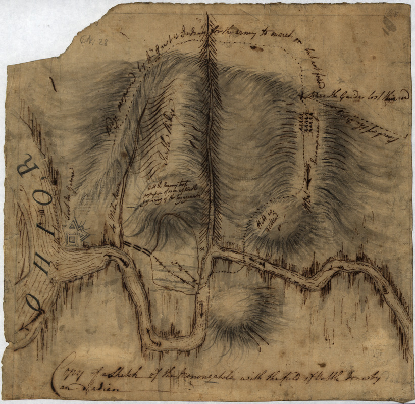
Copy of a sketch of the Monongahela, with the field of battle
This map is also available in American Revolutionary Geographies Online (ARGO), a collections portal especially built for material relating to the American Revolutionary War Era. Visit ARGO to learn more about this item and explore the historical geography of North America in the late eighteenth century.
Item Information
- Title:
- Copy of a sketch of the Monongahela, with the field of battle
- Creator:
- Montrésor, John, 1736-1799
- Name on Item:
-
done by an Indian
- Date:
-
[1755?]
- Format:
-
Maps/Atlases
Manuscripts
- Location:
- Library of Congress Geography and Map Division
- Collection (local):
-
Library of Congress Collection
- Subjects:
-
Monongahela, Battle of the, Pa., 1755--Maps, Manuscript
Pittsburgh (Pa.)--History--French and Indian War, 1754-1763--Maps, Manuscript
Monongahela River Valley (W. Va. and Pa.)--Maps, Manuscript--Early works to 1800
Fort Duquesne (Pa.)--Maps--Early works to 1800
- Places:
-
Monongahela River
Allegheny (county)Pittsburgh
- Extent:
- 1 manuscript map; on sheet 26 x 27 cm.
- Terms of Use:
-
No known copyright restrictions.
This work is licensed for use under a Creative Commons Attribution Non-Commercial Share Alike License (CC BY-NC-SA).

- Scale:
-
Scale not given
- Language:
-
English
- Catalog Record:
-
https://lccn.loc.gov/gm71002314
- Notes:
-
Manuscript, pen-and-ink and pencil.
Relief shown by hachures.
In this map the name Ohio R. ou la belle rivière is applied also to the Allegheny. The words "direction of" have been inserted in pencil between "By" and "an Indian."
"No. 28."
Includes notes.
On verso: John Montresor.
- Identifier:
-
ar302600

![[Ein grund-riss von der Festung Duquessne wie sie ausgesehen hat, ehe sie die Frankosen zerstoren aben, und zum theil noch aussiehet]](https://bpldcassets.blob.core.windows.net/derivatives/images/commonwealth:z603vv49q/image_thumbnail_300.jpg)


