Iraq country profile
Item Information
- Title:
- Iraq country profile
- Description:
-
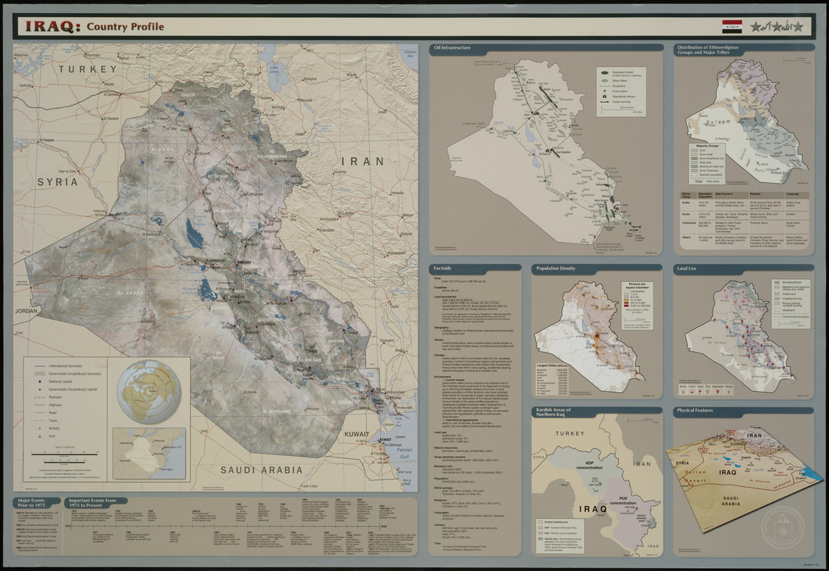
Besides a general reference map of the country based on Landsat imagery, this information-rich sheet also includes inset maps showing oil infrastructure, distribution of ethnoreligious groups and major tribes, population density, land use, Kurdish areas of northern Iraq, and physical features. There are also three tables listing major events prior to 1975, important events from 1975 to present, and "factoids.
- Creator:
- United States. Central Intelligence Agency. Cartography Center
- Date:
-
[2003]
- Format:
-
Maps/Atlases
- Location:
-
Boston Public Library
Central Library in Copley Square - Collection (local):
-
Government Documents
- Subjects:
-
Petroleum--Iraq--Maps
Ethnic groups--Iraq--Maps
Population density--Iraq--Maps
Land use--Iraq--Maps
Kurds--Iraq--Maps
Physical geography--Iraq--Maps
Iraq--Maps
Iraq--Religion--Maps
- Places:
-
Iraq
- Extent:
- 1 map : col. ; 54 x 50 cm., on sheet 69 x 100 cm.
- Terms of Use:
-
No known copyright restrictions.
No known restrictions on use.
- Publisher:
-
[Washington, D.C.] :
Central Intelligence Agency
- Scale:
-
Scale 1:2,000,000
- Projection:
- Lambert conformal conic proj., SP 29⁰30ʹN/36⁰40ʹN
- Language:
-
English
- Notes:
-
Relief shown by shading.
Shipping list no. not available.
"390460A1 7-03."
"764225A1 7-03."
"Background image composed of Landsat TM (bands 1, 2, 3), and DTED level 1."
Includes text, comparative area map, location map, and historical timeline.
Ancillary maps: Oil infrastructure -- Distribution of ethnoreligious groups and major tribes -- Population density -- Land use -- Kurdish areas of northern Iraq -- Physical features.
- Notes (date):
-
This date is inferred.
- Identifier:
-
06_01_000511
- Call #:
-
BPL Gov. Docs. Dept. PREX 3.10/4:IR 1/35
- Barcode:
-
mq5998267