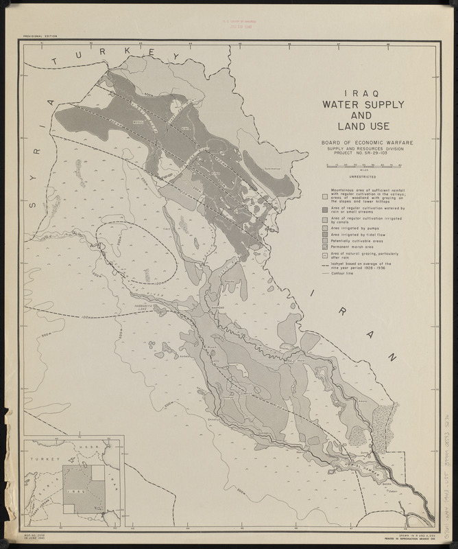
Iraq water supply and land use
Item Information
- Title:
- Iraq water supply and land use
- Cartographer:
- United States. Board of Economic Warfare. Supply and Resources Division
- Cartographer:
- United States. Office of Strategic Services. Research and Analysis Branch
- Name on Item:
-
Board of Economic Warfare, Supply and Resources Division ; drawn in R and A, OSS
- Date:
-
1943
- Format:
-
Maps/Atlases
- Location:
-
Boston Public Library
Norman B. Leventhal Map & Education Center - Collection (local):
-
Norman B. Leventhal Map & Education Center Collection
- Subjects:
-
Water-supply--Iraq--Maps
Land use--Iraq--Maps
Precipitation (Meteorology)--Iraq--Maps
Iraq--Maps
- Places:
-
Iraq
- Extent:
- 1 map ; 52 x 45 cm
- Terms of Use:
-
No known copyright restrictions.
No known restrictions on use.
- Publisher:
-
[Washington, D.C.] :
Printed in Reproduction Branch, OSS
- Edition:
- Provisional edition
- Scale:
-
Scale approximately 1:1,600,000
- Language:
-
English
- Notes:
-
Also shows isohyets.
Relief shown by contour lines.
"29 June 1943."
Includes location map.
"Map no. 2058."
"Project no. SR-29-103."
- Identifier:
-
06_01_015337
- Call #:
-
G7611.N44 1943 .U55
- Barcode:
-
39999085935276