Nouveau plan routier de la ville et faubourgs de Paris avec ses principaux édifices et nouvelles barrières
Item Information
- Title:
- Nouveau plan routier de la ville et faubourgs de Paris avec ses principaux édifices et nouvelles barrières
- Description:
-
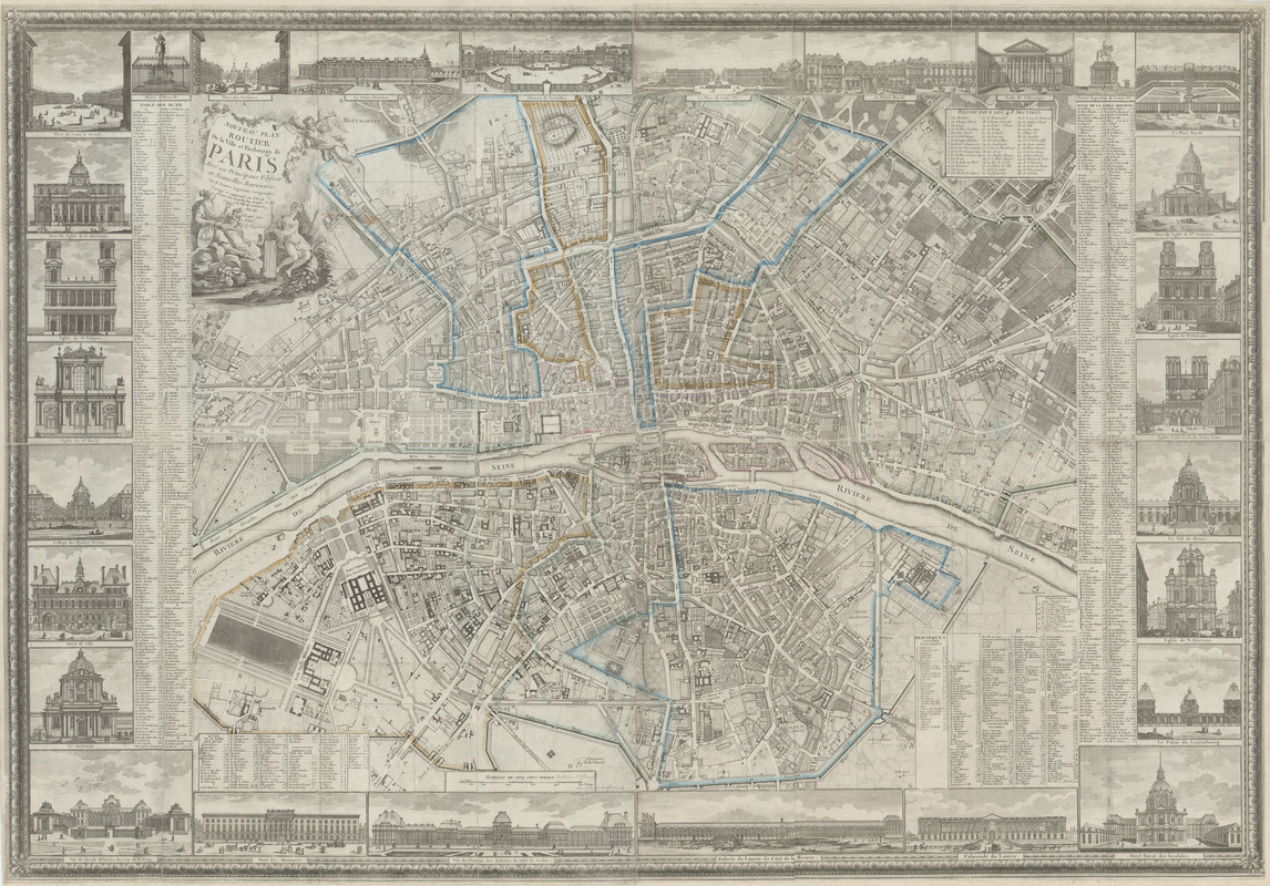
This map from 1802 shows Paris as it was reconstructed after the French Revolution in 1789—an altogether different view than that which was seen on maps from the end of the nineteenth century. For example, a third island in the Seine River, Isle Louvier, sits upstream of the recognizable Isle Saint-Louis. This small island was incorporated into the Right Bank in the mid-1800s. The new defensive wall, or Nouveau Mur, that surrounds the perimeter of the city on this map would later be demolished to make way for Paris’s expanding population. Evidence of this long-standing practice of knocking down old city walls and rebuilding new ones in a larger circle around the previous walls can be seen in the curved streets within the Nouveau Mur, as one moves closer to the islands in the Seine. This radial-concentric pattern of development is common to many fortified cities throughout Europe. Yet unlike other European cities, Paris had a long tradition of formal planning, made possible by centralized royal power, a large population, greater wealth, and more advanced technologies. It is also one of the few cities that expanded on both banks of its river from earliest times, which may account for its more equal distribution of development on both sides of the Seine.
- Cartographer:
- Pichon
- Engraver:
- Glot, C. B., active 18th century
- Engraver:
- Voysard, Etienne Claude, 1746-1812
- Publisher:
- Esnauts et Rapilly
- Name on Item:
-
par M. Pichon, ingenieur geographe ; gravé par Glot ; E. Voysard sc.
- Date:
-
[ca. 1801–1802]
- Format:
-
Maps/Atlases
- Location:
- MacLean Collection Map Library
- Collection (local):
-
MacLean Collection Map Library
- Subjects:
-
Paris (France)--Maps
Paris (France)--Buildings, structures, etc.--Pictorial works
- Places:
-
FranceParis
- Extent:
- 1 map : color ; 101 cm x 145 cm
- Terms of Use:
-
Public Domain/No known restrictions on use. Contact host institution to download image.
Contact host institution for more information.
- Publisher:
-
Paris :
Esnauts et Rapilly
- Scale:
-
Scale [ca. 1:7,100]
- Language:
-
French
- Notes:
-
Plan surrounded by 28 views of buildings and monuments.
Published 10 times between 1780 and 1805.
Copper plate engraving.
- Identifier:
-
MacLeanColl_3827_Paris
- Call #:
-
3827