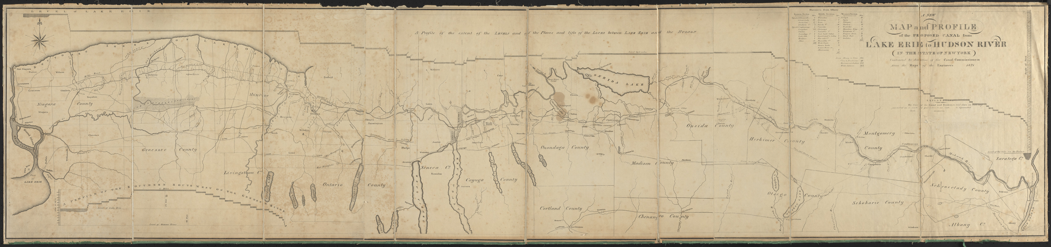
A new map and profile of the proposed canal from Lake Erie to Hudson River in the state of New York
Item Information
- Title:
- A new map and profile of the proposed canal from Lake Erie to Hudson River in the state of New York
- Description:
-
America Transformed: The Appalachian Mountains presented an obstacle for traffic flow from the Atlantic seaboard to the Midwest. After considering various projects to cross this barrier, the New York state government built the Erie Canal. Constructed from 1817 to 1825, the canal extended 363 miles connecting Albany (on the Hudson River) with Buffalo (on Lake Erie). Taking advantage of a natural break in the mountain chain, the route climbed an elevation of 568 feet, using 83 locks and 18 aqueducts, as depicted on this 1821 plan. Its successful completion and profitable operation ushered in an era of canal building in the United States.
- Creator:
- New York (State). Canal Commissioners
- Name on Item:
-
contracted by direction of the Canal Commissioners from the maps of the engineers
- Date:
-
1821
- Format:
-
Maps/Atlases
- Location:
- Private Collection
- Collection (local):
-
Private Collection
- Subjects:
-
Erie Canal (N.Y.)--Maps
- Places:
-
New YorkErie Canal
- Extent:
- 1 map ; 39 x 173 cm
- Terms of Use:
-
No known copyright restrictions.
No known restrictions on use.
- Publisher:
-
[New York] :
[Publisher not identified]
- Scale:
-
Scale 1:253,440
- Language:
-
English
- Notes:
-
Includes 2 profiles: A profile of the extent of the levels and of the places and lifts of the locks between Lake Erie and the Hudson -- A profile of th the southern route west of the Genesee River.
Includes chart of distances from Albany.
- Notes (exhibitions):
-
Exhibited: "America transformed. Part 1: the United States expands westward," organized by the Norman B. Leventhal Map & Education Center at the Boston Public Library, 2019.
- Identifier:
-
06_01_016725