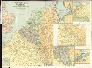
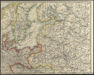
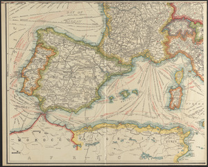
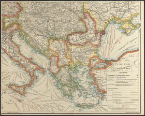
Strategic map of Central Europe showing the international frontiers


Item Information
- Title:
- Strategic map of Central Europe showing the international frontiers
- Creator:
- United States. War Department. General Staff. War College Division
- Cartographer:
- Williams, Arch. B.
- Cartographer:
- Bontz, Geo. F.
- Name on Item:
-
prepared in the War College Division, General Staff, War Department ; Arch. B. Williams and Geo. F. Bontz, draftsmen
- Date:
-
1915
- Format:
-
Maps/Atlases
- Location:
-
Boston Public Library
Norman B. Leventhal Map & Education Center - Collection (local):
-
Norman B. Leventhal Map & Education Center Collection
- Subjects:
-
World War, 1914-1918--Campaigns--Europe--Maps
Europe--Maps
- Places:
-
Europe
Europe
- Extent:
- 1 map on 4 sheets : color ; 146 x 178 cm, sheets 82 x 91 cm or smaller.
- Terms of Use:
-
No known copyright restrictions.
No known restrictions on use.
- Publisher:
-
Washington :
War College Division, General Staff, War Department
- Scale:
-
Scale 1:2,280,960
- Language:
-
English
- Notes:
-
Relief shown by hachures.
Shows Europe from Ireland and Portugal on the west, Moscow on the east, Trondheim, Norway on the north, and Crete on the south.
Shows steamship routes with estimated travel times, submarine cables, radio stations, naval bases, and fortified areas.
With special reference to the European War.
- Identifier:
-
06_01_012053A
06_01_012053B
06_01_012053C
06_01_012053D
- Call #:
-
G5700 1915 .U55
- Barcode:
-
39999065692798