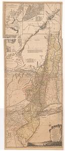
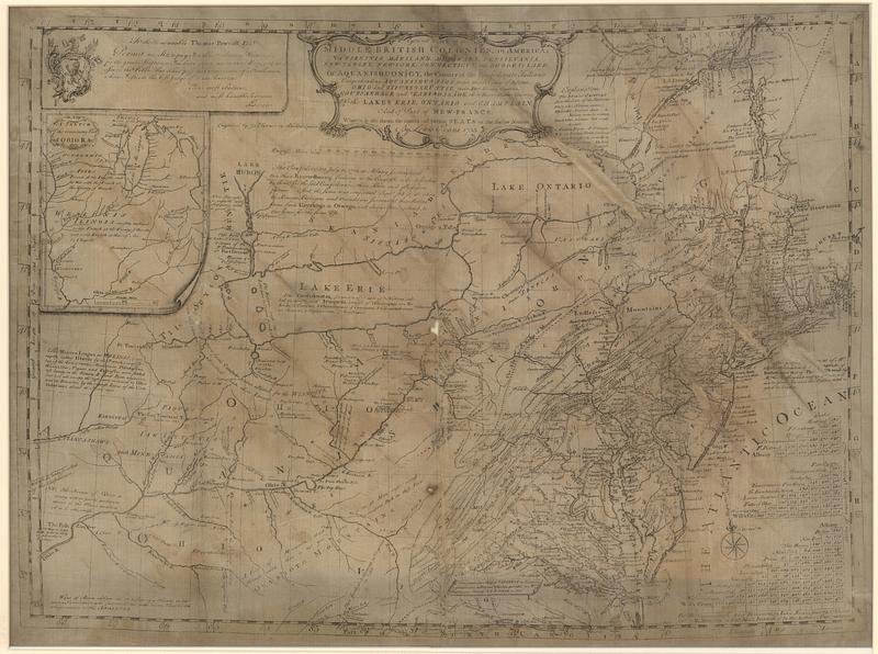
A general map of the Middle British Colonies, in America: viz Virginia, Mariland, Delaware, Pensilvania, New-Jersey, New-York, Connecticut, and Rhode-Island; of Aquanishuonigy, the country of the confederate Indians : comprehending Aquanishuonigy proper, their place of residence, Ohio and Tiuxsoxruntie their deer-hunting countries, Couxsaxrage and Skaniadarade, their beaver-hunting countries; of the lakes Erie, Ontario and Champlain, and of part of New-France: wherein is also shewn the antient and present seats of the Indian nations
This map is also available in American Revolutionary Geographies Online (ARGO), a collections portal especially built for material relating to the American Revolutionary War Era. Visit ARGO to learn more about this item and explore the historical geography of North America in the late eighteenth century.
Item Information
- Title:
- A general map of the Middle British Colonies, in America: viz Virginia, Mariland, Delaware, Pensilvania, New-Jersey, New-York, Connecticut, and Rhode-Island; of Aquanishuonigy, the country of the confederate Indians : comprehending Aquanishuonigy proper, their place of residence, Ohio and Tiuxsoxruntie their deer-hunting countries, Couxsaxrage and Skaniadarade, their beaver-hunting countries; of the lakes Erie, Ontario and Champlain, and of part of New-France: wherein is also shewn the antient and present seats of the Indian nations
- Publisher:
- Evans, Lewis, 1700?-1756
- Name on Item:
-
by Lewis Evans ; engraved by Ja.s Turner in Philadelphia
- Date:
-
June 23, 1755
- Format:
-
Maps/Atlases
- Location:
- MacLean Collection Map Library
- Collection (local):
-
MacLean Collection Map Library
- Subjects:
-
Middle Atlantic States--Maps--Early works to 1800
- Places:
-
Middle Atlantic (area)
- Extent:
- 1 map ; 484 x 668 mm
- Terms of Use:
-
Public Domain/No known restrictions on use. Contact host institution to download image.
Contact host institution for more information.
- Publisher:
-
Philadelphia + London :
Published according to act of Parliament, by Lewis Evans ; and sold by R. Dodsley in Pall-Mall, London & by the author in Philadelphia
- Edition:
- First state
- Language:
-
English
- Notes:
-
"To the honourable Thomas Pownall esq.r permit me, sir, to pay you this tribute of gratitude, for the great assistance you have given me in this map and to assure the public, that it has past the examination of a gentleman, whom I esteem the best judge of it in America: your most obedient, and most humble servant, levans."
- Identifier:
-
MC_19894
- Call #:
-
19894