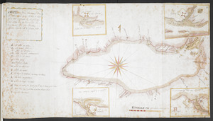
Lake Ontario & River S.t Laurence from the Lake to Fort William Augustus in Three Rivers, this was taken from a French Draft that was on Board the Prise Williamson belonging to Monsr La Broquerie [west sheet]
![Lake Ontario & River S.t Laurence from the Lake to Fort William Augustus in Three Rivers, this was taken from a French Draft that was on Board the Prise Williamson belonging to Monsr La Broquerie [west sheet]](https://bpldcassets.blob.core.windows.net/derivatives/images/commonwealth:hx11z139v/image_access_800.jpg)
This map is also available in American Revolutionary Geographies Online (ARGO), a collections portal especially built for material relating to the American Revolutionary War Era. Visit ARGO to learn more about this item and explore the historical geography of North America in the late eighteenth century.
Item Information
- Title:
- Lake Ontario & River S.t Laurence from the Lake to Fort William Augustus in Three Rivers, this was taken from a French Draft that was on Board the Prise Williamson belonging to Monsr La Broquerie [west sheet]
- Description:
-
Shows Lake Ontario and the River Saint Lawrence as far as lower Montreal (although the title page suggests detail extends eastwards as far as Three Rivers).
- Cartographer:
- Brasier, William
- Associated name:
- La Broquerie, Pierre Boucher de
- Associated name:
- Labrosse, Paul, 1697-1769
- Associated name:
- Ratzer, Bernard
- Former owner:
- Amherst, Jeffery Amherst, Baron, 1717-1797
- Former owner:
- Royal United Services Institute for Defence and Security Studies
- Date:
-
[ca. 1760]
- Format:
-
Maps/Atlases
- Location:
- British Library
- Collection (local):
-
British Library Collection
- Subjects:
-
Fortification--Ontario, Lake (N.Y. and Ont.)--Maps, Manuscript--Early works to 1800
Ontario, Lake (N.Y. and Ont.)--Maps, Manuscript--Early works to 1800
Saint Lawrence River--Maps, Manuscript--Early works to 1800
- Places:
-
Ontario, Lake
Saint Lawrence River
- Extent:
- 1 map on 7 sheets : joined and presented in 3 parts, manuscript pen and ink with watercolour, accompanied by an additional title sheet ; sheet 46 x 125 cm
- Terms of Use:
-
No known copyright restrictions.
This work is licensed for use under a Creative Commons Attribution Non-Commercial Share Alike License (CC BY-NC-SA).

- Publisher:
-
[Place of production not identified] :
[William Brasier]
- Scale:
-
Scale varies
- Language:
-
English
- Catalog Record:
-
http://searcharchives.bl.uk/IAMS_VU2:IAMS040-001999739
- Notes:
-
Date suggested from information given on map, "Battery on Amhert's Island in 1760" (previous British Library catlaoguing suggests a date of about 1750).
Cartographer attributed on stylisitic grounds (previous British Library cataloguing suggested Paul Labrosse as cartographer but this map bears no similaries with his hand. However, Labrosse's survey/map may have been the original "sketch" referred to in this map's title as having been taken from La Broquerie's vessel).
Shows Fort Toronto, Fort Niagara, Fort Frontenac and Fort Ontario on Lake Niagara.
Shows scale bar on most easterly sheet, "A Scale of 5 French Leagues" with the note "This Scale serves only for those two Sheets, the originals of the two other parts of the Draught not having any Scale affixed to them" (scale approximately 1:151,000).
Previous British Library cataloguing refers to signature of William Brasier - "W B" (?) shown in pencil on Add Ms 57,709.2.
See Add Ms 57,710.1. for the part of the map showing Fort William Augustus, including a note that the fort was surveyed by Bernard Ratzer.
Copy at Add Ms 57,709.3. (4 sheets joined to form piece 71 x 172 cm) shows Lake Ontario. Green label to verso shows "14A". White label to verso shos "DRAWER 27 SECTION 3". Blue label to verso shows "A 27/31B". Copy at Add Ms 57,709.2. (1 sheet, 56 x 53 cm) shows the Saint Lawrence river from Lake Ontario to present-day Galop Island. blank green label to verso. White label to verso shows "DRAWER 27 SECTION 2". Blue label to verso shows "A28/57". Copy at Add Ms 57,709.1.(2 sheets joined to form piece 46 x 125 cm) shows the River Saint Lawrence extending from beyond Galop Island to the lower part of Montreal Island. Red stamp of the R.U.S.I. to this sheet. Green label to verso shows "2". White label to verso shows "DRAWER 27 SECTION 3". Blue label to verso shows "A 27/31A". The title is given on a separate sheet (32 x 20 cm). All sheets laid on linen and stamped with pressmark to verso.
- Notes (date):
-
9999

![Lake Ontario & River S.t Laurence from the Lake to Fort William Augustus in Three Rivers, this was taken from a French Draft that was on Board the Prise Williamson belonging to Monsr La Broquerie [east sheet]](https://bpldcassets.blob.core.windows.net/derivatives/images/commonwealth:hx11z135r/image_thumbnail_300.jpg)
![Lake Ontario & River S.t Laurence from the Lake to Fort William Augustus in Three Rivers, this was taken from a French Draft that was on Board the Prise Williamson belonging to Monsr La Broquerie [middle sheet]](https://bpldcassets.blob.core.windows.net/derivatives/images/commonwealth:hx11z1379/image_thumbnail_300.jpg)
![[Lake Ontario]](https://bpldcassets.blob.core.windows.net/derivatives/images/commonwealth:hx11xz576/image_thumbnail_300.jpg)
