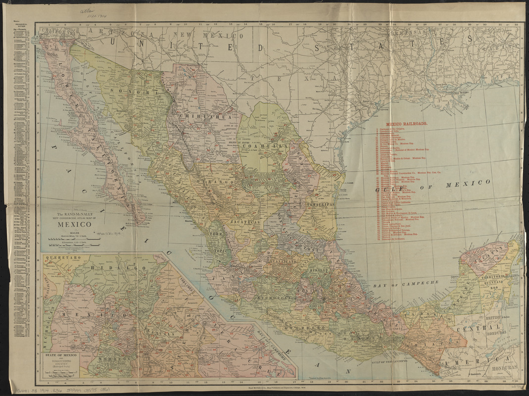
The Rand-McNally new commercial atlas map of Mexico
Item Information
- Title:
- The Rand-McNally new commercial atlas map of Mexico
- Title (alt.):
-
New commercial atlas of Mexico
Rand McNally & Co.'s indexed pocket map and shippers' guide of Mexico : accompanied by a new and original compilation and ready reference index, showing in detail the entire railroad system, the express company doing business over each road, and accurately locating all states and territories, cities, towns, post offices, railroad stations, villages, islands, lakes, rivers, etc.
Indexed pocket map and shippers' guide of Mexico
Rand McNally & Co.'s Mexico
Rand-McNally indexed county and railroad pocket map and shippers' guide of Mexico : showing railroads, cities, towns, villages, post offices, lakes, river, etc.
- Publisher:
- Rand McNally and Company
- Date:
-
1914
- Format:
-
Maps/Atlases
- Location:
-
Boston Public Library
Norman B. Leventhal Map & Education Center - Collection (local):
-
Norman B. Leventhal Map & Education Center Collection
- Subjects:
-
Railroads--Mexico--Maps
Mexico--Maps
- Places:
-
Mexico
- Extent:
- 1 map : color ; 48 x 67 cm, folded to 17 x 11 cm + index (74 pages ; 17 cm)
- Terms of Use:
-
No known copyright restrictions.
No known restrictions on use.
- Publisher:
-
Chicago :
Rand McNally & Co.
- Scale:
-
Scale 1:4,561,920
- Language:
-
English
- Notes:
-
Relief shown by hachures.
Numbered list of railroads in red overprint at top of map; numbers in red indicate these railroads throughout the country.
Includes index of principal cities and population figures in left margin.
Inset: State of Mexico and surrounding country (enlarged scale).
Accompanied by index.
- Identifier:
-
06_01_016665
- Call #:
-
G4411.P3 1914 .R36
- Barcode:
-
39999085950861