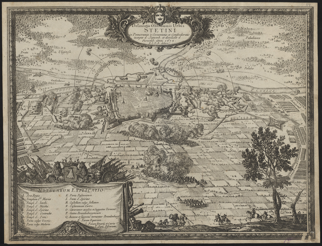
Delineatio obsidionis urbis Stetini in Pomerania à Cesareanis et Confoederatis incaeptae d. Septemb. et derelictae d. Novemb. Anni 1659
Item Information
- Title:
- Delineatio obsidionis urbis Stetini in Pomerania à Cesareanis et Confoederatis incaeptae d. Septemb. et derelictae d. Novemb. Anni 1659
- Cartographer:
- Dahlbergh, Erik Jönsson, greve, 1625-1703
- Publisher:
- Riegel, Christoph
- Contributor:
- Pufendorf, Samuel, Freiherr von, 1632-1694
- Name on Item:
-
E.I.D.B. delinea.
- Date:
-
[1696]
- Format:
-
Maps/Atlases
- Location:
-
Boston Public Library
Norman B. Leventhal Map & Education Center - Collection (local):
-
Norman B. Leventhal Map & Education Center Collection
- Subjects:
-
Swedish-Polish War, 1655-1660--Campaigns--Maps--Early works to 1800
Szczecin (Poland)--Maps--Early works to 1800
- Places:
-
PolandSzczecin
- Extent:
- 1 view ; 27 x 36 cm
- Terms of Use:
-
No known copyright restrictions.
No known restrictions on use.
- Publisher:
-
[Nuremberg] :
[Sumptibus Christophori Riegelij]
- Scale:
-
Not drawn to scale
- Language:
-
Latin
- Notes:
-
Bird's-eye view map showing the siege of Stettin in 1659, including fortifications and artillery.
From Samuel von Pufendorf's De rebus a Carolo Gustavo Sueciae rege gestis commentariorum libri septem. Norimbergae : Sumptibus Christophori Riegelij, 1696.
Includes title cartouche and illustrations of battle in the foreground.
"N. 106" --Lower right margin.
Conservation of this piece was funded by Anna Kuznetsova-Schafer and Ronald Schafer.
- Notes (date):
-
This date is inferred.
- Identifier:
-
06_01_016442
- Call #:
-
G2070 .P84 1696
- Barcode:
-
30000006603502