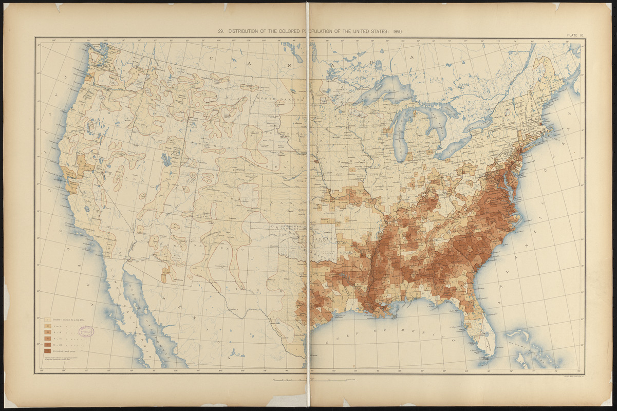
Distribution of the colored population of the United States : 1890
Item Information
- Title:
- Distribution of the colored population of the United States : 1890
- Description:
-
America Transformed: The African American population grew from 4.4 million at the beginning of the Civil War to 7.5 million in 1890, representing 12 percent of the country's total population. This map from the statistical atlas using 1890 census data employs six shades of brown to indicate population distribution and density. Most African Americans remained in the Southeast, but many moved to Midwestern and Northeastern states. They established communities in urban areas like St. Louis, Indianapolis, Cincinnati, Philadelphia, New York and Boston.
- Creator:
- United States. Census Office
- Cartographer:
- Gannett, Henry, 1846-1914
- Lithographer:
- Julius Bien & Co.
- Date:
-
[1898]
- Format:
-
Maps/Atlases
- Location:
-
Boston Public Library
Norman B. Leventhal Map & Education Center - Collection (local):
-
Norman B. Leventhal Map & Education Center Collection
- Subjects:
-
United States--Population--Maps
United States--Census, 1890
African Americans--Population--Maps
- Places:
-
United States
- Extent:
- 1 map : color ; 43 x 71 cm, on sheet 53 x 80 cm
- Terms of Use:
-
No known copyright restrictions.
No known restrictions on use.
- Publisher:
-
[Washington] :
[Government Printing Office]
- Scale:
-
Scale approximately 1:7,000,000
- Language:
-
English
- Notes:
-
From Statistical atlas of the United States: based upon the results of the eleventh census / by Henry Gannett. Washington : Government Printing Office, 1898.
"Plate 10."
- Notes (date):
-
This date is inferred.
- Notes (exhibitions):
-
Exhibited: "America transformed. Part 2: homesteads to modern cities," organized by the Norman B. Leventhal Map & Education Center at the Boston Public Library, 2019-2020.
- Identifier:
-
06_01_016798
- Call #:
-
G1200 .U55 1898
- Barcode:
-
39999065670984