Distribution of the population of the United States : 1890
Item Information
- Title:
- Distribution of the population of the United States : 1890
- Description:
-
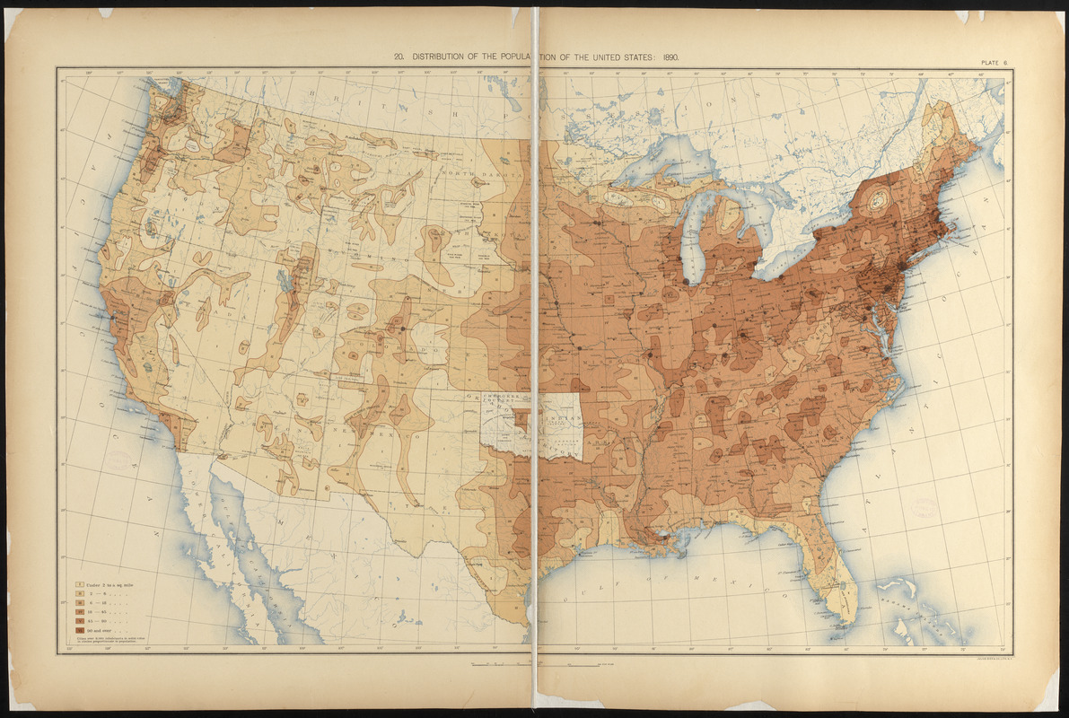
America Transformed: Prepared by the Census Office using 1890 data, this map illustrates the distribution of population across the country. Darker colors represent denser populations. Based on maps like this, historian Frederick Jackson Turner declared that America no longer had a frontier, which he defined as "the meeting point between savagery and civilization." He believed that the violent conquest of the West shaped "American character," marked by rugged individualism, inventiveness, and intuitive mastery over the physical landscape. Many agreed with his "frontier thesis" and feared for rising generations who would no longer have the challenge of fighting native people and dominating a wild landscape.
America Transformed: Viewpoint: On the other hand, Native people saw the frontier thesis as a genocidal tactic of forcibly transferring a culture from one state of being to another. Native peoples viewed the frontier as a coming of great change and impending doom. Rather than expansion, the frontier closed in on and choked out Native territories. Cultures that for thousands of years managed and sustained themselves in this "wild landscape" were now forced into American "civilization" and "improvement" as the new American population spread. –Chris Newell (Passamaquoddy), endawnis Spears (Navajo, Ojibwe, Chickasaw, Choctaw), Dr. Jason Mancini Ph.D., Akomawt Educational Initiative
- Creator:
- United States. Census Office
- Cartographer:
- Gannett, Henry, 1846-1914
- Lithographer:
- Julius Bien & Co.
- Date:
-
[1898]
- Format:
-
Maps/Atlases
- Location:
-
Boston Public Library
Norman B. Leventhal Map & Education Center - Collection (local):
-
Norman B. Leventhal Map & Education Center Collection
- Subjects:
-
United States--Population--Maps
United States--Census, 1890
- Places:
-
United States
- Extent:
- 1 map : color ; 43 x 71 cm, on sheet 53 x 80 cm
- Terms of Use:
-
No known copyright restrictions.
No known restrictions on use.
- Publisher:
-
[Washington] :
[Government Printing Office]
- Scale:
-
Scale approximately 1:7,000,000
- Language:
-
English
- Notes:
-
From Statistical atlas of the United States: based upon the results of the eleventh census / by Henry Gannett. Washington : Government Printing Office, 1898.
"Plate 6."
- Notes (date):
-
This date is inferred.
- Notes (exhibitions):
-
Exhibited: "America transformed. Part 2: homesteads to modern cities," organized by the Norman B. Leventhal Map & Education Center at the Boston Public Library, 2019-2020.
- Identifier:
-
06_01_016796
- Call #:
-
G1200 .U55 1898
- Barcode:
-
39999065670984