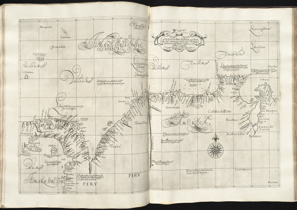
Carta particolare del'India Occidentale che comincia con il Capo S. Romano nel' mare del' nort è finisce con il' Rio Coquele
Item Information
- Title:
- Carta particolare del'India Occidentale che comincia con il Capo S. Romano nel' mare del' nort è finisce con il' Rio Coquele
- Creator:
- Dudley, Robert, Sir, 1574-1649
- Engraver:
- Lucini, Antonio Francesco, b. 1605
- Name on Item:
-
A. F. Lucini fece.
- Date:
-
[1647]
- Format:
-
Maps/Atlases
- Location:
-
Boston Public Library
Norman B. Leventhal Map & Education Center - Collection (local):
-
Norman B. Leventhal Map & Education Center Collection
- Subjects:
-
Coasts--Colombia--Maps--Early works to 1800
Coasts--Panama--Maps--Early works to 1800
Coasts--Venezuela--Maps--Early works to 1800
Nautical charts--Early works to 1800
Colombia--Maps--Early works to 1800
Panama--Maps--Early works to 1800
Venezuela--Maps--Early works to 1800
- Places:
-
Venezuela
Panama
Colombia
- Extent:
- 1 map ; 48 x 75 cm.
- Terms of Use:
-
No known copyright restrictions.
No known restrictions on use.
- Publisher:
-
Firenze :
Francesco Onofri
- Scale:
-
Scale [ca. 1:2,200,000]
- Language:
-
Italian
- Notes:
-
Covers parts of Panama, Colombia, and Venezuela, showing coastal towns, harbors, prevailing winds, ocean currents, and magnetic deviations of the compass.
Depth shown by soundings.
Prime meridian: Pico.
"D'America carta VIIII."
In Dudley's Dell'arcano del mare, 1646-1647.
Cataloging, conservation, and digitization made possible in part by The National Endowment for the Humanities: Exploring the human endeavor.
- Notes (date):
-
This date is inferred.
- Identifier:
-
06_01_010156
- Call #:
-
G1059 .D84 1647
- Barcode:
-
30000003234604