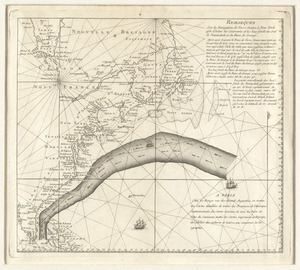
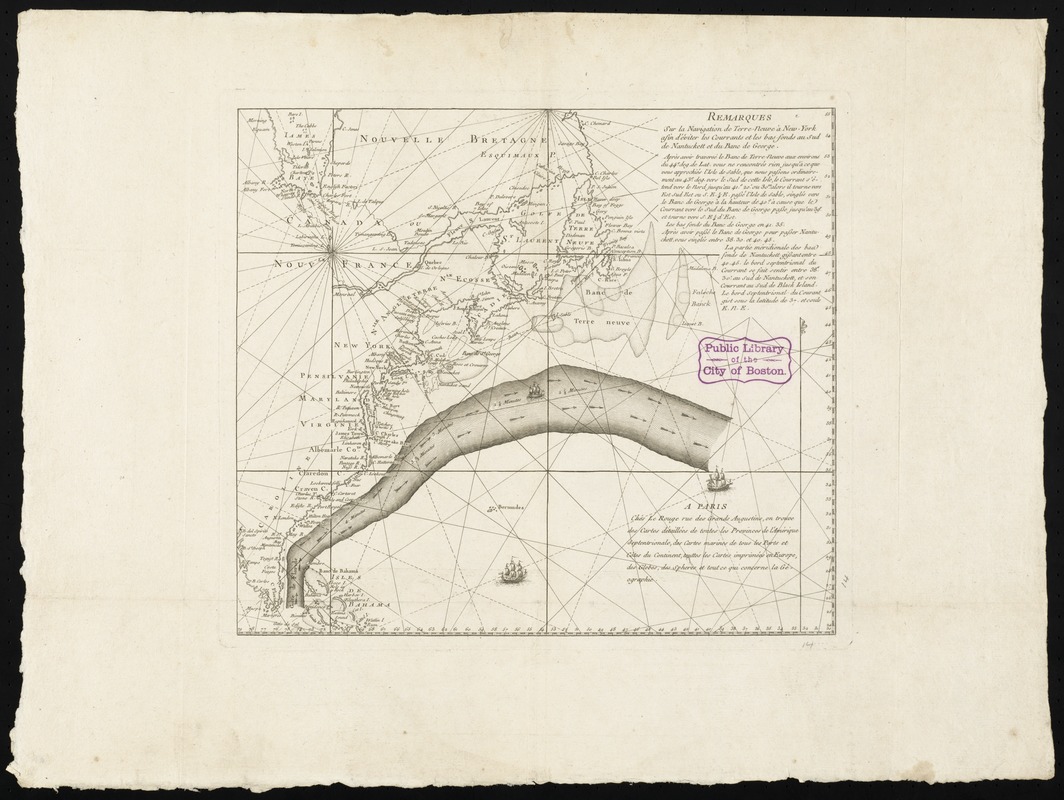
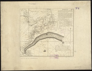
Remarques sur la navigation de terre-neuve à New-York afin d'eviter les courrants et les bas-fonds au sud de Nantuckett et du Banc de George
This map is also available in American Revolutionary Geographies Online (ARGO), a collections portal especially built for material relating to the American Revolutionary War Era. Visit ARGO to learn more about this item and explore the historical geography of North America in the late eighteenth century.
Item Information
- Title:
- Remarques sur la navigation de terre-neuve à New-York afin d'eviter les courrants et les bas-fonds au sud de Nantuckett et du Banc de George
- Title (alt.):
-
Collection of North American maps
- Description:
-
We Are One: One of the preferred routes that captains and navigators sailing from America to England learned to use was the Gulf Stream, a strong, warm current that flows north along the Atlantic coast and then east toward Europe. Initially charted by Benjamin Franklin in 1768, this discovery helped ships minimize travel time across the ocean, speeding up the transatlantic voyage for travelers, merchants, and goods. Franklin purchased this 1785 chart, a French adaptation of his original findings, when he served in Paris as a diplomat for the United States during the early years of the republic.
- Creator:
- Le Rouge, Georges-Louis.
- Date:
-
[1785]
- Format:
-
Maps/Atlases
- Location:
-
Boston Public Library
Norman B. Leventhal Map & Education Center - Collection (local):
-
Norman B. Leventhal Map & Education Center Collection
- Subjects:
-
Gulf Stream--Maps
- Places:
-
Atlantic Ocean
- Extent:
- 1 map ; 32 x 36 cm. on sheet 47 x 62 cm.
- Terms of Use:
-
No known copyright restrictions.
No known restrictions on use.
- Publisher:
-
A Paris :
Chéz Le Rouge, rue des Grands Augustins ...
- Scale:
-
Scale not given
- Language:
-
French
- Notes:
-
Based on Timothy Folger's original annotations ... It would appear that [Benjamin] Franklin added little or nothing beyond the red lines which indicated the portion to be reproduced ...--De Vorsey, L. Pioneer charting of the Gulf Stream, in Imago mundi, 28 (1976), p. 107.
Conservation of this piece was funded by Lavinia Lee Witt Touchton of Tampa, Florida in memory of her father, Currie B. Witt, whose study of Benjamin Franklin "was a positive influence in his life."
This map can be viewed as a georeferenced overlay in an interactive application made especially for We Are One: Mapping America's Road from Revolution to Independence http://d2o8owo4k087al.cloudfront.net/index.html?mapId=24.
Boston Public Library copy in portfolio with a map of the middle British colonies in North America once belonging to Benjamin Franklin. Note reads: "These maps belonged to a lot brought by Dr. Franklin from Europe, and are given to this Library by Dr. Thomas Hewson Bache, 233 South 13th St., Phil. Recd. this Dr. S.A. Green.
- Notes (date):
-
This date is inferred.
- Notes (exhibitions):
-
Exhibited: "Regions and Seasons: Mapping Climate through History" organized by the Norman B. Leventhal Map Center at the Boston Public Library, 2017.
Exhibited: "We Are One: Mapping America's Road from Revolution to Independence" organized by the Norman B. Leventhal Map Center at the Boston Public Library, 2015.
- Identifier:
-
06_01_008788
- Call #:
-
G3300 1776 .F73x
- Barcode:
-
30000003833697

![[Chart of the Gulf Stream]](https://bpldcassets.blob.core.windows.net/derivatives/images/commonwealth:z603vr47j/image_thumbnail_300.jpg)