The public schools of Massachusetts
Item Information
- Title:
- The public schools of Massachusetts
- Description:
-
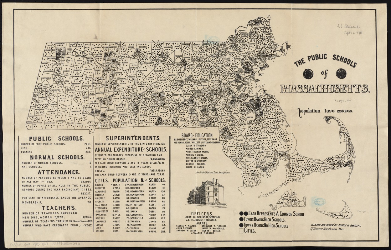
Massachusetts has historically been a leader in providing free education for children since the late 18th century. After the American Revolutionary War, public education at the elementary level was open to both male and female children, and geography was consistently part of the curriculum. George Bartlett, an artist and school principal, produced this map illustrating the number of public schools by town throughout the state in 1892. At this time, there were over 7,000 public schools throughout the commonwealth, with women accounting for over 90% of teachers.
- Creator:
- Bartlett, George Hartnell, 1838-1923
- Name on Item:
-
designed and drawn by George H. Bartlett.
- Date:
-
[1893]
- Format:
-
Maps/Atlases
- Location:
-
Boston Public Library
Norman B. Leventhal Map & Education Center - Collection (local):
-
Norman B. Leventhal Map & Education Center Collection
- Subjects:
-
Public schools--Massachusetts--Maps
Public schools--Massachusetts--Statistics
Education--Massachusetts--Maps
Education--Massachusetts--Statistics
Massachusetts--Maps
- Places:
-
Massachusetts
- Extent:
- 1 map ; 44 x 69 cm.
- Terms of Use:
-
No known copyright restrictions.
No known restrictions on use.
- Publisher:
-
Boston :
[s.n.]
- Scale:
-
Scale [ca. 1:480,000]
- Language:
-
English
- Notes:
-
Includes statistical tables, list of members and officers of the Board of Education, and ill. of Boys English High and Latin School, Boston.
- Notes (date):
-
This date is inferred.
- Notes (exhibitions):
-
Exhibited: "Back to School: Geography in the Classroom" organized by the Norman B. Leventhal Map Center at the Boston Public Library, 2014-2015.
- Identifier:
-
06_01_009952
- Call #:
-
G3761.E68 1893 .B37
- Barcode:
-
39999065666461


