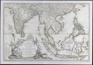
Tabula Indiae orientalis
Item Information
- Title:
- Tabula Indiae orientalis
- Title (alt.):
-
Collection of old maps
- Creator:
- Wit, Frederik de.
- Name on Item:
-
emendata a F. de Wit.
- Date:
-
1662
- Format:
-
Maps/Atlases
- Location:
-
Boston Public Library
Norman B. Leventhal Map & Education Center - Collection (local):
-
Norman B. Leventhal Map & Education Center Collection
- Subjects:
-
Southeast Asia--Maps--Early works to 1800
South Asia--Maps--Early works to 1800
- Places:
-
Southeast Asia (area)
Southern Asia (area)
- Extent:
- 1 map ; 45 x 56 cm.
- Terms of Use:
-
No known copyright restrictions.
No known restrictions on use.
- Publisher:
-
Amsterdam :
[Janssonius]
- Scale:
-
Scale [ca. 1:13,750,000]
- Language:
-
Latin
- Notes:
-
Relief shown pictorially.
From Jansson's Tooneel der vermaarste koop-steden en handel-plaaten van de geheele wereld, 1682.
"Joannes Lhuilier fecit."
Cataloging, conservation, and digitization made possible in part by The National Endowment for the Humanities: Exploring the human endeavor.
Part of composite portfolio atlas with title "Collection of old maps."
- Identifier:
-
06_01_009243
- Call #:
-
G1015 .C65 1630
- Barcode:
-
30000003854371