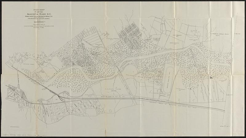
Index map of land near Anacostia River D.C. between district line and Baltimore & Potomac R.R. : from records of the District of Columbia
Item Information
- Title:
- Index map of land near Anacostia River D.C. between district line and Baltimore & Potomac R.R. : from records of the District of Columbia
- Cartographer:
- United States. Army. Corps of Engineers
- Date:
-
[1899]
- Format:
-
Maps/Atlases
- Location:
-
Boston Public Library
Norman B. Leventhal Map & Education Center - Collection (local):
-
Norman B. Leventhal Map & Education Center Collection
- Subjects:
-
Anacostia River (Md. and Washington, D.C.)--Maps
Real property--Washington (D.C.)--Maps
- Places:
-
Anacostia River
- Extent:
- 1 map ; 50 x 89 cm
- Terms of Use:
-
No known copyright restrictions.
No known restrictions on use.
- Publisher:
-
[Washington] :
[Government Printing Office]
- Scale:
-
Scale approximately 1:7,200
- Language:
-
English
- Notes:
-
Oriented with north to the upper right.
"To accompany report of Lieut. Col. Chas. J. Allen, Corps of Engineers, U.S.A. December 1st 1898."
In lower right: H Doc 87 55 3.
From Congressional serial set, 55th Congress, 3d session, House reports (Washington : Government Printing Office, 1899).
- Notes (date):
-
This date is inferred.
- Identifier:
-
06_01_018364
- Call #:
-
G3852.A5G46 1898 .I53
- Barcode:
-
39999085966800