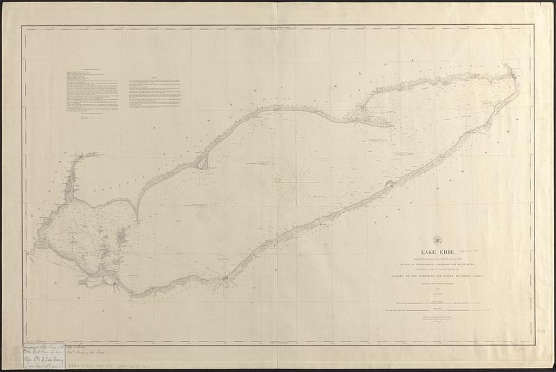
Lake Erie
Item Information
- Title:
- Lake Erie
- Issuing body:
- U.S. Lake Survey
- Contributor:
- Lee, Thomas Jefferson, 1808-1891
- Draftsman:
- Lambert, John
- Contributor:
- United States. Topographical Bureau
- Name on Item:
-
compiled from surveys made under the direction of the Bureau of Topographical Engineers, War Department, in obedience to acts of Congress requiring the survey of the northern and north western lakes, and from other reliable information, 1849 ; reduction for engraving by John Lambert, draughtsman, under the direction of T.J. Lee
- Date:
-
1853
- Format:
-
Maps/Atlases
- Genre:
-
Nautical charts
- Location:
-
Boston Public Library
Norman B. Leventhal Map & Education Center - Collection (local):
-
Norman B. Leventhal Map & Education Center Collection
- Subjects:
-
Erie, Lake--Maps
Nautical charts--Erie, Lake
- Places:
-
Erie, Lake
- Extent:
- 1 map ; 60 x 97 cm
- Terms of Use:
-
No known copyright restrictions.
No known restrictions on use.
- Publisher:
-
Washington, D.C. :
[Survey of the Lakes]
- Scale:
-
Scale 1:400,000
- Language:
-
English
- Notes:
-
Depths shown by soundings and isolines.
Prime meridians: Washington and Greenwich.
Includes sailing directions and notes.
Label pasted in lower left corner: Presented to the Public Library of the City of Boston by Capt. Geo. G. Meade Top. Engrs. Supdt. Survey of the Lakes.
- Notes (citation):
-
Karpinski, 792
- Identifier:
-
06_01_017412
- Call #:
-
G3312.E7P53 1853 .U83
- Barcode:
-
39999085959177