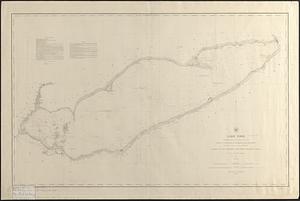
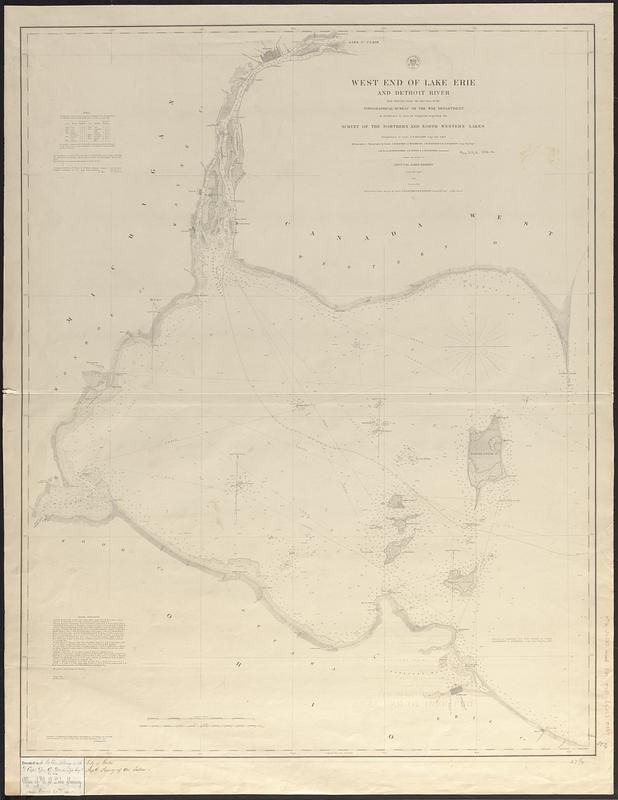
West end of Lake Erie and Detroit River : from surveys under the direction of the Topographical Bureau of the War Department, in obedience to acts of Congress requiring the survey of the northern and north western lakes
Item Information
- Title:
- West end of Lake Erie and Detroit River : from surveys under the direction of the Topographical Bureau of the War Department, in obedience to acts of Congress requiring the survey of the northern and north western lakes
- Issuing body:
- U.S. Lake Survey
- Surveyor:
- Macomb, J. N. (John N.), 1810 or 1811-1889
- Surveyor:
- Woodruff, I. C.
- Surveyor:
- Gunnison, J. W. (John Williams), 1812-1853
- Surveyor:
- Scammon, E. P. (Eliakin P.)
- Surveyor:
- Burgess, R. W.
- Surveyor:
- Peter, J. F.
- Surveyor:
- Forster, John Harris, 1822-1894
- Surveyor:
- Kearney, James, -1862
- Draftsman:
- Lambert, John
- Engraver:
- Smith, W.
- Contributor:
- United States. Topographical Bureau
- Name on Item:
-
triangulation by Lieut. J.N. Macomb Corps Topl. Engrs. ; hydrography & topography by Lieuts. J.N. Macomb, I.C. Woodruff, J.W. Gunnison & E.P. Scammon Corps Topl. Engrs. and Messrs. R.W. Burgess, J.F. Peter & J.H. Forster assistants ; under the orders of Lieut. Col. James Kearney Corps Topl. Engrs. 1849 ; reduction for engraving by John Lambert draughtsman and engraved by W. Smith under the direction of Capt. T.J. Lee Corps Topl. Engrs.
- Date:
-
1852
- Format:
-
Maps/Atlases
- Genre:
-
Nautical charts
- Location:
-
Boston Public Library
Norman B. Leventhal Map & Education Center - Collection (local):
-
Norman B. Leventhal Map & Education Center Collection
- Subjects:
-
Erie, Lake--Maps
Detroit River (Mich. and Ont.)--Maps
Nautical charts--Erie, Lake
Nautical charts--Detroit River (Mich. and Ont.)
- Places:
-
Erie, Lake
Detroit River
- Extent:
- 1 map ; 90 x 71 cm
- Terms of Use:
-
No known copyright restrictions.
No known restrictions on use.
- Publisher:
-
Washington, D.C. :
[Survey of the Lakes]
- Scale:
-
Scale 1:120,000
- Language:
-
English
- Notes:
-
Depths shown by soundings and isolines.
Includes sailing directions and water level table.
"Detroit River from surveys by Lieuts. J.N. Macomb & W.H. Warner Corps Topl. Engrs. in 1840 '41 & '42."
Label pasted in lower left corner: Presented to the Public Library of the City of Boston by Capt. Geo. G. Meade Top. Engrs. Supdt. Survey of the Lakes.
- Notes (citation):
-
Karpinski, 1790
Moore, 1-0211
- Identifier:
-
06_01_017411
- Call #:
-
G3312.E7P53 1852 .U83
- Barcode:
-
39999085959169