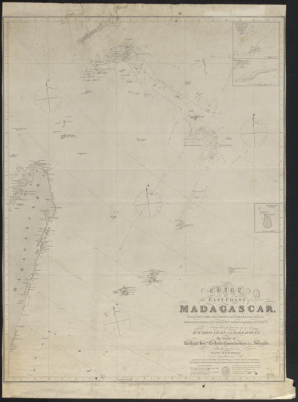
Chart of the east coast of Madagascar, including the Mauritius, Seychelle islands &c. between the latitudes of 2°30' & 26°30' S. and the longitudes of 47° & 67° E. : from the operations of H.M. ships Leven and Barracouta, by order of the Right Honble. the Lords Commissioners of the Admiralty ; under the direction of Captn. W.F.W. Owen, from 1822 to 1826 ; assisted by Capt. A.T.E. Vidal [and 12 others] ; J. & C. Walker sculpt.
Item Information
- Title:
- Chart of the east coast of Madagascar, including the Mauritius, Seychelle islands &c. between the latitudes of 2°30' & 26°30' S. and the longitudes of 47° & 67° E. : from the operations of H.M. ships Leven and Barracouta, by order of the Right Honble. the Lords Commissioners of the Admiralty ; under the direction of Captn. W.F.W. Owen, from 1822 to 1826 ; assisted by Capt. A.T.E. Vidal [and 12 others] ; J. & C. Walker sculpt.
- Issuing body:
- Great Britain. Hydrographic Office
- Surveyor:
- Owen, W. F. W., 1774-1857
- Surveyor:
- Vidal, A. T. E. (Alexander Thomas Emeric), 1792-1863
- Engraver:
- J. & C. Walker (Firm)
- Date:
-
[1867]
- Format:
-
Maps/Atlases
- Genre:
-
Nautical charts
- Location:
-
Boston Public Library
Norman B. Leventhal Map & Education Center - Collection (local):
-
Norman B. Leventhal Map & Education Center Collection
- Subjects:
-
Madagascar--Maps
Mauritius--Maps
Seychelles--Maps
Coasts--Madagascar--Maps
Nautical charts--Madagascar
Nautical charts--Mauritius
Nautical charts--Seychelles
- Places:
-
Madagascar
Mauritius
Seychelles
- Extent:
- 1 map ; 77 x 59 cm
- Terms of Use:
-
No known copyright restrictions.
No known restrictions on use.
- Publisher:
-
London :
Published according to Act of Parliament at the Hydrographical Office of the Admiralty
- Scale:
-
Scale approximately 1:3,700,000
- Language:
-
English
- Notes:
-
Relief shown by hachures and spot heights. Depths shown by soundings.
Insets: Isle des Roches or Wood Island -- Coetivy Island as seen from the southward -- Tromelin Id.
Also shows magnetic variation.
"677."
"V.66.VI.66.II.67."
"Published according to Act of Parliament at the Hydrographical Office of the Admiralty 8th. Jany. 1828, correctns. to 1859, 1861. Feb. 1862, March 65."
Manuscript ship track in pencil.
- Notes (date):
-
This date is inferred.
- Identifier:
-
06_01_017692
- Call #:
-
G9096.P5 svar .G74 no. 677
- Barcode:
-
39999085962056


