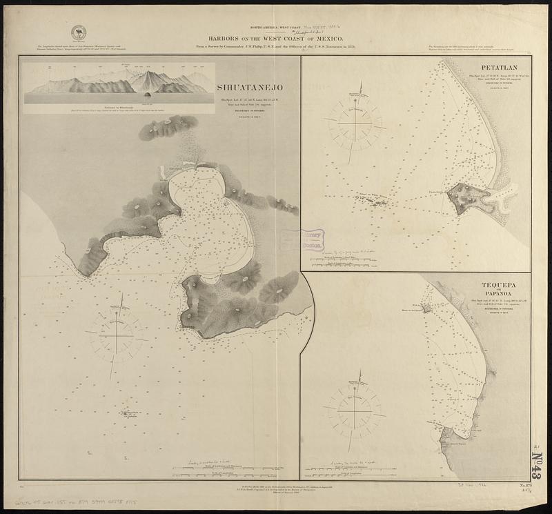
North America, west coast, harbors on the west coast of Mexico : from a survey by Commander J.W. Philip, U.S.N. and the officers of the U.S.S. Tuscarora in 1879
Item Information
- Title:
- North America, west coast, harbors on the west coast of Mexico : from a survey by Commander J.W. Philip, U.S.N. and the officers of the U.S.S. Tuscarora in 1879
- Issuing body:
- United States. Hydrographic Office
- Date:
-
[1888]
- Format:
-
Maps/Atlases
- Genre:
-
Nautical charts
- Location:
-
Boston Public Library
Norman B. Leventhal Map & Education Center - Collection (local):
-
Norman B. Leventhal Map & Education Center Collection
- Subjects:
-
Zihuatanejo Bay (Mexico)--Maps
Potosí Bay (Mexico)--Maps
Tequepa Bay (Mexico)--Maps
Coasts--Mexico--Guerrero (State)--Maps
Nautical charts--Mexico--Zihuatanejo Bay
Nautical charts--Mexico--Potosí Bay
Nautical charts--Mexico--Tequepa Bay
- Places:
-
MexicoGuerreroZihuatanejo, Bahía de (bay)
MexicoGuerreroPotosí, Bahía (bay)
MexicoGuerreroTequepa, Bahía de (bay)
- Extent:
- 3 maps on 1 sheet ; 53 x 64 cm
- Terms of Use:
-
No known copyright restrictions.
No known restrictions on use.
- Publisher:
-
Washington, D.C. :
Hydrographic Office
- Edition:
- Edition of January 1888
- Scale:
-
Scale approximately 1:14,700
Scale approximately 1:24,700
Scale approximately 1:37,000
- Language:
-
English
- Notes:
-
Relief shown by hachures and spot heights. Depths shown by soundings and isolines.
Includes view of Entrance to Sihuatenejo.
- Notes (date):
-
This date is inferred.
- Identifier:
-
06_01_017425
- Call #:
-
G9096.P5 svar .U55 no. 879
- Barcode:
-
39999085958815