Die staten der Balkan-Halbinsel : nach den Grenzbestimmungen des Friedens von Haġios Stephanos (S. Stefano) 3. März 1878
Item Information
- Title:
- Die staten der Balkan-Halbinsel : nach den Grenzbestimmungen des Friedens von Haġios Stephanos (S. Stefano) 3. März 1878
- Title (alt.):
-
Karte der staten auf der Balkan-Halbinsel nach der grenzbestimmungen des Friedens von San Stefano (3. März 1878)
- Cartographer:
- Kiepert, Heinrich, 1818-1899
- Name on Item:
-
H. Kiepert
- Date:
-
1878
- Format:
-
Maps/Atlases
- Location:
-
Boston Public Library
Norman B. Leventhal Map & Education Center - Collection (local):
-
Norman B. Leventhal Map & Education Center Collection
- Subjects:
-
Balkan Peninsula--Administrative and political divisions--19th century--Maps
Balkan Peninsula--Maps
- Places:
-
Balkan Peninsula (area)
- Extent:
- 1 map : color ; 51 x 42 cm, folded to 29 x 24 cm
- Terms of Use:
-
No known copyright restrictions.
No known restrictions on use.
- Publisher:
-
Berlin :
Bei Dietrich Reimer
- Scale:
-
Scale 1:3,000,000
- Language:
-
German
- Notes:
-
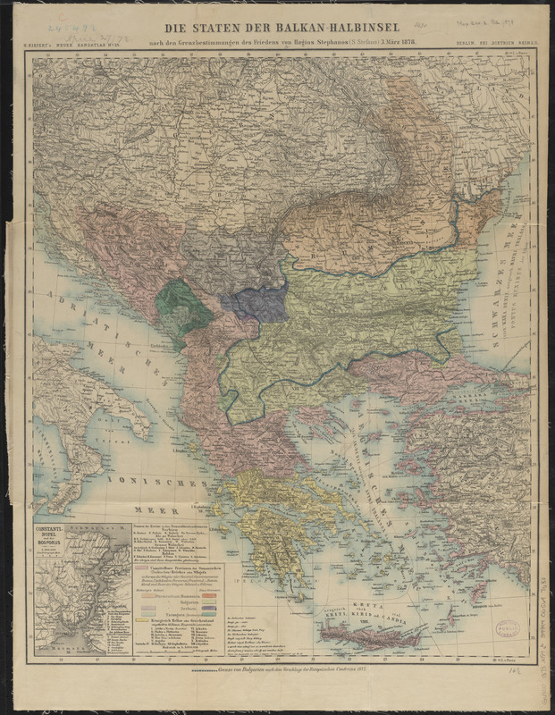
Relief shown by hachures.
Prime meridians: Ferro and Paris.
"H. Kiepert's Neuer Handatlas no. 25"--upper left margin.
Inset map: Constanti-nopel und der Bosporus, scale 1:300,000.
Shows the political boundaries of the Balkan Peninsula.
Boundaries of Bulgaria according to the Constantinople Conference of 1877 outlined in blue.
- Identifier:
-
06_01_012609
- Call #:
-
G6800 1878 .K54
- Barcode:
-
39999065697680


