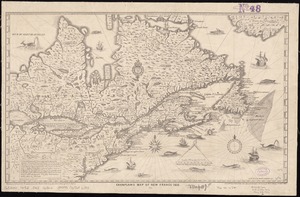
[New France, New Englande, New Scotlande, and Newfoundlande]
![[New France, New Englande, New Scotlande, and Newfoundlande]](https://bpldcassets.blob.core.windows.net/derivatives/images/commonwealth:4m90ff24t/image_access_800.jpg)
Item Information
- Title:
- [New France, New Englande, New Scotlande, and Newfoundlande]
- Creator:
- Stirling, William Alexander, Earl of, 1567 or 1568-1640
- Date:
-
[1880?–1889?]
- Format:
-
Maps/Atlases
- Location:
-
Boston Public Library
Norman B. Leventhal Map & Education Center - Collection (local):
-
Norman B. Leventhal Map & Education Center Collection
- Subjects:
-
Atlantic Provinces--Maps--Early works to 1800--Facsimiles
Canada, Eastern--Maps--Early works to 1800--Facsimiles
New England--Maps--Early works to 1800--Facsimiles
- Places:
-
New England (area)
CanadaNewfoundland and Labrador (province)
- Extent:
- 1 map ; 24 x 32 cm.
- Terms of Use:
-
No known copyright restrictions.
No known restrictions on use.
- Publisher:
-
S.l :
s.n.
- Scale:
-
Scale [ca. 1:6,600,000]
- Language:
-
English
- Notes:
-
Facsimile of the first state, which appeared in An encourageement to colonies, 1624.
Relief shown pictorially.
Title supplied by cataloger.
- Identifier:
-
06_01_011562
- Call #:
-
G3400 1624 .S75 1880
- Barcode:
-
39999065686485