Guide map of Chicago, October 11th, 1871
Item Information
- Title:
- Guide map of Chicago, October 11th, 1871
- Description:
-
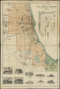
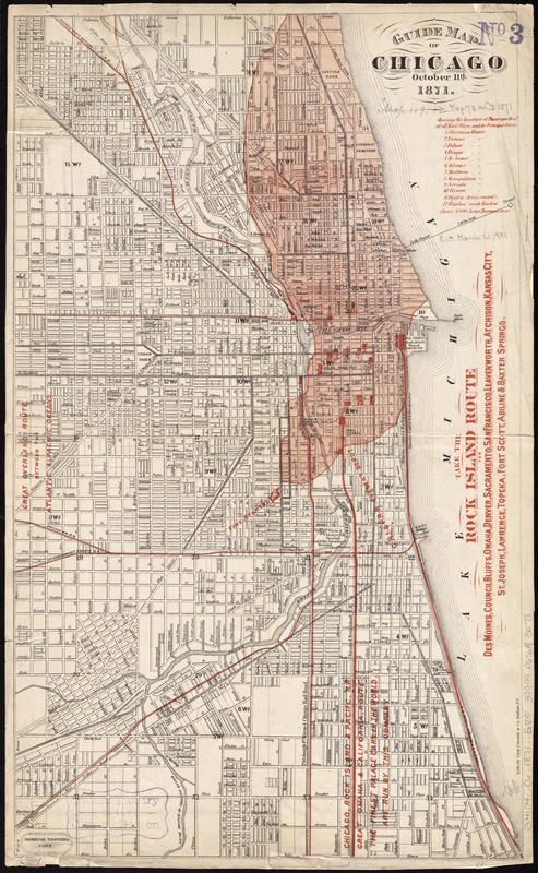
America Transformed: By 1870, Chicago's population approached 300,000, making it the nation's fifth largest city. This guide map, published just after the Great Chicago Fire, superimposes the burned area over the gridded street pattern. The fire started southwest of the city center and burned over 2,000 acres, noted by the shaded red area. A strong southwest wind, wooden structures, and summer drought fueled the flames that left approximately 100,000 people homeless. Though legend suggests that a cow caused the flames by knocking over a lantern, the real cause is unknown. In reaction to the mass destruction, city officials and urban planners lobbied for stricter building codes and better fire-fighting services.
- Creator:
- Clay, Cosack & Co
- Name on Item:
-
lith. by Clay, Cosack & Co.
- Date:
-
[1871]
- Format:
-
Maps/Atlases
- Location:
-
Boston Public Library
Norman B. Leventhal Map & Education Center - Collection (local):
-
Norman B. Leventhal Map & Education Center Collection
- Subjects:
-
Railroads--Illinois--Chicago--Maps
Great Fire, Chicago, Ill., 1871--Maps
Chicago (Ill.)--Maps
- Places:
-
IllinoisCook (county)Chicago
- Extent:
- 1 map : col. ; 47 x 28 cm.
- Terms of Use:
-
No known copyright restrictions.
No known restrictions on use.
- Publisher:
-
Buffalo, N.Y :
Clay, Cosack & Co.
- Scale:
-
Scale [ca. 1:24,000]
- Language:
-
English
- Notes:
-
Red overprint shows extent of 1871 fire, railroads and hotels.
Oriented with north to the upper right.
Includes key to hotels and advertisements for railroads.
- Notes (date):
-
This date is inferred.
- Notes (exhibitions):
-
Exhibited: "America Transformed. Part 2: Homesteads to Modern Cities," organized by the Norman B. Leventhal Map & Education Center at the Boston Public Library, 2019-2020.
- Identifier:
-
06_01_011323
- Call #:
-
G4104.C6 1871 .G85
- Barcode:
-
39999065683078