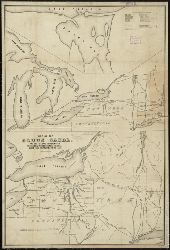
Map of the Sodus Canal, and the internal improvements connecting with it forming the great route from the Atlantic to the Lakes
Item Information
- Title:
- Map of the Sodus Canal, and the internal improvements connecting with it forming the great route from the Atlantic to the Lakes
- Date:
-
[1850–1859]
- Format:
-
Maps/Atlases
- Location:
-
Boston Public Library
Norman B. Leventhal Map & Education Center - Collection (local):
-
Norman B. Leventhal Map & Education Center Collection
- Subjects:
-
Canals--New York (State)--Maps
Sodus Bay (N.Y.)--Maps
New York (State)--Maps
- Places:
-
New YorkWayne (county)Sodus Bay
- Extent:
- 1 map ; 85 x 57 cm.
- Terms of Use:
-
No known copyright restrictions.
No known restrictions on use.
- Publisher:
-
Boston :
B.W. Thayer & Co. lith.
- Scale:
-
Scale [ca. 1,100,000]
- Language:
-
English
- Notes:
-
Shows canals in New York and surrounding states, including the proposed (but not built) Sodus Canal.
Relief shown by hachures.
Ancillary maps: [Great Lakes] -- [Sodus Bay]
Includes tables of distances.
- Notes (date):
-
This date is inferred.
- Identifier:
-
06_01_010725
- Call #:
-
G3801.P5 1850 .M37
- Barcode:
-
39999065676403