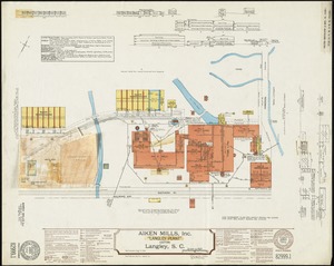
Riverside & Dan River Cotton Mills, Inc. "Dan River Division," Schoolfield, Va. [insurance map]
![Riverside & Dan River Cotton Mills, Inc. "Dan River Division," Schoolfield, Va. [insurance map]](https://bpldcassets.blob.core.windows.net/derivatives/images/commonwealth:2r36vc39h/image_access_800.jpg)
Item Information
- Title:
- Riverside & Dan River Cotton Mills, Inc. "Dan River Division," Schoolfield, Va. [insurance map]
- Description:
-
Associated Mutual Insurance Companies. Riverside & Dan River Cotton Mills, Inc. "Dan River Division," Schoolfield, Va. Boston, Mass.: Associated Mutual Insurance Companies, 1924. Surveyed November 18, 1922. Surveyed by E. P. Pack; drawn and traced by W. G. Harlow. Additional data from Mill, April 28, 1924. 2 sheets. Includes plan of buildings (with dimensions), elevation views of individual buildings (with functions of building floors and rooms), and surroundings. Also includes description of property, power and fuel, stock and product, and extensive description of existing water sources and fire protection resources. Includes side sketch showing power plant at river; and side sketches no. 1 and no.2 showing valve connections (not to scale). Two sheets should be viewed together. Serial number (left sheet) 15504, replaces 11410 (original tracing); serial number (right sheet) 15503, replaces 11409 (original tracing). Index number 45244 (both sheets). Scale 1:960, 1 in. = 80 ft. 53 x 66.5 cm. (each sheet individually); 106 x 66.5 cm. (both sheets together). (OCLC)
- Author:
- Associated Mutual Insurance Companies
- Date:
-
1924
- Format:
-
Maps/Atlases
- Genre:
-
Fire insurance maps
- Location:
- American Textile History Museum
- Collection (local):
-
Osborne Library
- Subjects:
-
Cotton manufacture
Textile factories
Fire risk assessment
Insurance surveys
Riverside & Dan River Cotton Mills, Inc.
Riverside & Dan River Cotton Mills, Inc. Dan River Division (Schoolfield, Va.)
- Places:
-
Danville
- Extent:
- 2 sheets : col. map ; 67 x 53 cm
- Terms of Use:
-
Rights status not evaluated.
Contact host institution for more information.
- Place of origin:
-
Boston, Mass.
- Language:
-
English
- Notes (ownership):
-
The American Textile History Museum closed in 2016. This item has been transferred to the Osher Map Library at the University of Southern Maine.
- Notes (object):
-
Condition: Good - right sheet has residue from pieces pasted on
- Accession #:
-
1994.91.331-332
![Riverside & Dan River Cotton Mills, Inc. "Riverside Division, Mill No. 8" (Cotton Mill), Danville, Va. [insurance map]](https://bpldcassets.blob.core.windows.net/derivatives/images/commonwealth:2r36vc37z/image_thumbnail_300.jpg)
![Acushnet Mill Corp. (Cotton Mill), New Bedford, Mass. [insurance map]](https://bpldcassets.blob.core.windows.net/derivatives/images/commonwealth:ww72bz30x/image_thumbnail_300.jpg)
![American Twine & Fabric Corporation, Bldg., Salmon Falls, N.H. [insurance map]](https://bpldcassets.blob.core.windows.net/derivatives/images/commonwealth:ww72c034d/image_thumbnail_300.jpg)
