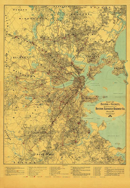
Map of Boston and vicinity, showing tracks operated by the Boston Elevated Railway Co. January, 1910
Item Information
- Title:
- Map of Boston and vicinity, showing tracks operated by the Boston Elevated Railway Co. January, 1910
- Publisher:
- Geo. H. Walker & Co.
- Publisher:
- Walker Lith. & Pub. Co.
- Date:
-
1910
- Format:
-
Maps/Atlases
- Location:
-
Boston Public Library
Norman B. Leventhal Map & Education Center - Collection (local):
-
Norman B. Leventhal Map & Education Center Collection
- Subjects:
-
Local transit--Massachusetts--Boston--Maps
Railroads, elevated--Massachusetts--Boston--Maps
Subways--Massachusetts--Boston--Maps
Boston (Mass.)--Maps
Boston Elevated Railway Company
- Places:
-
MassachusettsSuffolk (county)Boston
- Extent:
- 1 map : color
- Terms of Use:
-
No known copyright restrictions.
No known restrictions on use.
- Publisher:
-
Boston :
Geo. H. Walker & Co.
- Language:
-
English
- Notes:
-
Shows car houses, power stations, transfer points, connecting lines, surface tracks, elevated tracks, tunnel and subway and foreign tracks.
Includes key to 53 numbered places.
- Identifier:
-
1910-Walker-System
- Call #:
-
G3764.B6P33 svar .B67
- Barcode:
-
39999065669267


