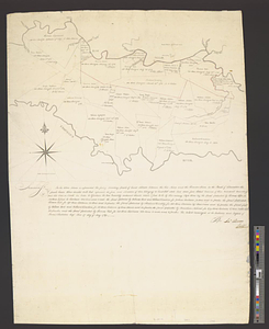
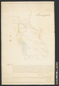
Jamaica Is; Middlesex : the above diagram shows the fixing of sundry plats of land on Teak Savanna Mountains, in the parish of Clarendon
This map is also available in American Revolutionary Geographies Online (ARGO), a collections portal especially built for material relating to the American Revolutionary War Era. Visit ARGO to learn more about this item and explore the historical geography of North America in the late eighteenth century.
Item Information
- Title:
- Jamaica Is; Middlesex : the above diagram shows the fixing of sundry plats of land on Teak Savanna Mountains, in the parish of Clarendon
- Contributor:
- Fraser, P.
- Contributor:
- Frazer, J.
- Contributor:
- Fullerton
- Creator:
- Rome, John
- Date:
-
July 1799
- Format:
-
Maps/Atlases
- Genre:
-
Manuscript maps
- Location:
- William L. Clements Library
- Collection (local):
-
William L. Clements Library Collection
- Subjects:
-
Real property--Jamaica--Middlesex (County)--Maps
Clarendon Parish (Jamaica)--Maps
Middlesex (Jamaica : County)--Maps
Penrhyn, Richard Pennant, Baron, 1737?-1808
Dawkins, Henry
Chisholme, James
- Places:
-
JamaicaClarendon (county)
- Extent:
- 1 ms. map : col. ; 82.6 x 57 cm
- Terms of Use:
-
The University of Michigan Library provides access to these materials for educational and research purposes. These materials may be under copyright. If you decide to use any of these materials, you are responsible for making your own legal assessment and securing any necessary permission. If you have questions about the collection, please contact the William L. Clements Library.
Contact host institution for more information.
- Scale:
-
Scale 1:263,769.
- Language:
-
English
- Catalog Record:
-
Catalog record
- Notes:
-
Survey conducted by two pairs of surveyors on behalf of two groups of owners.
Signed: Rome & Fraser on behalf of Jas Chisholme esq [and] Frazer & Fullerton surveyors for the Right Honorable Lord Penrhyn and Henry Dawkins esqr.
Gives property owners' names on most nearby plots.
- Identifier:
-
8725
- Barcode:
-
B1937125