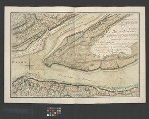
Parish of St. Charles
This map is also available in American Revolutionary Geographies Online (ARGO), a collections portal especially built for material relating to the American Revolutionary War Era. Visit ARGO to learn more about this item and explore the historical geography of North America in the late eighteenth century.
Item Information
- Title:
- Parish of St. Charles
- Date:
-
[ca. 1761]
- Format:
-
Maps/Atlases
- Genre:
-
Manuscript maps
- Location:
- William L. Clements Library
- Collection (local):
-
William L. Clements Library Collection
- Subjects:
-
Lévis (Québec)--Maps
United States--History--French and Indian War, 1754-1763--Maps
- Places:
-
CanadaQuebec (province)Lévis
- Extent:
- 1 ms. map : col. ; 50 x 71.3 cm.
- Terms of Use:
-
The University of Michigan Library provides access to these materials for educational and research purposes. These materials may be under copyright. If you decide to use any of these materials, you are responsible for making your own legal assessment and securing any necessary permission. If you have questions about the collection, please contact the William L. Clements Library.
Contact host institution for more information.
- Scale:
-
Scale 1:24,000.
- Language:
-
English
- Catalog Record:
-
Catalog record
- Notes:
-
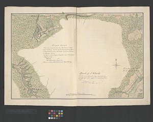
Finished, colored, topographical map showing the buildings, farms and roads of the area.
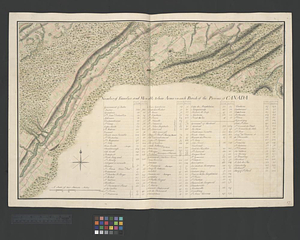
Map sheet includes a table titled: Number of families and men able to bear arms in each Parish of the Province of Canada. The table collects listed numbers from all 68 map sheets of the Murray Atlas of Canada. The table includes numbers for the Parish of St. Charles which does not have its own legend.
Map corresponds with 16 other maps as well as title page sheet 50 and key map sheet 49.
Map is sheet 68 of the Murray Atlas of Canada and sheet 17 of its series.
- Identifier:
-
726
- Barcode:
-
B7466903