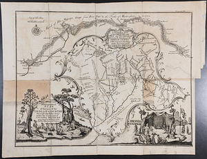
Plan of the Indian countrys through which the troops marchd in 1764 under the command of Col. Henry Bouquet

This map is also available in American Revolutionary Geographies Online (ARGO), a collections portal especially built for material relating to the American Revolutionary War Era. Visit ARGO to learn more about this item and explore the historical geography of North America in the late eighteenth century.
Item Information
- Title:
- Plan of the Indian countrys through which the troops marchd in 1764 under the command of Col. Henry Bouquet
- Contributor:
- Ratzer, Bernard
- Creator:
- Hutchins, Thomas, 1730-1789
- Date:
-
[1765]
- Format:
-
Maps/Atlases
- Genre:
-
Manuscript maps
- Location:
- William L. Clements Library
- Collection (local):
-
William L. Clements Library Collection
- Subjects:
-
Pontiac's Conspiracy, 1763-1765--Maps
Bouquet's Expedition, 1764--Maps
Ohio--Maps
Pennsylvania--Maps
- Places:
-
Ohio
Pennsylvania
- Extent:
- 1 ms. map : col. ; 49 x 142.1 cm.
- Terms of Use:
-
The University of Michigan Library provides access to these materials for educational and research purposes. These materials may be under copyright. If you decide to use any of these materials, you are responsible for making your own legal assessment and securing any necessary permission. If you have questions about the collection, please contact the William L. Clements Library.
Contact host institution for more information.
- Scale:
-
Scale 1:130,000.
- Language:
-
English
- Catalog Record:
-
Catalog record
- Notes:
-
Copied from original by Lieutenant Ratzer.
Finished, colored, topographical strip map showing the route of march of Bouquet's army in 1764 from Fort Pitt to the Muskingum River.
Indian towns and encampments and route of march of the army are identified.
Copied from Thomas Hutchins's map, which was itself engraved and published in 1765 as part of "A topographical plan of that part of the Indian country ..."
- Notes (date):
-
This date is inferred.
- Identifier:
-
866
- Barcode:
-
B2384789