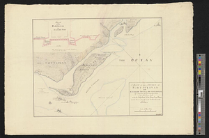
A plan of the attack of Fort Sulivan near Charles Town in South Carolina by a squadron of his majesty's ships on the 28 June 1776 with the disposition of the king's land forces and the encampments & entrenchments of the Americans from the drawing made on the spot
This map is also available in American Revolutionary Geographies Online (ARGO), a collections portal especially built for material relating to the American Revolutionary War Era. Visit ARGO to learn more about this item and explore the historical geography of North America in the late eighteenth century.
Item Information
- Title:
- A plan of the attack of Fort Sulivan near Charles Town in South Carolina by a squadron of his majesty's ships on the 28 June 1776 with the disposition of the king's land forces and the encampments & entrenchments of the Americans from the drawing made on the spot
- Title (alt.):
-
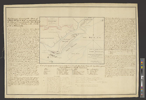
Plan of the platform of Sulivans fort by Lt. Colonel Thos James of the Royal Regiment of Artillery
- Date:
-
[ca. 1778]
- Format:
-
Maps/Atlases
- Genre:
-
Manuscript maps
- Location:
- William L. Clements Library
- Collection (local):
-
William L. Clements Library Collection
- Subjects:
-
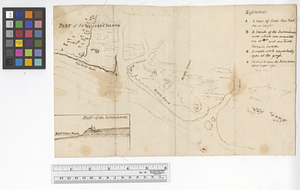
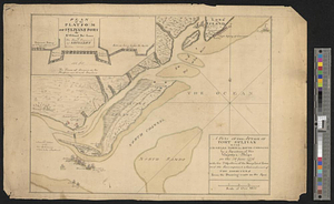
Fort Moultrie (S.C.)--Maps
Sullivan's Island (S.C. : Island)--Maps
Charleston (S.C.)--History--Siege, 1776--Maps
United States--History--Revolution, 1775-1783--Maps
- Places:
-
South CarolinaCharleston (county)Sullivan's Island (island)
South CarolinaCharleston (county)Charleston
South CarolinaCharleston (county)Fort Moultrie
- Extent:
- 1 ms. map : col. ; 28 x 38 cm
- Terms of Use:
-
The University of Michigan Library provides access to these materials for educational and research purposes. These materials may be under copyright. If you decide to use any of these materials, you are responsible for making your own legal assessment and securing any necessary permission. If you have questions about the collection, please contact the William L. Clements Library.
Contact host institution for more information.
- Scale:
-
Scale 1:26,000.
- Language:
-
English
- Catalog Record:
-
Catalog record
- Notes:
-
Finished, colored, topographical map copied from a printed map of the same title with only the substitution of the word American for Rebel.
- Identifier:
-
8389
- Barcode:
-
B1938748