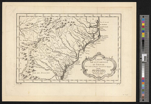
A map of the sea coast of Georgia & the inland parts thereof extending to the westward of that part of Savannah called Broad River including the several inlets, rivers, islands, sounds, creeks, rivulets, towns, roads, forts & most remarcable places therein : performed at the request of his exclly. James Wright esqr. captn. genl. & governor in chief of the said province the 20th day of August 1763 & in the third year of the reign of his majesty King George III
This map is also available in American Revolutionary Geographies Online (ARGO), a collections portal especially built for material relating to the American Revolutionary War Era. Visit ARGO to learn more about this item and explore the historical geography of North America in the late eighteenth century.
Item Information
- Title:
- A map of the sea coast of Georgia & the inland parts thereof extending to the westward of that part of Savannah called Broad River including the several inlets, rivers, islands, sounds, creeks, rivulets, towns, roads, forts & most remarcable places therein : performed at the request of his exclly. James Wright esqr. captn. genl. & governor in chief of the said province the 20th day of August 1763 & in the third year of the reign of his majesty King George III
- Contributor:
- De Brahm, John Gerar William, 1717-approximately 1799
- Creator:
- Yonge, Henry
- Name on Item:
-
by Henry Yonge, JGW De Brahm surs. genl.
- Date:
-
1763
- Format:
-
Maps/Atlases
- Genre:
-
Manuscript maps
- Location:
- William L. Clements Library
- Collection (local):
-
William L. Clements Library Collection
- Subjects:
-
Georgia--Maps
- Places:
-
Georgia
- Extent:
- 1 ms. map : outline col. ; 34 x 60.6 cm.
- Terms of Use:
-
The University of Michigan Library provides access to these materials for educational and research purposes. These materials may be under copyright. If you decide to use any of these materials, you are responsible for making your own legal assessment and securing any necessary permission. If you have questions about the collection, please contact the William L. Clements Library.
Contact host institution for more information.
- Scale:
-
Scale 1:550,000.
- Language:
-
English
- Catalog Record:
-
Catalog record
- Notes:
-
Finished, topographical map on vellum.
Colored boundary lines identify land ceded by the Indians to General Oglethorpe in 1759 and to Governor Wright in 1763.
Land cessions are explained in a note.
Clinton Maps 329.
- Identifier:
-
561
- Barcode:
-
B2640351