Introduction
In 1891 landscape architect, Charles Eliot asserted the bold idea to form an organization that would preserve, for public use and enjoyment, properties of exceptional scenic, historic, and ecological value in Massachusetts. At a time when land conservation and ‘being green’ was not widely discussed, his vision was forward thinking. Today, the organization he founded, The Trustees of Reservations, oversees more than 26,000 acres of preserved places from the Atlantic Coast to the Berkshire Mountains.
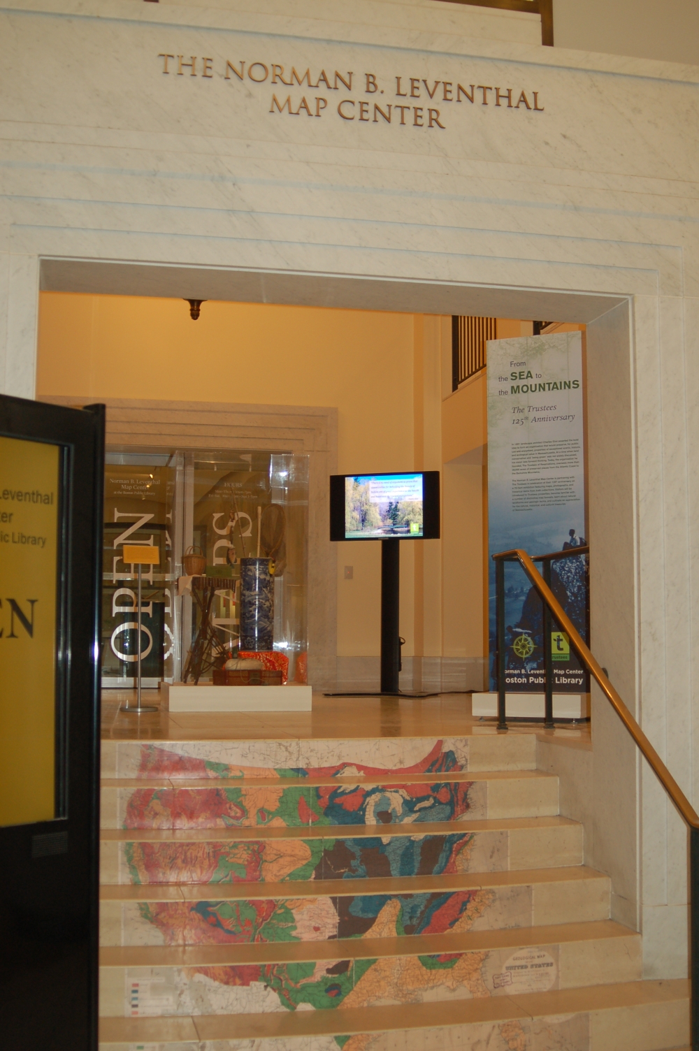
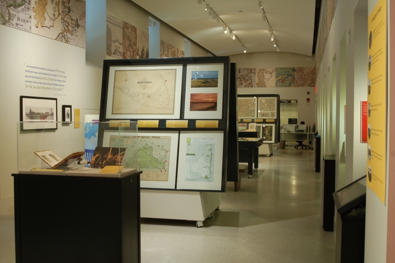
The Norman B. Leventhal Map Center at the Boston Public Library is partnering with The Trustees in celebration of their 125th Anniversary on a 70-item exhibition, featuring maps, photographs, and historical items from both collections. Visitors will be introduced to Trustees properties, become familiar with a number of distinctive map formats, learn about natural landforms and geologic terms, and cultivate an appreciation for the natural, historical, and cultural treasures of Massachusetts.
1. The Trustees
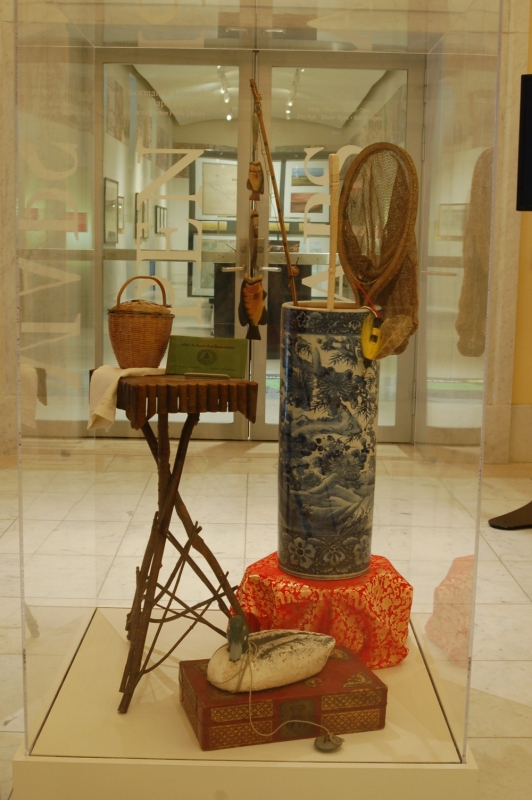

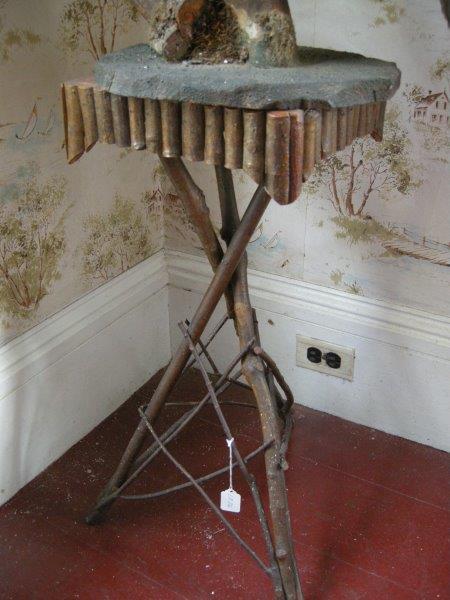
- Rustic Table. Ca. 1920. Lyman Reserve Collection, The Trustees. Bourne, Plymouth, and Wareham, MA.
- Berry Basket. Ca. 1870. William Cullen Bryant Homestead Collection, The Trustees. Cummington, MA.
- The Trustees of Reservations . How to Reach Our Reservations. Boston, 1936. Archives & Research Center, The Trustees. Sharon, MA.
- Umbrella Stand. Ca. 1920. Stevens-Coolidge Place Collection, The Trustees. North Andover, MA.
- Ice Fishing Rod. Ca. 1980. Lyman Reserve Collection, The Trustees. Bourne, Plymouth, and Wareham, MA.
- Bone Cane. Ca. 1880. Appleton Farms Collection, The Trustees. Hamilton and Ipswich, MA.
- Fishing Dip Net. Ca. 1920. Lyman Reserve Collection, The Trustees. Bourne, Plymouth, and Wareham, MA.
- Accessory Box. Ca. 1940. Greenwood Farm Collection, The Trustees. Ipswich, MA.
- Duck Decoy. Ca. 1950. Lyman Reserve Collection, The Trustees. Bourne, Plymouth, and Wareham, MA.
- Fishing Lure. Ca. 1940. Lyman Reserve Collection, The Trustees. Bourne, Plymouth, and Wareham, MA.
The Trustees care for more than 100 properties—which includes 26,000 acres of land and 11 historical houses — throughout the state of Massachusetts, from coastal sites in the east, to mountainous locales in the west. The items displayed here reflect the unique character of these diverse places, and illustrate different pursuits undertaken by former residents. Duck decoys and fishing equipment reveal the waterfowl hunting and angling history of coastal properties, while a berry basket once owned by poet William Cullen Bryant evokes the pastoral landscape of western Massachusetts. Luxury items, such as a carved bone cane and Chinese export porcelain, and repurposed objects like a tennis racket made for fishing, speak to the contrasting opulent and humble natures of the sites.
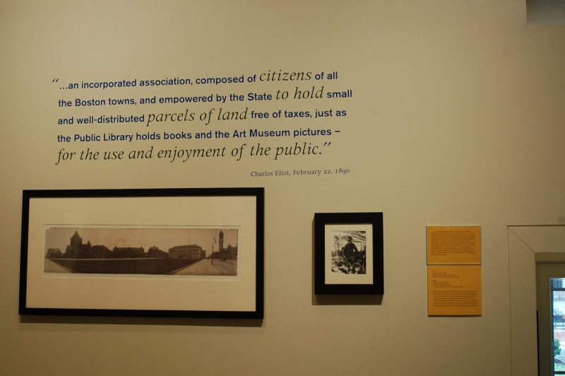
“…an incorporated association, composed of citizens of all the Boston towns, and empowered by the State to hold small and well-distributed parcels of land free of taxes, just as the Public Library holds books and the Art Museum pictures – for the use and enjoyment of the public.”
-Charles Eliot, February 22, 1890
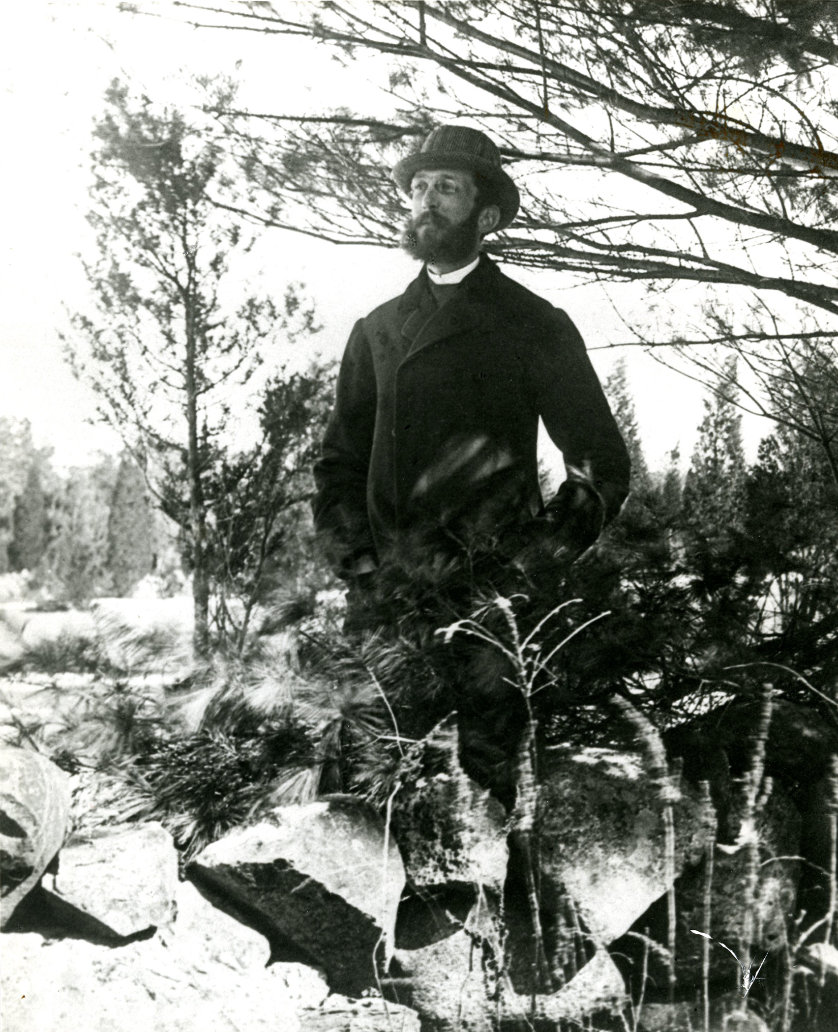
Charles Eliot, 1859-1897
Ca. 1895. Digital print, 2016.
Courtesy of the Carola Eliot Goriansky Family.
Pioneering landscape architect Charles Eliot (1859-1897) appealed to the general public in his famous Waverly Oaks letter – excerpted above. Just one year later, Eliot’s letter became the catalyst for a movement that convinced the Massachusetts State Legislature to establish The Trustees of Public Reservations, a member supported organization. Eliot’s vision was to preserve the natural, scenic landscapes in the state, make these places accessible to all residents, and improve upon them, thereby enhancing the lives of current and future generations. Today, 125 years later, the organization he founded oversees and provides public access to more than 26,000 acres in 114 preserved places from Cape Cod to the Berkshires, as well as 11 historic houses, more than 30,000 objects, 72 archaeological sites, and 291 buildings.
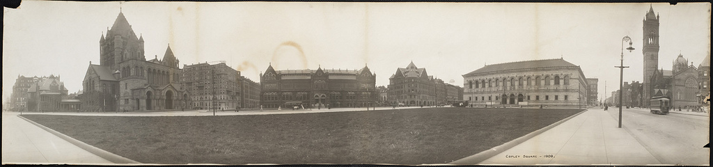
Copley Square—1909
[Boston, 1909]. Digital print, 2016.
Boston Public Library, Print Department.
The panoramic photograph displayed here shows Copley Square as it looked in the early 20th Century – not long after Eliot established The Trustees. Taken from the corner of Boylston and Clarendon Streets, this image documents the buildings that once stood in the Square, which was considered the “hub” of cultural institutions, including the Museum of Fine Arts, Trinity Church, and the Boston Public Library.
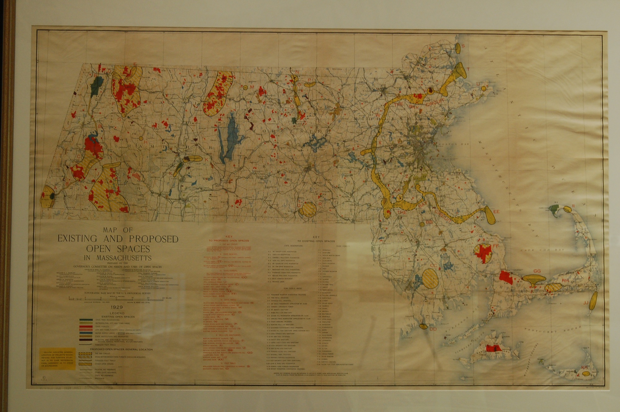
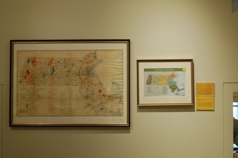
Massachusetts. Committee on Needs and Uses of Open Spaces
Map of Existing and Proposed Open Spaces in Massachusetts
Boston, 1929.
Norman B. Leventhal Map Center at the Boston Public Library.
By 1929, The Trustees maintained eight properties. At that time, the Governor of Massachusetts established the Committee on Needs and Uses of Open Spaces to develop a plan to “meet present and future public needs” related to the preservation of open spaces. The expertise of The Trustees in this area is indicated by the number of representatives on this Open Space Committee. Existing state reservations, forests, and semi-public areas are illustrated in green, red, blue and brown, while proposed open spaces are in yellow. These suggested areas included the Bay Circuit in the east, Lake Chaubunagungamaug in Webster, and October Mountain in Lee.
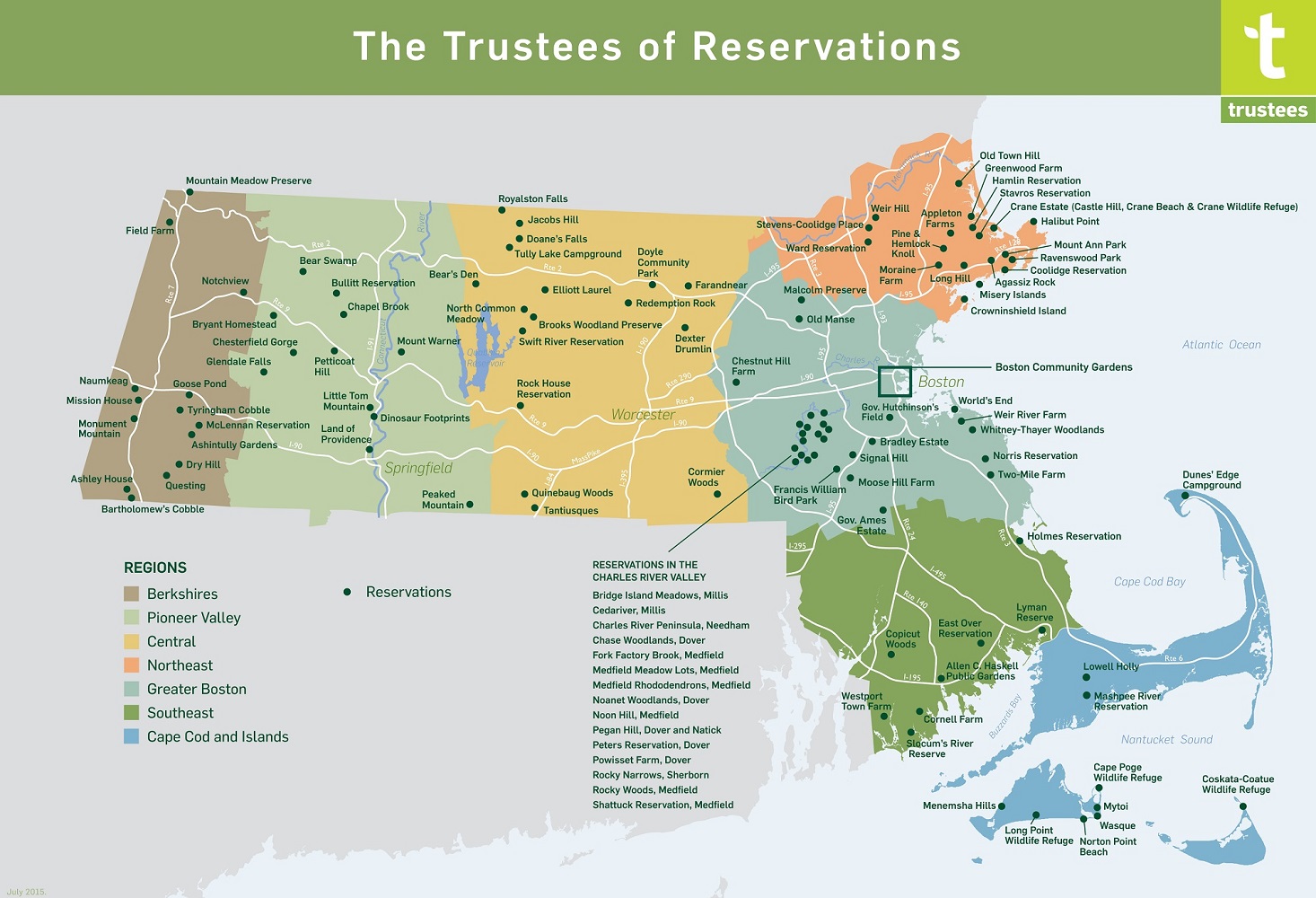
Vincent Antil – GIS Manager, The Trustees
Regional Property Guide
Leominster, MA, 2015.
The Trustees.
Today, The Trustees care for more than 100 places throughout Massachusetts – from the coasts of Nantucket to the mountains of the Berkshires. Their varied properties consist of natural landscapes — including beaches, forests and mountains, — farmhouses and their lands, and stately historic homes. A wide range of activities are available at the sites, which are intended to be actively used by visitors. The map displayed here indicates the location of each of the properties.
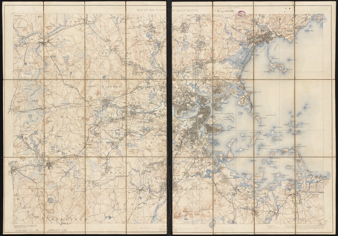
Appalachian Mountain Club
Map of the Country About Boston
Boston, 1890.
Norman B. Leventhal Map Center at the Boston Public Library.
The Appalachian Mountain Club (AMC), an organization of outdoor enthusiasts, was founded in Boston in 1876. Charles Eliot was an early member of the Club, and in 1890 was elected Councilor of Topography – the same year he petitioned his fellow members to discuss the notion of The Trustees of Public Reservations. The map displayed here was published under Eliot’s guidance, and used topographic maps produced by government agencies to illustrate the varied terrain surrounding Boston. Eliot and the AMC continued with their conservation efforts, and in 1892 established the Metropolitan Park Commission, the nation’s first regional park system.
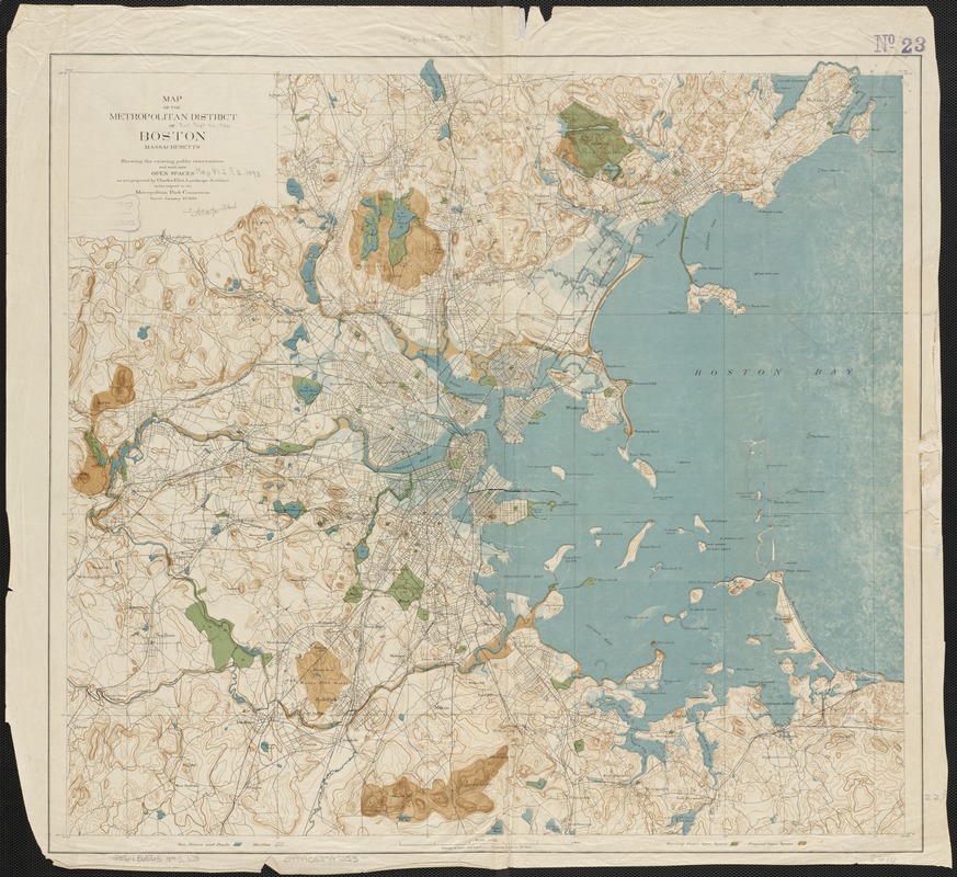
Charles Eliot (1859-1897)
Map of the Metropolitan District of Boston, Massachusetts: Showing the Existing Public Reservations and Such New Open Spaces as are Proposed by Charles Eliot …
Boston, 1893.
Norman B. Leventhal Map Center at the Boston Public Library.
This 1893 map was included in Charles Eliot’s report to the newly formed Metropolitan Park Commission (the forerunner of the DCR). The Commission was dedicated to preserving green spaces within a ten-mile radius of Boston. Due to a surging immigrant population and chaotic development in the late 19th Century, open space was disappearing at an alarming rate. As the Commission’s first landscape architect, Eliot declared “ …crowded populations, if they would live in health and happiness, must have space for air, for light, for exercise, for rest, and for the enjoyment of that peaceful beauty of nature …” This topographic map illustrates the open spaces he hoped to protect.
2. Boston Region
Boston Gardens Property Guide
Leominster, MA, 2015.
The Trustees.

Jeremy Dick – Stewardship Manager, The Trustees
Elnora Thompson and Karen Chaffee, Nightingale Community Garden
Boston, Massachusetts, 2011. Digital print, 2016.
The Trustees.

Jeremy Dick – Stewardship Manager, The Trustees
Vegetables in Summer
Boston, Massachusetts, 2011. Digital print, 2016.
The Trustees.
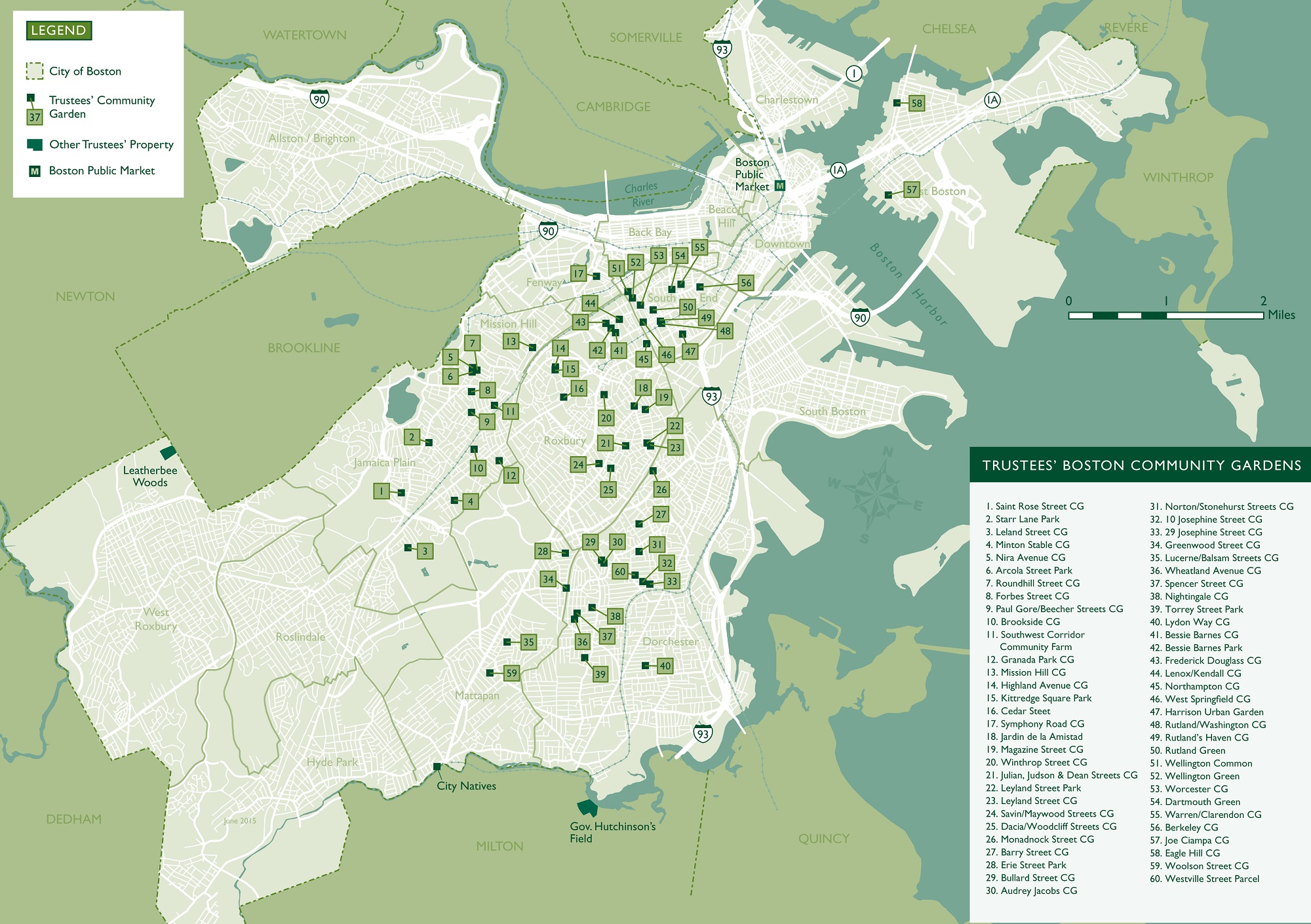
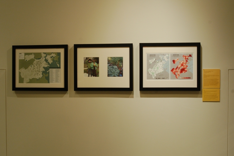
The Trustees’ Boston community gardens are living, growing retreats in otherwise built, urban neighborhoods. They are gathering spaces in their communities, providing people with access to fresh food and the outdoors. This map illustrates the 56 community gardens managed by The Trustees throughout the city. With origins in the 1970s grassroots movement, amid a time of racial division and tension in Boston, these gardens continue as symbols of neighborhood advocacy and promote inclusion. Transcending culture, race, age, and economic status, Bostonians come together to work these special places. The photographs displayed here demonstrate how garden volunteers work the land and reap the benefits at harvest time.
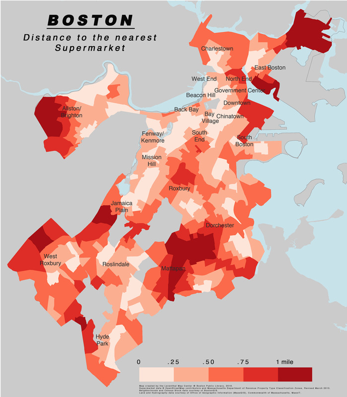
Norman B. Leventhal Map Center at the Boston Public Library
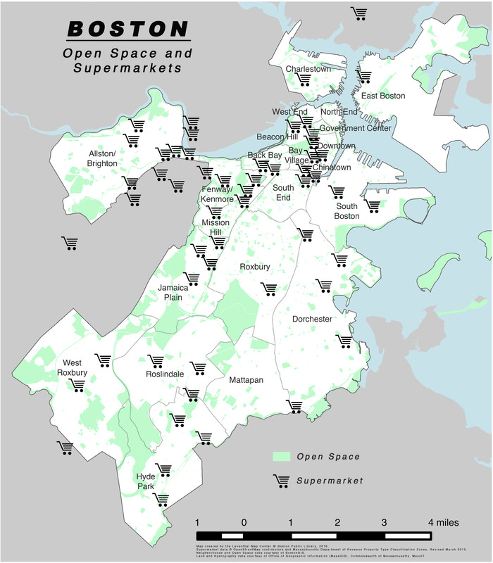
Open Space and Supermarkets and Distance to the Nearest Supermarket
Leominster, MA, 2015
Access to fresh, nutritious food is a major benefit of the gardens, particularly in neighborhoods where supermarkets are low in number. Locations of supermarkets throughout the city and distances to the nearest markets are plotted on these maps. Using Geographic Information Systems (GIS), the maps displayed here allow viewers to visualize geographically referenced data – such as the locations of community gardens or supermarkets. Massachusetts has fewer supermarkets per capita than almost any state in the country (ranking 48th).
3. Cape Cod and the Islands
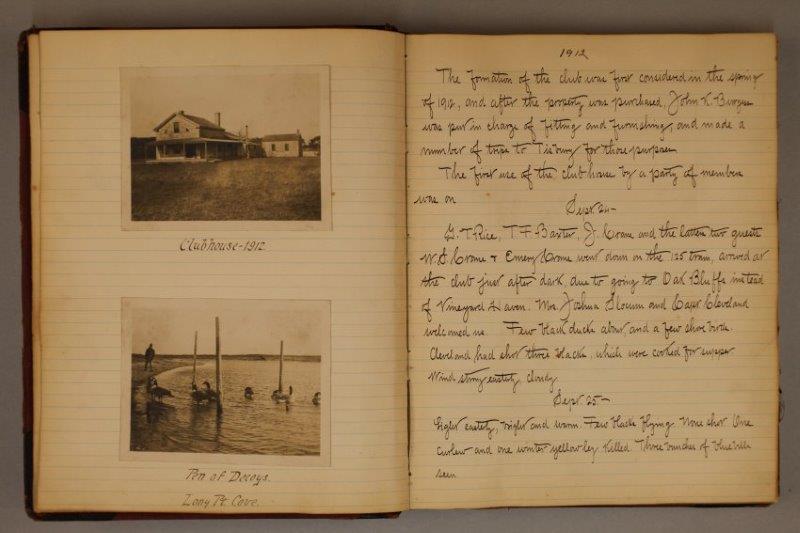
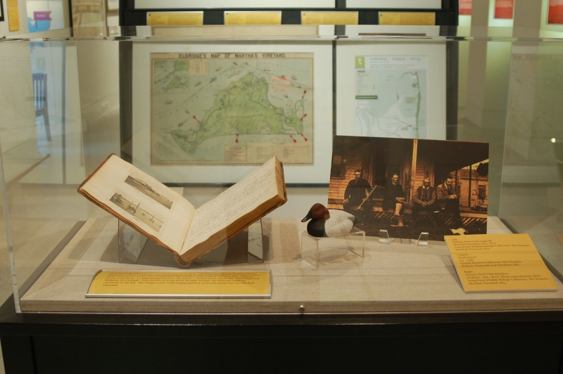
Tisbury Pond Club Logbook
Martha’s Vineyard, Massachusetts , 1912.
Long Point Wildlife Refuge Collection, The Trustees.
Martha’s Vineyard, MA.

Duck Decoy
Ca. 1940.
Lyman Reserve Collection, The Trustees.
Bourne, Plymouth and Wareham, MA.
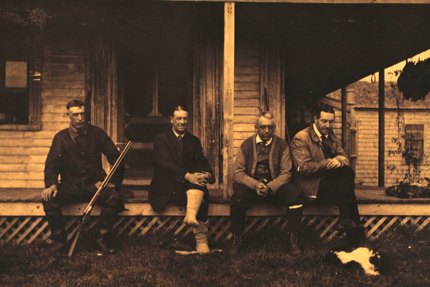
Tisbury Pond Club Members
[Tisbury, Massachusetts, 1913]. Photo reproduction, 2016.
Long Point Wildlife Refuge Collection, The Trustees.
Martha’s Vineyard, MA.
Established in 1912, the Tisbury Pond Club on Martha’s Vineyard was a seasonal retreat for a group of wealthy Bostonians interested in duck hunting. Club members purchased abandoned farms and created nearly 500 acres of hunting ground. A tally page in the logbook gives an accounting of a seven-year period where the members had 47 bird shooting days, bagging nearly 2,000 birds. 13 different species were identified — Buffalohead, Sheldrake, Yellowlegs and Baldpate, for example. Now known as Long Point Wildlife Refuge, the hunting tradition continues in the fall. The refuge is one of the largest publicly accessible properties on Martha’s Vineyard.
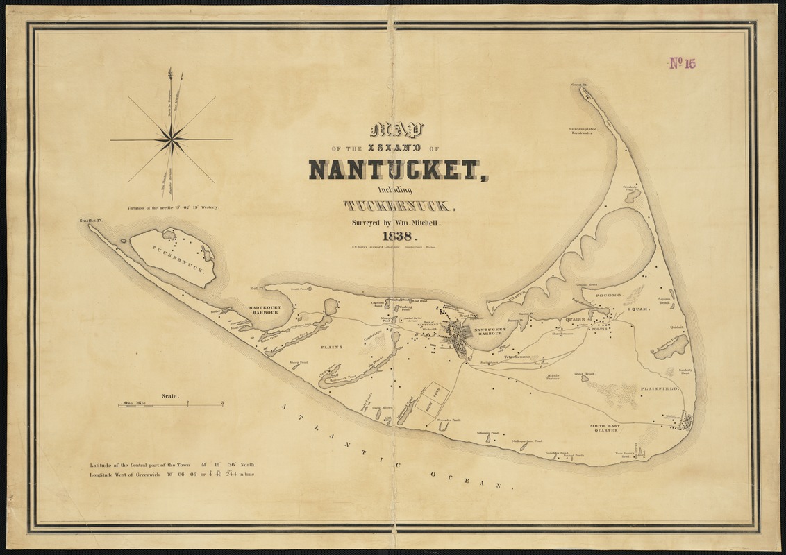
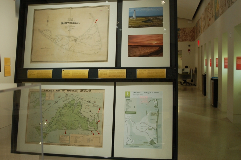
William Mitchell (1791-1868)
Map of the Island of Nantucket, Including Tuckernuck
Boston, 1838
Norman B. Leventhal Map Center at the Boston Public Library.
The island of Nantucket is home to the easternmost site cared for by The Trustees. Coskata-Coatue Wildlife Refuge, located on two peninsulas on the northeast coast of the island, is both a popular destination for vacationers and fishermen, as well as endangered bird species like the Northern Harrier, piping plover, least tern and oystercatcher. The 1838 map by Nantucket astronomer William Mitchell displayed here lists the area as “Coatue” and “Croskaty Pond,” names deriving from two Wampanoag terms given by the island’s original Native American inhabitants. Early 17th-century settlers established themselves in the interior of the island rather than on the coast.
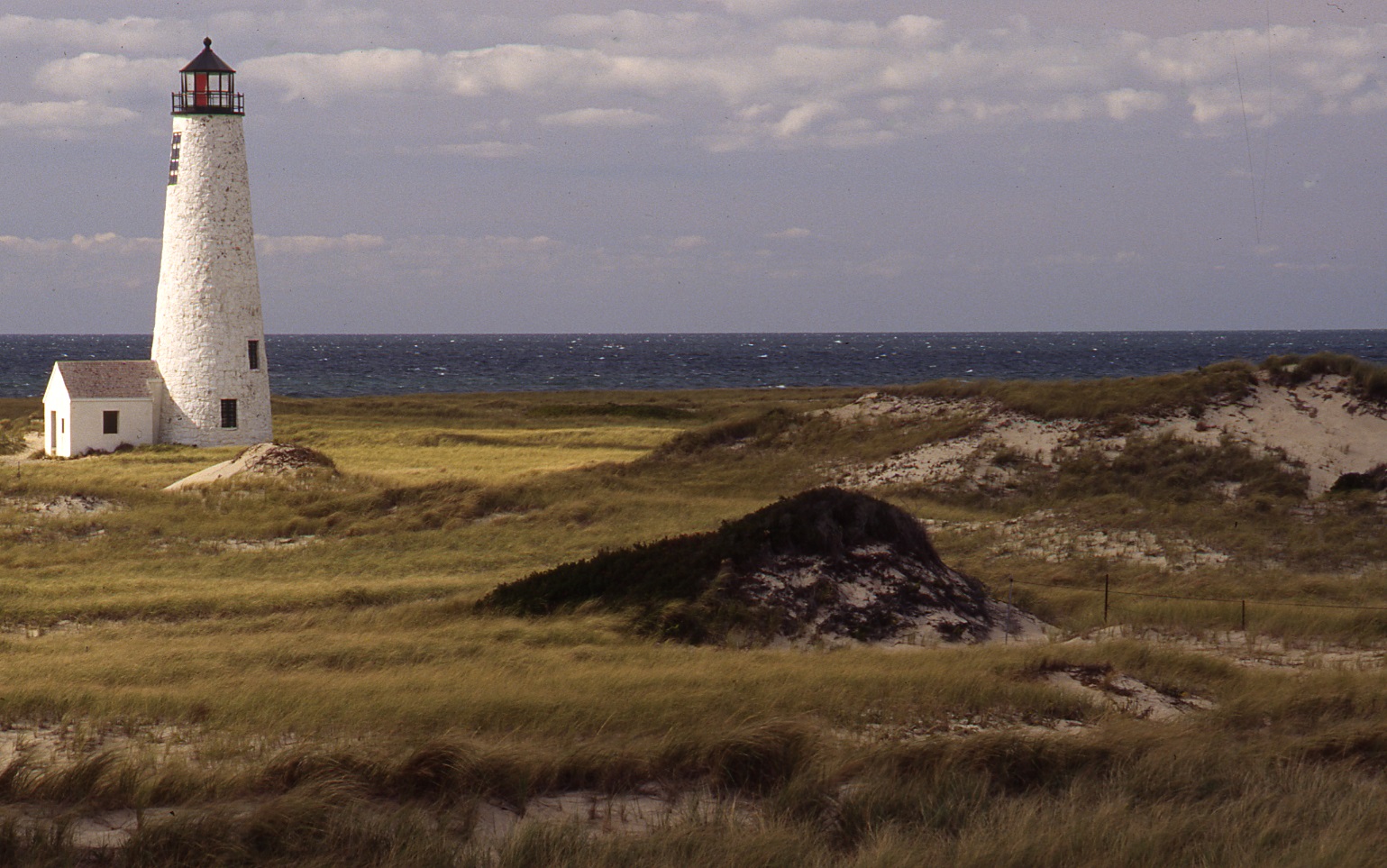
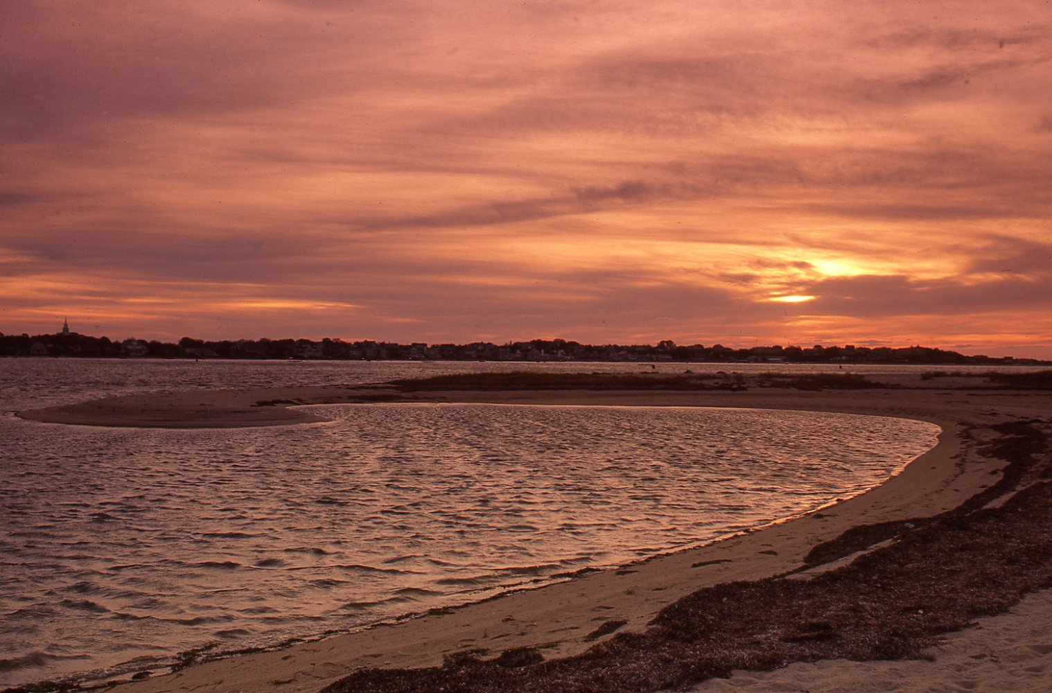
Richard Cheek
“Coatue Point Lighthouse” and “Sunset at Coskata-Coatue Wildlife Refuge,” from Land of the Commonwealth
Beverly, MA, 2000. Silver halide print.
Courtesy Richard Cheek.
From its earliest days, The Trustees realized that saving coastal properties from development was an urgent necessity. Great Point Lighthouse is located within the 20-acre Nantucket National Wildlife Refuge that was created in the mid-1900s to protect migrating waterfowl (black duck, Canada geese, mallards, pintails, etc.). Twice a year migrating birds pass through Nantucket. The unique landscape is made up of sandy beaches, grassy dunes, and forests – providing a habitat for shorebirds, seals, a maritime oak forest, a savannah of red cedar, and many more species.
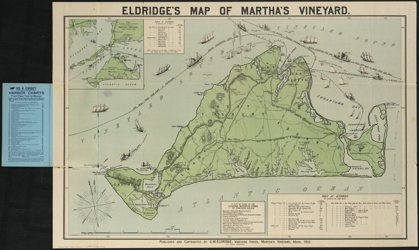
George Eldridge (1821- 1900)
Eldridge’s Map of Martha’s Vineyard
Vineyard Haven, MA, 1913.
Norman B. Leventhal Map Center at the Boston Public Library.
The Trustees have six reservations totaling more than 1,800 acres on the islands of Martha’s Vineyard and Chappaquiddick. Cape Poge Wildlife Refuge, Wasque and Mytoi are found on the Vineyard’s easternmost region – Chappaquiddick Island – while Norton Point Beach, Long Point Wildlife Refuge and Menemsha Hills are located on the main island. This 1913 tourist map of Martha’s Vineyard depicts the diverse landscapes, made up of woodlands, hills, marshes, beaches and gardens. Some of the map’s locations are easily recognizable by name, as they are based on natural features or original Native American titles.
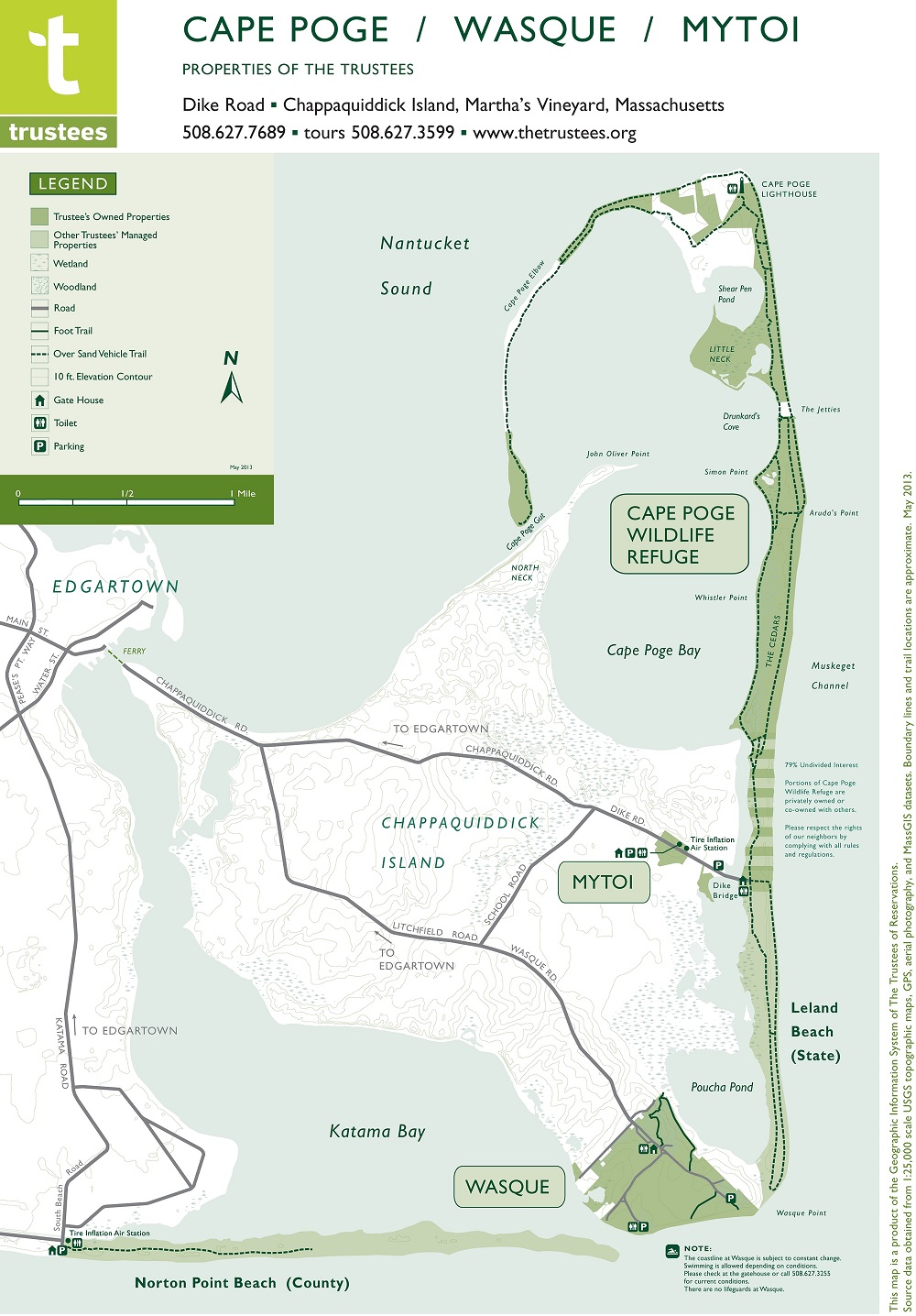
Vincent Antil – GIS Manager, The Trustees
Trail Map of Cape Poge, Wasque and Mytoi
Leominster, MA, 2013. Digital print, 2016.
The Trustees.
Chappaquiddick Island, on eastern Martha’s Vineyard, is home to three very unique Trustees properties. Cape Poge, on the northern tip of the island, provides more than 500 acres of refuge for a variety of plant and animal species. Visitors come to hike, fish, and explore the Cape Poge Lighthouse at the northernmost tip of the sand barrier. Mytoi, an intimate Japanese garden, provides a peaceful spot for those looking to contemplate the beauty of nature, while Wasque – the point on the Vineyard’s southeast corner – is always being dramatically re-shaped due to ocean currents and shifting sands.
4. Southeast Coast
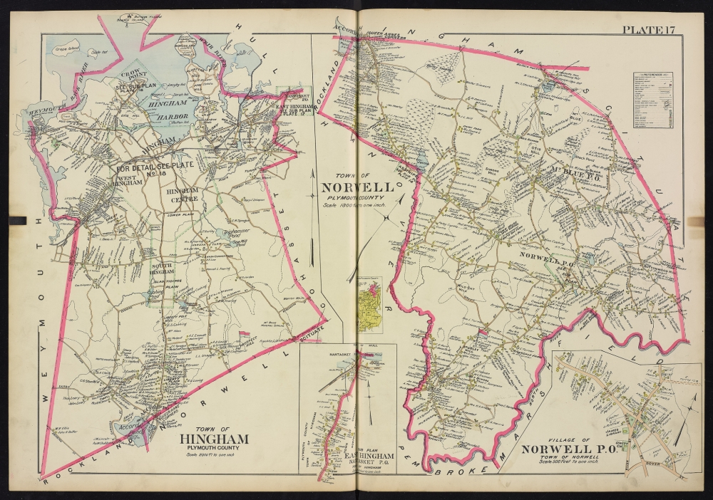
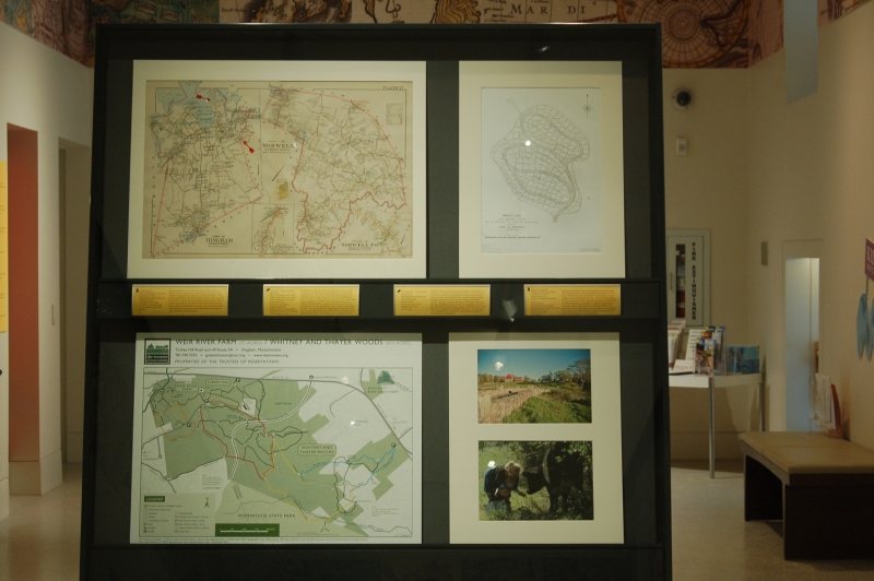
L.J. Richards Co.
“Town of Hingham, Plymouth County,” from New Topographical Atlas of Surveys, Plymouth County
Springfield, MA, 1903.
Norman B. Leventhal Map Center at the Boston Public Library.
Part of the Boston Harbor Islands National Recreation Area, World’s End in Hingham has a rich history and is one of The Trustees unique places on the coast southeast of Boston. There are sweeping views of the Boston skyline, only 15 miles away. In the mid-19th century, Boston businessman John Brewer built an estate on the property. By 1890, Brewer had acquired much of the peninsula, as illustrated on the map seen here, and he hired famed landscape architect Frederick Law Olmsted to design a large subdivision on the property.
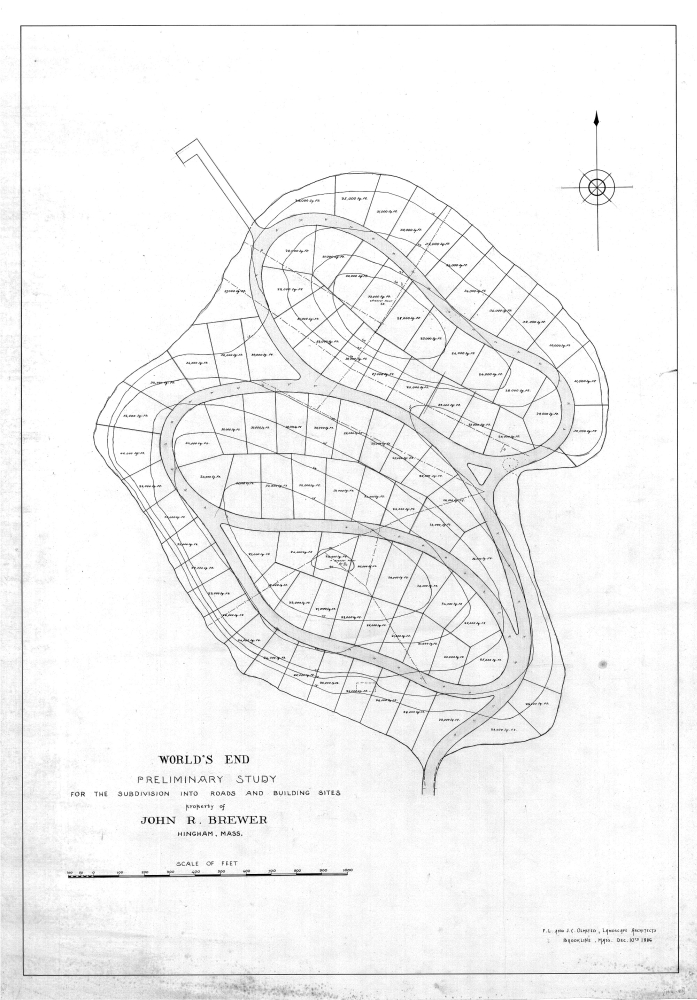
Frederick L. Olmsted (1822-1903) and John C. Olmsted (1852-1920)
World’s End: Preliminary Study for the Subdivision into Roads and Building Sites
Brookline, MA, 1886. Digital print, 2016.
Courtesy of the National Park Service, Frederick Law Olmsted National Historic Site.
Frederick Law Olmsted’s plan divided the peninsula into 163 house lots, surrounded by carriage paths and a “picturesque” landscape style. His 1886 site plan illustrates the design. The stonewalls and carriage paths were built but the development never occurred. Carriage paths are shown here and in the larger map of Hingham. Once a threatened landscape, World’s End survived 20th-century proposals to construct the headquarters for the United Nations and a nuclear power plant. In 1967, residents of Hingham, neighboring communities and The Trustees united financially to preserve the property for generations to come. Today, nature lovers enjoy its 250 acres.
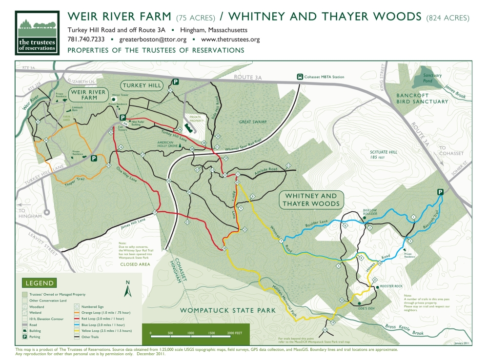
Vincent Antil – GIS Manager, The Trustees
Trail Map of Weir River Farm and Whitney and Thayer Woods
Leominster, MA, 2013. Digital print, 2016.
The Trustees.
Weir River Farm is one of the last remaining working farms in Hingham. This family-friendly site located on 75 acres consists of an iconic red barn surrounded by pastures and woodlands. As this modern trail map illustrates, numerous paths meander through the farm and lead to nearby Whitney and Thayer Woods. The farm entrance atop Turkey Hill, seen here and in the map of Hingham, reveals the topography of the area, and a beautiful view of Boston – a source of inspiration for artist and former property owner, Polly Thayer Starr. Her paintings and drawings have been exhibited and admired in museums from Boston to Philadelphia.
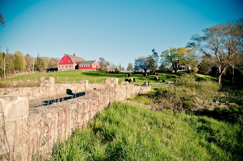
Meg B Photography
Red Barn at Weir River Farm
Hingham, MA, 2015. Digital print, 2016.
Courtesy Meg B Photography.
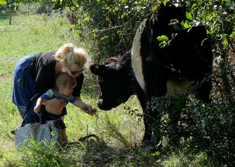
Mark Gardner
Feeding the Belted Galloway – Mother and Son, Weir River Farm
Hingham, Massachusetts, 2015. Digital print, 2016.
The Trustees.
The barn at Weir River Farm is home to livestock such as pigs, cows and sheep, and is often photographed and painted by the locals. Polly Thayer Starr, in addition to being a portrait artist, regularly sketched and drew the cows. She is quoted as saying, “There is more virtue from a cow than any other animal I know.” The Belted Galloway, pictured here, originated from western Scotland, a region whose weather is strikingly similar to the South Shore’s wet, cold winters. Farm Hands Camp is a popular camp program for children, where children do chores in both the barnyard and garden all summer long.
5. Northeast Coast
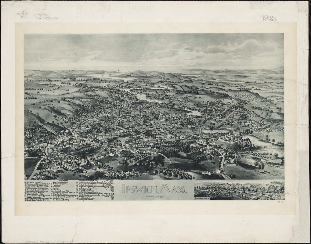
George E. Norris (1855-1926)
Ipswich, Mass.
[Brockton, MA], 1893.
Norman B. Leventhal Map Center at the Boston Public Library.
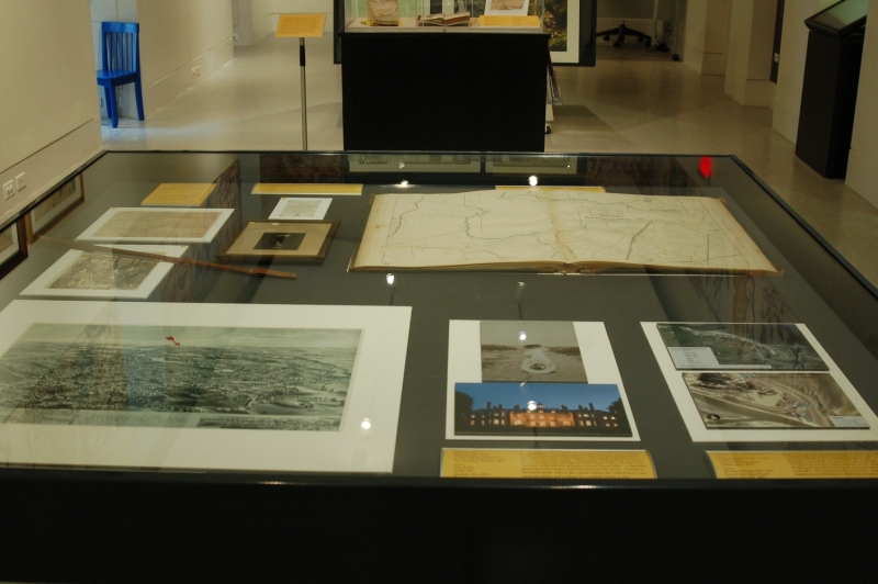
Located on Massachusetts’ northeast coast, Ipswich is home to the Crane Estate. Comprised of three distinct places—Castle Hill (a National Historic Landmark), Crane Beach, and the Crane Wildlife Refuge—the Crane estate once belonged to one of America’s wealthiest families. Castle Hill, illustrated in this 1893 bird’s-eye view, was a farm for centuries before becoming a grand summer estate, complete with stately mansion, European-style outbuildings and gardens. Today tour groups explore the estate, and to the estate’s east, beachgoers enjoy Crane Beach, known for its miles of shoreline and trails. Nearby, in the center of the Essex River Estuary, is the Crane Wildlife Refuge.
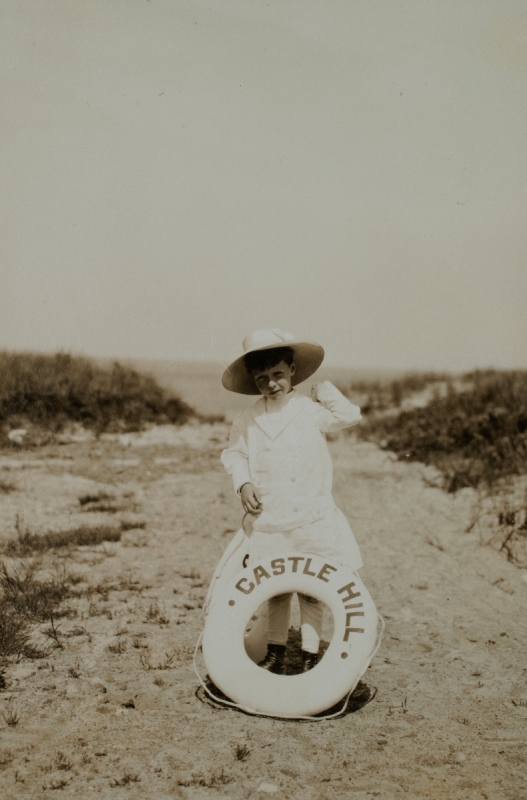
Cornelius Crane
Ipswich, MA, 1910. Digital print, 2016.
Crane Family Collection, Archives & Research Center, The Trustees.
Sharon, Massachusetts.
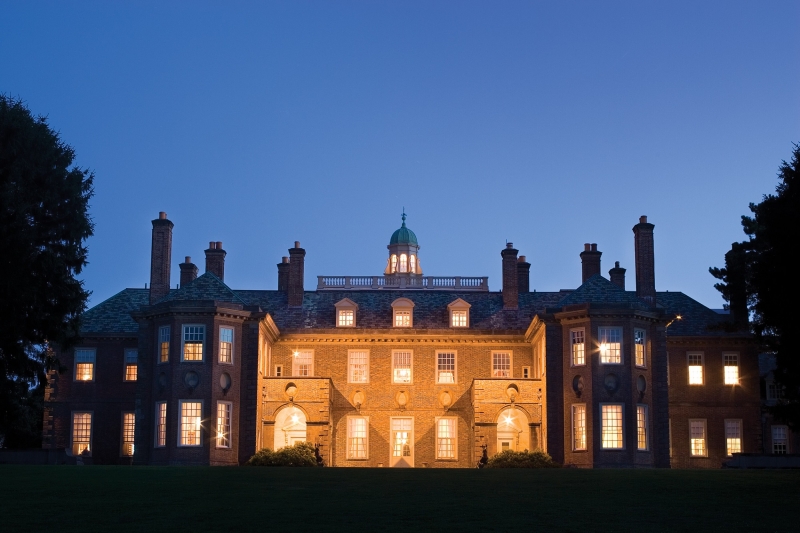
Tom Kates
Castle Hill
Ipswich, MA, 2005. Digital print, 2016.
Courtesy Tom Kates.
It took 18 years (1910-1928) for Mr. and Mrs. Richard T. Crane, Jr. to build their American Country Place summer estate. For its design, they would employ some of America’s premier architects, landscape architects, and sculptors. The top photograph shows their son, Cornelius Crane. The bottom image depicts the Great House, designed by Chicago architect David Adler. The 59-room mansion overlooks the recently restored Grand Allée – a splendid grassy lawn that slopes 2,600 feet down to the ocean. Nestled in the midst of the Allée is the Casino (Italian for “little house”), site of lavish parties and a refuge for a wealthy family at play.
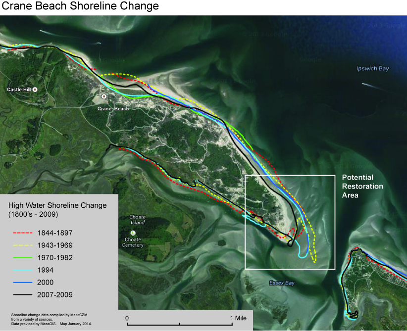
Vincent Antil – GIS Manager, The Trustees
Crane Beach Shoreline Change (1800s-2009)
Leominster, MA, 2014. Digital print, 2016.
The Trustees.
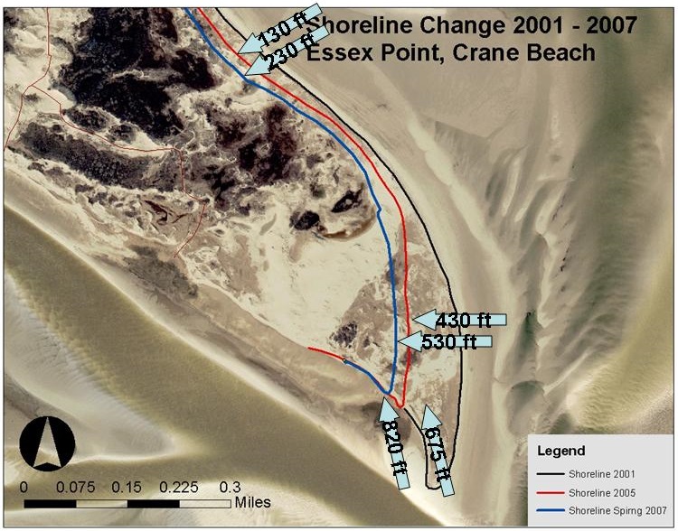
Vincent Antil – GIS Manager, The Trustees
Shoreline Change 2001-2007, Essex Point, Crane Beach
Leominster, MA, 2007. Digital print, 2016.
The Trustees.
These two maps depict Castle Neck in Ipswich, the site of Crane Beach. Using GIS (Geographical Information Systems) and scientific data collected over centuries, these maps show the shoreline change at this dynamic barrier beach. The top map illustrates the change since the mid-19th century, while the detailed view below focuses on variations in the last fifteen years. As sea levels rise and coastal storms occur, coastal erosion and flooding is expected to increase, causing Crane Beach to retreat landward. The fragile beach ecosystem is home to a number of important and threatened plant and animal species.
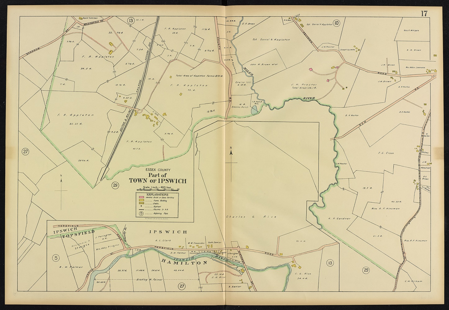
Walker Lithograph & Publishing Co.
“Part of Town of Ipswich, plate 17,” from Atlas of the Towns of Topsfield, Ipswich, Essex, Hamilton and Wenham, Essex County, Massachusetts
Boston, 1910
Norman B. Leventhal Map Center at the Boston Public Library.
Also located in Ipswich is Appleton Farms – America’s oldest continuously operating farm, having been established in 1638. This 1910 map shows the location of the divided properties, which were purchased and consolidated by Francis Randall Appleton, Sr. (1854-1929) in 1904. At this time, the farm included 870 acres of land. In 1912, Francis Sr. conceived of “The Grass Rides,” a series of trails built on the homestead for horseback riding. In 1998 the property was bequeathed to The Trustees by Joan Appleton, wife of the late Francis R. Appleton, Jr., so that the farm and the grasslands would forever be preserved and protected for public use.
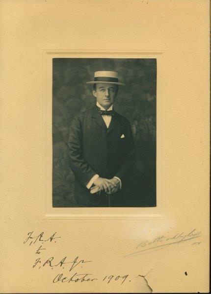
Francis Randall Appleton, Sr.
1909.
Appleton Farms Collection, The Trustees.
Hamilton and Ipswich, MA.
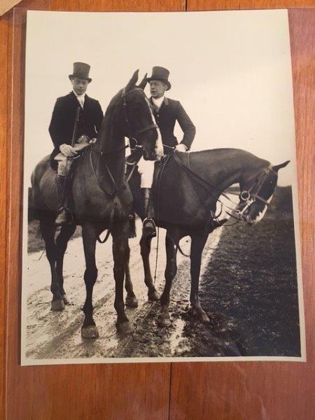
James W. Appleton and HRH Prince Edward at Appleton Farms
Ipswich, MA, 1923.
Appleton Farms Collection, The Trustees.
Hamilton and Ipswich, MA.

Riding Crop
Ca. 1900.
Appleton Farms Collection, The Trustees.
Hamilton and Ipswich, MA.
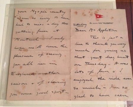
Letter from Prince Edward to James W. Appleton
Written aboard the RMS Olympic, 1923.
Appleton Farms Collection, The Trustees.
Hamilton and Ipswich, MA.
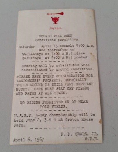
Myopia Hunt Club Fixture Card
South Hamilton, Massachusetts, 1967.
Appleton Farms Collections, The Trustees.
Hamilton and Ipswich, MA.
This portrait shows Francis Randall Appleton, Sr. in 1909, five years after he consolidated the various Appleton properties into one large farm. Francis Sr. inscribed the photo to his 24 year-old son Francis, Jr. Upon retiring a year later, the father happily devoted his time to refurbishing the farm, beautifying the landscape, and increasing the farm’s value. The objects featured here highlight the Appletons’ prominence, their interest in fox hunting, and in their breeding not only horses, but cows, sheep and dogs too. Today, the Myopia Hunt Club still rides through the property and a Jersey herd provides milk and cheese at the farm store.
6. Metrowest & Central
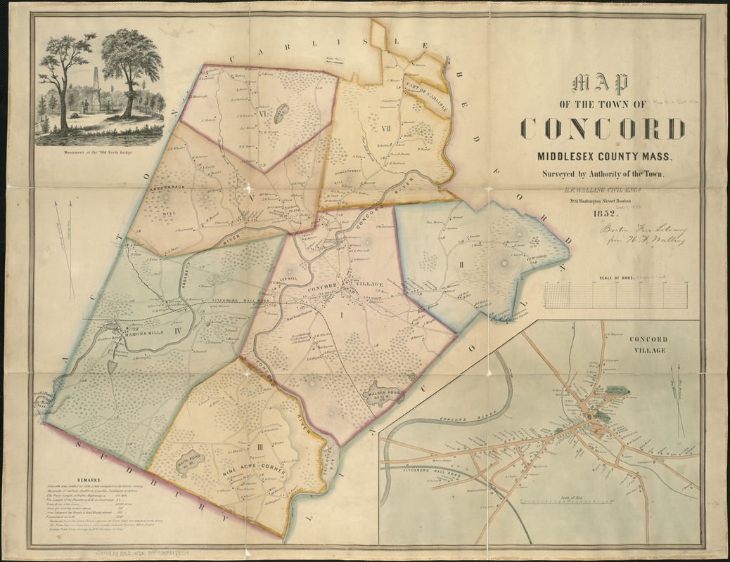
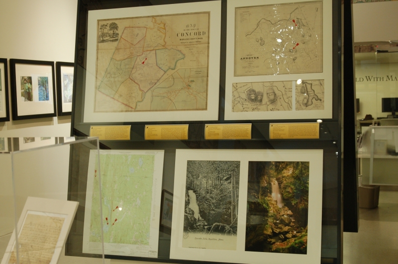
Henry Francis Walling (1825-1888)
Map of the Town of Concord, Middlesex County, Mass.
Boston, 1852.
Norman B. Leventhal Map Center at the Boston Public Library.
Located on the Concord River is The Old Manse. This National Historic Landmark looks over North Bridge, where the first shots of the Revolutionary War were fired on April 19, 1775. Fifty years later, Ralph Waldo Emerson wrote his seminal work Nature here. During his three-year stay, Nathaniel Hawthorne penned Moses from the Manse. This 1852 town map shows the location of The Old Manse and names its owner at the time – Mrs. Sarah Ripley. The house has changed little over the generations. Layers of wallpaper from centuries ago still cling to the plaster walls, and historical ‘graffiti’ is scribbled liberally in closets and etched on windows.
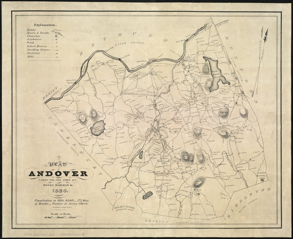
Moses Dorman, Jr. [1803-1877]
A Plan of Andover Taken for the Town
Boston, 1830.
Norman B. Leventhal Map Center at the Boston Public Library.
Ward Reservation in Andover is a place to discover the unique geology of the Merrimack Valley. Comprised of three major hills – Holt, Shrub and Boston – the property contains more than 700 acres for hiking and exploring. Holt Hill – the highest point in Essex County – is a glacial drumlin. At the foot of the hill is a rare quaking bog named Pine Hole Pond. Both of these geological features are illustrated in this 1830 town plan. Nearby Weir Hill, identified here as “Wire Hill,” is a scenic landscape situated on Lake Cochichewick with miles of hiking trails among unique habitat types and rare plant species.
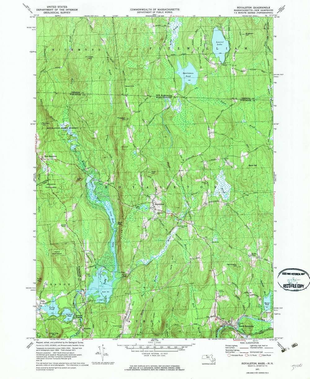
U.S. Geological Survey
Royalston Quadrangle, Massachusetts-New Hampshire, 1971
7.5 Minute Series
Reston, VA, 1971.
Norman B. Leventhal Map Center at the Boston Public Library.
Four Trustees sites located in northern Worcester County near the town of Royalston are shown on this 20th-century topographic map. All sites offer spectacular hikes with gorgeous views. Royalston Falls, a cascade set in a remote site on Falls Brook, dramatically plunges 45 feet into a basin surrounded by an ancient gorge. To the southeast, Jacob’s Hill is a forested landscape with scenic vistas on its two miles of trails including the turbulent Spirit Falls. Nearby is Doane’s Falls, named for a local 19th-century businessman, highlighted by the peaceful Coddings Meadow. The popular Tully Lake Campground lies just to the west.
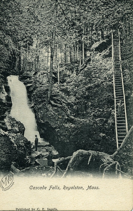
C.E. Ingalls
Cascade Falls, Royalston, MA
[Royalston, MA], 1923. Digital print, 2016.
Archives & Research Center, The Trustees.
Sharon, MA.
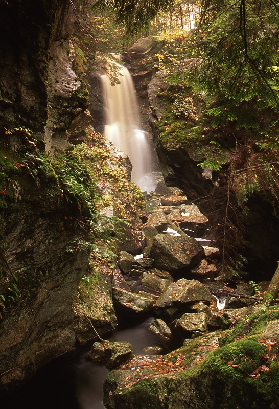
Richard Cheek
“Royalston Falls,” from Land of the Commonwealth
Beverly, MA, 2000. Silver halide print, 2016.
Courtesy Richard Cheek.
In 1841, geology professor Edward Hitchcock wrote, “There are at least three waterfalls connected with deep gorges in Royalston, that are well worth the attention of those who are fond of wild natural scenery.” One of these, formerly known as Forbes Falls, then Cascade Falls – as illustrated on this 1923 postcard – once included amenities such as picnic tables, swings and a ladder for visitors to climb. Today, the forest is slowly erasing the remnants of manmade artifacts from a century ago, and the area is ideal for adventurous hikers. A modern view of the Falls is depicted on the right.
Ralph Waldo Emerson (1803-1882)
May-Day and Other Pieces
Boston, 1867.
Old Manse Collection, The Trustees.
Concord, MA.
Theodore von Rosenthal (fl. 1850-1860)
The German Scholar’s Hand-Book
London, 1858.
Old Manse Collection, The Trustees.
Concord, MA.

Friedrich Schiller (1759-1805)
Das Lied von de Glocke
Lahr, Germany, [ca. 1902]
Old Manse Collection, The Trustees.
Concord, MA.

Sarah Alden Bradford Ripley (1793-1867)
Bignonia (now called Tecoma stans)
Mid-19th Century.
Old Manse Collection, The Trustees.
Concord, MA.
Ralph Waldo Emerson (1803-1882)
Letter to Mary Moody, 1816 February 28
Boston, 1816.
Old Manse Collection, The Trustees.
Concord, MA.
During the 19th century, Concord’s Old Manse became a center of political, literary, and philosophical activity. Here, leading Transcendentalists such as Bronson Alcott, Henry David Thoreau, and Margaret Fuller discussed the issues of the day with the Emerson, Hawthorne and Ripley families. The objects displayed here relate to the occupants’ literary, scientific and religious interests. Ralph Waldo Emerson’s volume of poetry, May-Day and Other Pieces, is inscribed to Sarah Ripley (1793-1867), a self-educated teacher with a passion for botany. Found in the floorboards, a letter penned by the then 12 year-old Emerson reveals his genius at an early age. These German texts demonstrate an interest in a world beyond Concord’s borders.
7. West
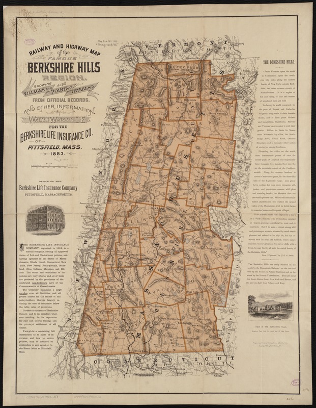
Walter Watson [fl. 1880-1900]
Railway and Highway Map of the Famous Berkshire Hills Region …
New York, 1883.
Norman B. Leventhal Map Center at the Boston Public Library.
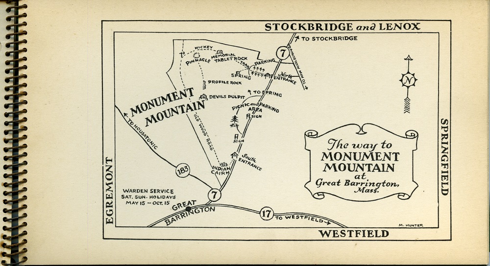
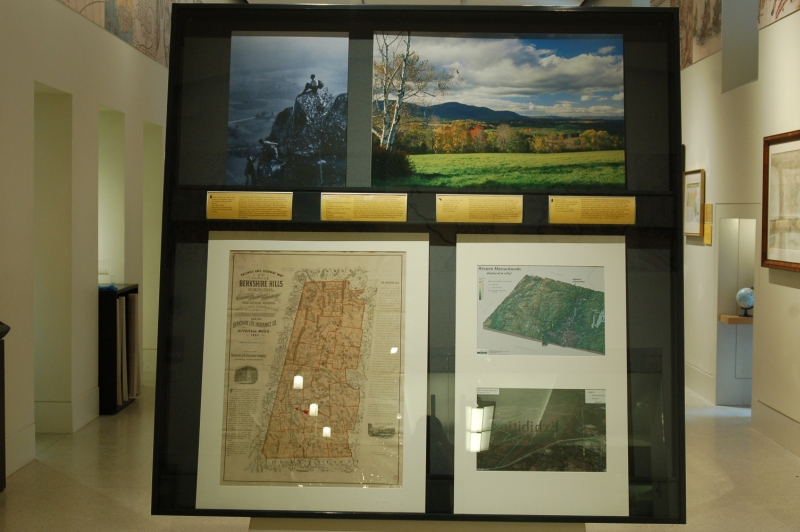
The Berkshire Hills of western Massachusetts are home to a number of Trustees properties. Farms, meadows, ponds, hills, mountains and historic homes make up the fourteen sites in the Berkshires, several of which are depicted on this 1883 map designed to promote tourism in the region. The mountainous topography of the area is highlighted in this map to emphasize the numerous recreational activities available to visitors. Monument Mountain in Great Barrington – one of The Trustees earliest properties – was a popular destination for nature lovers in the 19th century because of its majestic views of the southern Berkshires.
Vincent Antil – GIS Manager, The Trustees
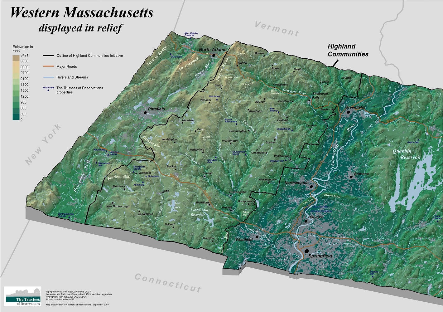
Western Massachusetts Displayed in Relief
Leominster, MA, 2003. Digital print, 2016.
The Trustees.
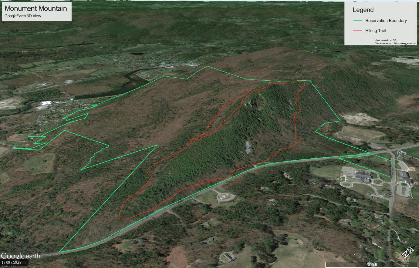
Vincent Antil – GIS Manager, The Trustees
Aerial View of Monument Mountain
Leominster, MA, 2016. Digital print, 2016.
The Trustees.
The relief map of western Massachusetts displayed here echoes the 19th-century map of the Berkshire Hills as it details the numerous mountains and valleys throughout the region. Topography is represented here using shading to differentiate between high and low terrain, and Trustees properties are identified with small triangles. With its 1,642 foot-high peak, Monument Mountain in Great Barrington has long been an attraction for artists, writers, hikers, skiers and nature lovers. The mountain, with the trail to its summit at Squaw Peak is illustrated in the aerial image below. Created using satellites, this view highlights the soaring mountainous peaks as compared to the pastures below.
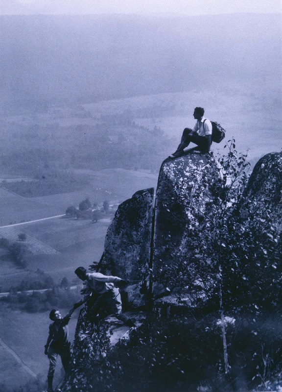
Arthur Palme (1884-1949)
View from Monument Mountain Top
Pittsfield, Massachusetts, 1934. Silver halide print, 2016.
Photo by Palme.
William Cullen Bryant, Nathaniel Hawthorne and Herman Melville all hiked Monument Mountain in the 19th century and were inspired to compose works of poetry and fiction. In this 1934 photograph, a group of hikers trek to the summit of the mountain and take in the spectacular views of the Housatonic River Valley as their literary predecessors once did. The woodlands of Monument Mountain were once clear cut to supply fuel for 19th-century factories in the Valley; however, the mountain is now protected by The Trustees, and will continue to be enjoyed by nature lovers for generations to come.
Richard Cheek
“Bartholomew’s Cobble,” from Land of the Commonwealth
Beverly, MA, 2000. Silver halide print, 2016.
Courtesy Richard Cheek.
Bartholomew’s Cobble in Sheffield is another high point in the Berkshires maintained by The Trustees. Consisting of two rocky knolls, this geologic formation arose when the Taconic and Berkshire Ranges emerged millions of years ago. The rugged landscape supports more than 800 species of plants, from numerous types of ferns to one of the largest Cottonwood trees in the state. Hikers are greeted with scenic views of the Housatonic River Valley when they reach the 1,000-foot high summit of Hurlburt’s Hill. This photograph captures the Cobble’s majestic landscape – as earth meets sky.

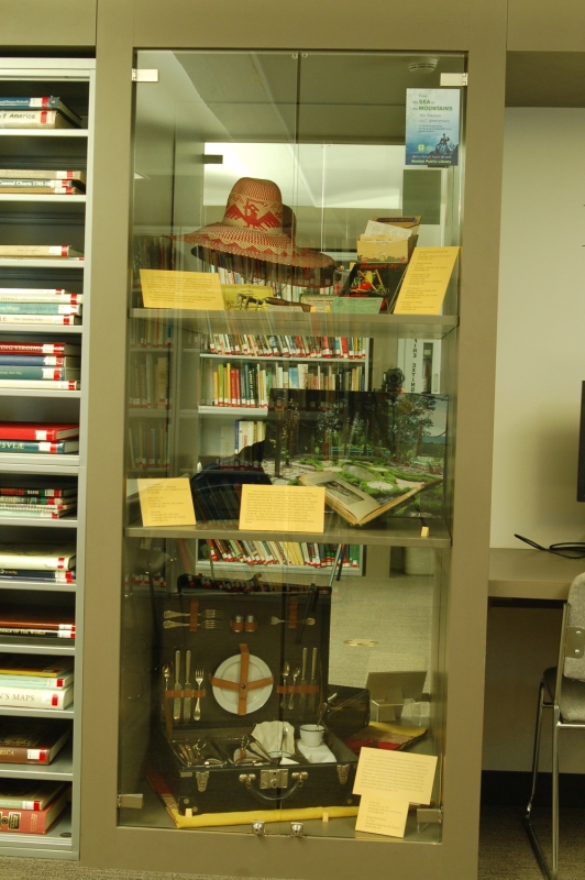
Broad-brimmed Gardening Hat
Ca. 1930.
Naumkeag Collection, The Trustees.
Stockbridge, MA.

Garden Cultivator
Ca. 1935.
Naumkeag Collection, The Trustees.
Stockbridge, MA.
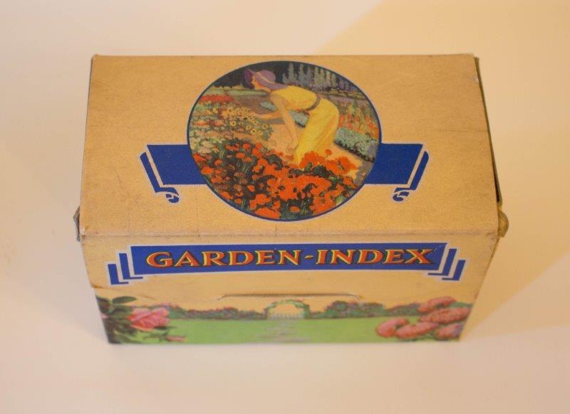
Garden Index Corp
Garden Index Cards
New York, 1938.
Naumkeag Collection, The Trustees.
Stockbridge, MA.

S.L. Allen & Co.
Planet Jr. Farm and Garden Tools
Philadelphia, 1934.
Naumkeag Collection, The Trustees
Stockbridge, MA.
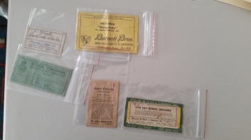
Seed packets (Various)
Ca. 1938.
Naumkeag Collection, The Trustees.
Stockbridge, MA.
A beautiful Gilded Age home with magnificent gardens awaits visitors to Stockbridge, Massachusetts. Naumkeag, the former home of the Choate family, is located on 48 acres of landscaped grounds in the Berkshire Hills. Designed by the architectural firm of McKim, Mead & White – who also designed the Boston Public Library building – the 44-room “cottage” was bequeathed to The Trustees by Miss Mabel Choate in 1958. Displayed here are gardening items used by Mabel Choate while she resided at Naumkeag and worked with renowned landscape architect Fletcher Steele to design the gardens.
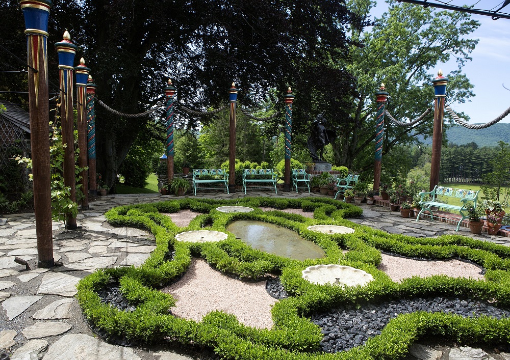
Mark Gardner
Afternoon Garden – Naumkeag
Stockbridge, MA, 2015. Digital reproduction, 2016.
The Trustees.

Blue Cobalt Tile
China, 1948.
Naumkeag Collection, The Trustees
Stockbridge, MA.
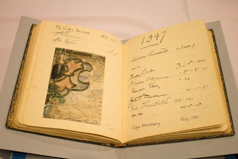
Guestbook
Stockbridge, Massachusetts, 1894-1958.
Naumkeag Collection, The Trustees
Stockbridge, MA.
Known for his vivid use of colors and textures in his design, landscape architect Fletcher Steele helped former estate-owner Mabel Choate update her home’s simple lawn. The newly constructed landscape became the Afternoon Garden, depicted in the photograph here. Moving away from European influenced garden designs, the blue cobalt tile from Naumkeag’s Chinese Temple Garden illustrates Asia’s influence on Steele. The Choate family invited many guests to Naumkeag over the years, and their signatures appear in this guestbook – along with artistic flourishes by some very creative visitors. The objects seen here emphasize the vibrancy of the property, with its use of bright colors, exotic elements and dynamic design.

Picnic Case
Connecticut, ca. 1925.
Naumkeag Collection, The Trustees.
Stockbridge, MA.

Striped Wool Blanket
Ca. 1925.
Naumkeag Collection, The Trustees.
Stockbridge, MA.
This picnic case and blanket from the home’s collection speak to the former residents’ desire to experience the natural landscape of the Berkshires and their love for picnicking. Visitors to Naumkeag today can picnic on the grounds, take in birdwatching or appreciate the extensive garden renovations that have occurred over the last three years — including the meticulous restoration of the Chinese Temple Garden. Perched on the highest point of the property, this garden was the result of a 30-year collaboration between Fletcher Steele and Mable Choate. Its final form was completed only a short time before Ms. Choate’s passing in 1958.
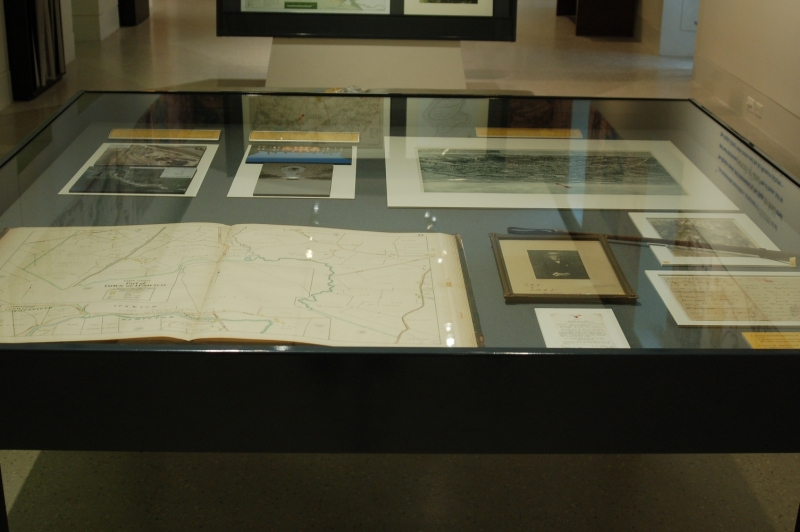
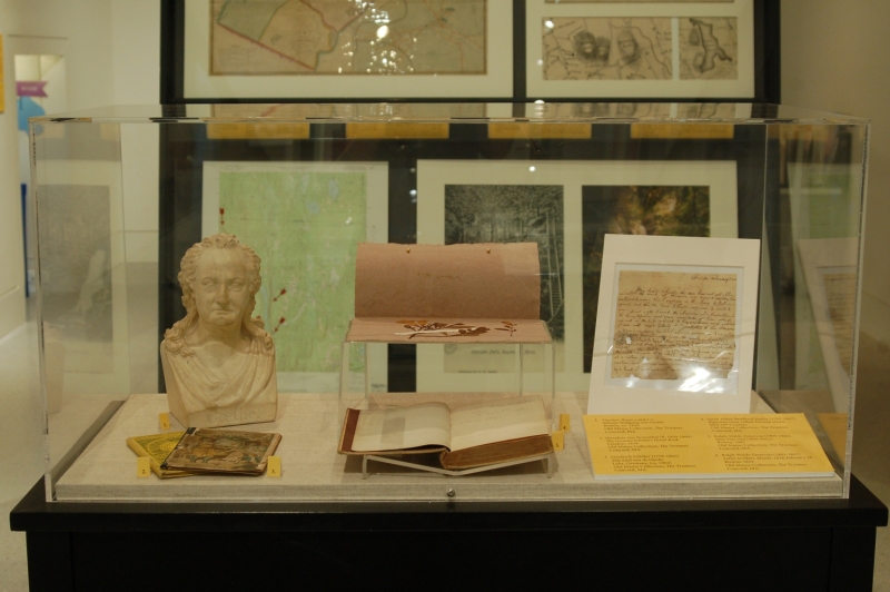
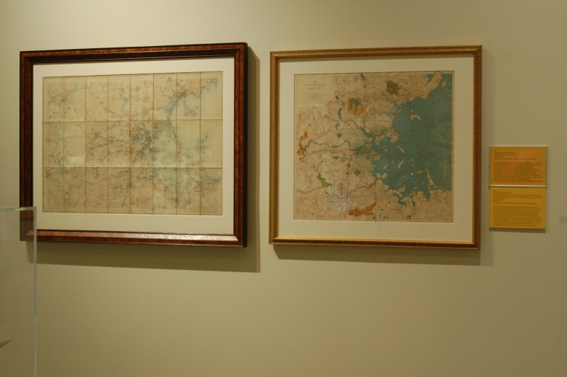
Exhibition Photos
Bibliography
“Reports of the Councillors for the Autumn of 1890: Topography.” Appalachia VI, no. 3 (July 1891): 257-261.
Abbott, Gordon. Saving Special Places: A Centennial History of the Trustees of Reservations, Pioneer of the Land Trust Movement. Ipswich, MA: Ipswich Press, c1993. [HD1695.M3]
Andover Historic Preservation. “89 Prospect Road.” 1 Jan 2015. http://preservation.mhl.org/89-prospect-rd.
Bay Circuit Trail & Greenway. “About the Bay Circuit Trail & Greenway.” 31 Dec 2015. http://www.baycircuit.org/about/.
Caswell, Lilley B. The History of the Town of Royalston Massachusetts. Town of Royalston, 1917. [F74.R92 C3]
Chalofour, Marc. “In Land We Trust.” 10 Feb 2016. http://www.outdoors.org/publications/outdoors/2014/features/in-land-we-trust.cfm.
Cheek, Richard. Land of the Commonwealth: A Portrait of the Conserved Landscapes of Massachusetts. Beverly, MA: Trustees of Reservations; Amherst, MA: University of Massachusetts Press, 2000. [S932.M4 C54 2000x]
Eliot, Charles W. Charles Eliot: Landscape Architect. Originally published: Boston: Houghton Mifflin, 1902. Amherst: University of Massachusetts Press: Library of American Landscape History, 1999. [SB470.E6 E6 1999]
Mann, George C. “Charles Eliot.” Appalachia VIII, no. 3 (July 1897): 244-248.
Massachusetts Geological Survey. Final Report on the Geology of Massachusetts in Four Parts. Amherst, MA: J.S. & C. Adams, 1841.
Palme, Arthur. The Berkshires Through the Camera of Arthur Palme. Pittsfield, MA: Palme-Grove Pub. Co., 1951. [F72.B5 P18]
Presill, Philip, and Nancy Volkman. Landscapes in History: Design and Planning in the Eastern and Western Traditions, 2nd ed. New York: John Wiley and Sons, Inc., 1999. [SB470.5. P74 1999]
Stevenson, Elizabeth. Park Maker: A Life of Frederick Law Olmsted. Originally published: New York: Macmillan, 1977. New Brunswick NJ: Transaction Publishers, 2000. [SB470.O5 S73 2000]
Tilton, Eleanor M., ed. The Letters of Ralph Waldo Emerson: Vol. 7 (1807-1844). New York: Columbia Univ. Press, 1990. [PS1631.A3 1939 v.7]
Trustees of Reservations. First Annual Report of the Trustees of Public Reservations: 1891. Boston, MA: Trustees of Reservations, 1892.
Trustees of Reservations. “Where it All Began.” Special Places (Fall/Winter 2015): 17.
Credits
Curators
Norman B. Leventhal Map Center
Norman B. Leventhal Map Center Staff
Lauren Chen, Cataloger
Connie Chin, President
Alison Cody, Development Manager
Stephanie Cyr, Assistant Curator of Maps
Ronald Grim, Curator of Maps
Michelle LeBlanc, Director of Education
Evan Thornberry, Reference and
Geospatial Librarian
Catherine Wood, Office Manager
Boston Public Library Staff
Communications Dept.
Facilities Dept.
IT Dept.
Graphic Design and Production
Neva Corbo-Hudak Graphic Design
Framing and Matting
Andrew Leonard
Contributors to the Exhibtion
Special Thanks
Elizabeth Holbrook, Museum and Collector Resource
Press
The BPL Celebrates The Trustees of Reservations’ 125th Birthday
The Boston Globe, April 8, 2016
Library Exhibit Celebrates Cultural Heritage
The Huntington News, April 7, 2016
Visualizing Past, Present & Future
Special Places 24, no. 1 (Spring 2016): 24-27