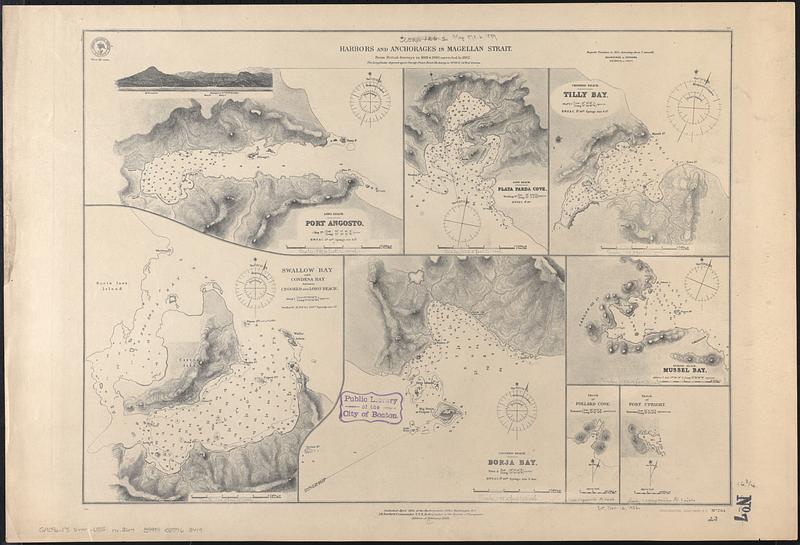
Harbors and anchorages in Magellan Strait : from British surveys in 1868 & 1880, corrected to 1882
Item Information
- Title:
- Harbors and anchorages in Magellan Strait : from British surveys in 1868 & 1880, corrected to 1882
- Issuing body:
- United States. Hydrographic Office
- Date:
-
[1889]
- Format:
-
Maps/Atlases
- Genre:
-
Nautical charts
- Location:
-
Boston Public Library
Norman B. Leventhal Map Center - Collection (local):
-
Norman B. Leventhal Map Center Collection
- Subjects:
-
Magellan, Strait of (Chile and Argentina)--Maps
Angosto Harbor (Chile)--Maps
Playa Parda Cove (Chile)--Maps
Tilly Bay (Chile)--Maps
Swallow Bay (Chile)--Maps
Condesa Bay (Chile)--Maps
Borja Bay (Chile)--Maps
Mussel Bay (Chile)--Maps
Pollard Cove (Chile)--Maps
Upright Harbor (Chile)--Maps
Nautical charts--Chile--Angosto Harbor
Nautical charts--Chile--Playa Parda Cove
Nautical charts--Chile--Tilly Bay
Nautical charts--Chile--Swallow Bay
Nautical charts--Chile--Condesa Bay
Nautical charts--Chile--Borja Bay
Nautical charts--Chile--Mussel Bay
Nautical charts--Chile--Pollard Cove
Nautical charts--Chile--Upright Harbor
- Places:
-
ChileMagallanes y de la Antártica Chilena (region)Angosto, Puerto (harbor)
ChileMagallanes y de la Antártica Chilena (region)Playa Parda, Caleta (cofe)
ChileMagallanes y de la Antártica Chilena (region)Tilly, Bahía (cofe)
ChileMagallanes y de la Antártica Chilena (region)Swallow, Bahía (cofe)
ChileMagallanes y de la Antártica Chilena (region)Condesa, Bahía (cofe)
ChileMagallanes y de la Antártica Chilena (region)Borja, Bahía (cofe)
ChileMagallanes y de la Antártica Chilena (region)Mussel, Bahía (bay)
ChileMagallanes y de la Antártica Chilena (region)Pollard, Caleta (fiord)
ChileMagallanes y de la Antártica Chilena (region)Upright, Bahía (bay)
Magallanes, Estrecho de
- Extent:
- 8 maps on 1 sheet ; 43 x 59 cm
- Terms of Use:
-
No known copyright restrictions.
No known restrictions on use.
- Publisher:
-
Washington, D.C. :
Hydrographic Office
- Edition:
- Edition of February 1889
- Scale:
-
Scales differ
- Language:
-
English
- Table of Contents:
-
Port Angosto
Playa Parda Cove
Tilly Bay
Swallow Bay and Condessa Bay between Crooked and Long Reach
Borja Bay
Mussel Bay
Sketch of Pollard Cove
Sketch of Port Upright
- Notes:
-
Relief shown by hachures and spot heights. Depths shown by soundings and isolines.
Includes view of Passage I.
- Notes (date):
-
This date is inferred.
- Identifier:
-
06_01_017814
- Call #:
-
G9096.P5 svar .U55 no. 264
- Barcode:
-
39999085963419