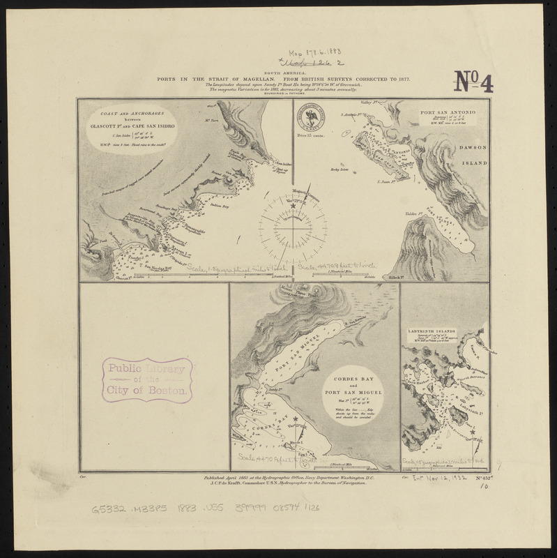
South America, ports in the Strait of Magellan : from British surveys corrected to 1877
Item Information
- Title:
- South America, ports in the Strait of Magellan : from British surveys corrected to 1877
- Title (alt.):
-
Ports in the Strait of Magellan
- Issuing body:
- United States. Hydrographic Office
- Date:
-
1883
- Format:
-
Maps/Atlases
- Location:
-
Boston Public Library
Norman B. Leventhal Map & Education Center - Collection (local):
-
Norman B. Leventhal Map & Education Center Collection
- Subjects:
-
Coasts--Chile--Maps
Nautical charts--Chile--San Antonio Cove
Nautical charts--Chile--San Miguel Cove
Nautical charts--Chile--Cordes Bay
Nautical charts--Chile--Laberinto Island
Nautical charts--Chile--Drew Bay
Magellan, Strait of (Chile and Argentina)--Maps
San Antonio Cove (Chile)--Maps
San Miguel Cove (Chile)--Maps
Cordes Bay (Chile)--Maps
Laberinto Island (Chile)--Maps
Drew Bay (Chile)--Maps
- Places:
-
ChileMagallanes y de la Antártica Chilena (region)San Antonio, Puerto (cove)
ChileMagallanes y de la Antártica Chilena (region)San Miguel, Puerto (cofe)
ChileMagallanes y de la Antártica Chilena (region)Cordes, Bahía (bay)
ChileMagallanes y de la Antártica Chilena (region)Drew, Bahía (bay)
- Extent:
- 4 maps on 1 sheet ; 23 x 26 cm
- Terms of Use:
-
No known copyright restrictions.
No known restrictions on use.
- Publisher:
-
Washington, D.C. :
Hydrographic Office
- Scale:
-
Scale approximtely 1:54,000
Scale approximately 1:54,000
Scale approximately 1:107,000
Scale approximately 1:107,000
- Language:
-
English
- Table of Contents:
-
Coast and anchorages between Glascott Pt. and Cape San Isidro
Port San Antonio
Cordes Bay and Port San Miguel
Labyrinth Islands.
- Identifier:
-
06_01_015889
- Call #:
-
G9096.P5 svar .U55
- Barcode:
-
39999085941126