Toggle navigation
LMEC Home
Exhibitions
Georeferencing
Tools for Teachers
Collections
My Favorites
Sign Up / Log In
Search
Search the map portal
Map Collection
Map Collection
Map Sets
Search
Search
Search for
Search In
All Fields
Creator
Title
Subject
Place
Search All Digital Collections
Advanced Search
4 Results
My Search
Start Over
poland/
Remove constraint poland/
Date
1918
to
1919
Remove constraint Date: <span class='from'>1918</span> to <span class='to'>1919</span>
Filter your Search
Place
Poland
3
Lithuania
1
Russia
1
Topic
Poland--Maps
2
Lithuania--Maps
1
Poland--Boundaries--Maps
1
Poland--History--1918-1945--Maps
1
Russia, Western--Maps
1
Date
1918
to
1919
[remove]
4
Date range begin
–
Date range end
Current results range from
1918
to
1919
1918
to
1918
3
1919
to
1919
1
Creator
American Geographical Society of New York
2
Armbruester, Rudolph A., 1932-
1
C.S. Hammond & Company
1
Fronczak, Francis E.
1
Karasiewicz, Joseph
1
Format
Maps/Atlases
4
Georeferenced
No
4
Collection
Norman B. Leventhal Map Center Collection
4
Available to use
No known restrictions
4
Search Constraints
Search for
portland
or
plans
or
plant
or
plan
or
pond
instead?
Sort by relevance
relevance
title
date (asc)
date (desc)
Number of results to display per page
20 per page
10
per page
20
per page
50
per page
100
per page
View results as:
grid view
map view
Search Results
1.
Poland
2.
Poland & Lithuania
3.
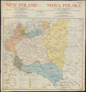
New Poland = Nowa Polska
4.
Large scale map of Russia in Europe