Toggle navigation
LMEC Home
Exhibitions
Georeferencing
Tools for Teachers
Collections
My Favorites
Sign Up / Log In
Search
Search the map portal
Map Collection
Map Collection
Map Sets
Search
Search
Search for
Search In
All Fields
Creator
Title
Subject
Place
Search All Digital Collections
Advanced Search
5 Results
My Search
Start Over
holman
Remove constraint holman
Filter your Search
Place
North and Central America
5
United States
5
Worcester (county)
3
Harvard
2
Massachusetts
2
Bolton
1
Boxboro
1
Middlesex (county)
1
more
Place
»
Topic
Aeronautical charts--Minnesota
1
Airports--Minnesota--Maps
1
Runways (Aeronautics)--Minnesota
1
Date
Date range begin
–
Date range end
Current results range from
1794
to
1990
View distribution
Creator
Holman, Silas, 1760-1846
3
Holman, Silas
1
United States. National Ocean Service
1
Format
Maps/Atlases
5
Georeferenced
No
5
Collection
Town plans, 1794
2
Town plans, 1830
2
U.S. Government Documents Maps Collection
1
Available to use
No known restrictions
5
Search Constraints
Search for
human
instead?
Sort by relevance
relevance
title
date (asc)
date (desc)
Number of results to display per page
20 per page
10
per page
20
per page
50
per page
100
per page
View results as:
grid view
map view
Search Results
1.
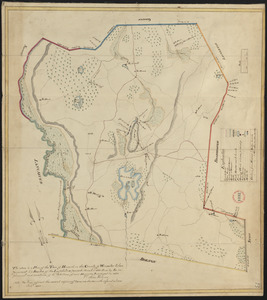
Plan of Harvard made by Silas Holman, dated 1830
2.
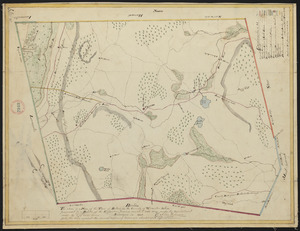
Plan of Bolton made by Silas Holman, dated 1830
3.
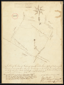
Plan of Boxborough made by Silas Holman, dated November, 1794.
4.
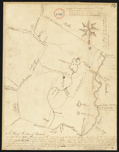
Plan of Harvard surveyed by Silas Holman, dated October 1794.
5.
Airport obstruction chart : OC 263, St. Paul Downtown Holman Field, St. Paul, Minnesota