Toggle navigation
LMEC Home
Exhibitions
Georeferencing
Tools for Teachers
Collections
My Favorites
Sign Up / Log In
Search
Search the map portal
Map Collection
Map Collection
Map Sets
Search
Search
Search for
Search In
All Fields
Creator
Title
Subject
Place
Search All Digital Collections
Advanced Search
6 Results
My Search
Start Over
g3464
Remove constraint g3464
Filter your Search
Place
Canada
6
North and Central America
6
Toronto
3
Collingwood
1
Ottawa
1
Saint Thomas
1
Topic
Toronto (Ont.)--Maps
3
Carleton (Ont.)--Maps
1
Collingwood (Ont.)--Aerial views
1
Landowners--Ontario--Carleton--Maps
1
Landowners--Ontario--Ottawa--Maps
1
Ottawa (Ont.)--Maps
1
Real property--Ontario--Carleton--Maps
1
Real property--Ontario--Ottawa--Maps
1
more
Topic
»
Date
Date range begin
–
Date range end
Current results range from
1863
to
1924
View distribution
Creator
Brosius, H.
2
Copp Clark Company
1
Gray, Ormando Willis.
1
Rand McNally and Company
1
Thulstrup, B. T.
1
Format
Maps/Atlases
6
Georeferenced
Yes
1
No
5
Collection
Norman B. Leventhal Map Center Collection
6
Urban Maps
4
Available to use
No known restrictions
6
Search Constraints
Sort by relevance
relevance
title
date (asc)
date (desc)
Number of results to display per page
100 per page
10
per page
20
per page
50
per page
100
per page
View results as:
grid view
map view
Search Results
1.
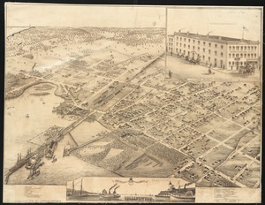
Bird's eye view of Collingwood, Ontario, Canada
2.
City of Toronto : compiled from surveys made to the present date
3.
City of Toronto, reduced by permission from Wadsworth & Unwin's large map
4.
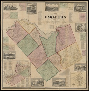
Map of the county of Carleton, Canada West : from surveys under the direction of H.F. Walling
5.
Rand McNally standard map of Toronto and environs
6.
St. Thomas, Province, Ontario Canada, 1875