Toggle navigation
LMEC Home
Exhibitions
Georeferencing
Tools for Teachers
Collections
My Favorites
Sign Up / Log In
Search
Search the map portal
Map Collection
Map Collection
Map Sets
Search
Search
Search for
Search In
All Fields
Creator
Title
Subject
Place
Search All Digital Collections
Advanced Search
1176 Results
My Search
Start Over
Date
1900
to
1920
Remove constraint Date: <span class='from'>1900</span> to <span class='to'>1920</span>
Filter your Search
Place
North and Central America
846
United States
723
Massachusetts
269
Europe
152
Suffolk (county)
143
Boston
140
Canada
82
Asia
68
more
Place
»
Topic
Boston (Mass.)--Maps
81
Landowners--Massachusetts--Boston--Maps
55
United States--Maps
36
Real property--Massachusetts--Boston--Maps
35
Massachusetts--Maps
29
Fire risk assessment
26
Insurance surveys
26
Europe--Maps
24
more
Topic
»
Date
1900
to
1920
[remove]
1,176
Date range begin
–
Date range end
Current results range from
1770
to
1999
1900
to
1901
174
1902
to
1903
196
1904
to
1905
137
1906
to
1907
123
1908
to
1909
106
1910
to
1911
117
1912
to
1913
113
1914
to
1915
151
1916
to
1917
136
1918
to
1919
177
1920
to
1920
74
Creator
Bromley, George Washington
49
Bromley, Walter Scott
49
American Geographical Society of New York
39
Geological Survey (U.S.)
34
United States. Post Office Dept
34
G.W. Bromley & Co.
33
Geological Survey of Canada
30
Gross, Alexander, 1879-1958
28
more
Creator
»
Format
Maps/Atlases
1,166
Books
11
Manuscripts
7
Photographs
6
Prints
4
Documents
1
Objects/Artifacts
1
Posters
1
Georeferenced
Yes
157
No
1,019
Collection
Norman B. Leventhal Map & Education Center Collection
1,077
Boston and New England Maps
106
Urban Maps
94
Massachusetts Real Estate Atlases
53
American Textile History Museum Image Collection
26
Robert E. Diefenbach Map Collection at Phillips Academy
13
Maritime Charts and Atlases
9
Mapping Boston Collection
5
more
Collection
»
Available to use
No known restrictions
1,087
Creative Commons license
7
Search Constraints
Sort by relevance
relevance
title
date (asc)
date (desc)
Number of results to display per page
10 per page
10
per page
20
per page
50
per page
100
per page
View results as:
grid view
map view
Search Results
1.
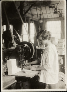
15-year old girl punching cards. Boston Index Card Co., 113 Purchase Street.
2.
1903 Map of Salem and surrounding places
3.
The A.A.A. key road map of continental Europe
4.
Acushnet Mill Corp. (Cotton Mill), New Bedford, Mass. [insurance map]
5.
Adriatic
6.
Aero view of Canton, Mass. 1918
7.
Aero view of Lynn, Mass, 1916 : looking north
8.
Aeronautical view of the Panama Canal
9.
Africa
10.
Africa
‹ Prev
Next ›
1
2
3
4
5
…
117
118


![Acushnet Mill Corp. (Cotton Mill), New Bedford, Mass. [insurance map]](https://bpldcassets.blob.core.windows.net/derivatives/images/commonwealth:ww72bz30x/image_thumbnail_300.jpg)


