Toggle navigation
LMEC Home
Exhibitions
Georeferencing
Tools for Teachers
Collections
My Favorites
Sign Up / Log In
Search
Search the map portal
Map Collection
Map Collection
Map Sets
Search
Search
Search for
Search In
All Fields
Creator
Title
Subject
Place
Search All Digital Collections
Advanced Search
286 Results
My Search
Start Over
1880
Remove constraint 1880
Filter your Search
Place
North and Central America
252
United States
241
Massachusetts
97
Wisconsin
46
Suffolk (county)
41
Boston
39
Europe
14
Worcester (county)
14
more
Place
»
Topic
Manuscript maps
47
Boston (Mass.)--Maps
16
United States--Maps
8
City planning--Massachusetts--Boston--Maps
6
New England--Maps
5
Real property--Massachusetts--Boston--Maps
5
Dorchester (Boston, Mass.)--Maps
4
East Boston (Boston, Mass.)--Maps
4
more
Topic
»
Date
Date range begin
–
Date range end
Current results range from
1756
to
2008
View distribution
Creator
United States. Hydrographic Office
19
Campbell-Copeland, T. (Thomas)
7
Dougal, William H., 1822-1895
7
Harper & Brothers
7
U.S. Lake Survey
7
O.H. Bailey & Co
6
Bigelow, E. H.
5
United States. Topographical Bureau
5
more
Creator
»
Format
Maps/Atlases
284
Manuscripts
92
Books
4
Prints
1
Georeferenced
Yes
20
No
266
Collection
Norman B. Leventhal Map & Education Center Collection
267
Boston and New England Maps
100
Urban Maps
71
Maritime Charts and Atlases
27
Massachusetts Real Estate Atlases
8
American Revolutionary War-Era Maps
5
Robert E. Diefenbach Map Collection at Phillips Academy
5
Campus Maps from Phillips Academy Archives and Special Collections
2
more
Collection
»
Available to use
No known restrictions
271
Creative Commons license
3
Search Constraints
Sort by relevance
relevance
title
date (asc)
date (desc)
Number of results to display per page
20 per page
10
per page
20
per page
50
per page
100
per page
View results as:
grid view
map view
Search Results
161.
Richmond
162.
Russell
163.
Sea of Japan, Oki Island, Saigo Harbor : from a Japanese government survey in 1879
164.
Shaker Village
165.
South America, west coast, Chile, Coronel, Lota & Colcura anchorages in Arauco Bay : from a Chilean government survey in 1878
166.
South Pacific, Fiji or Viti Group, Ngau Island and Mumbolithe Reef
167.
Spencer
168.
Springfield
169.
Views of Lot's Wife, taken from Meares' Voyage and from the sketch-book of the U.S. Ship Vincennes, November 1854 ; Borodino...
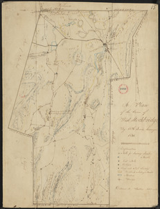
170.
Warren
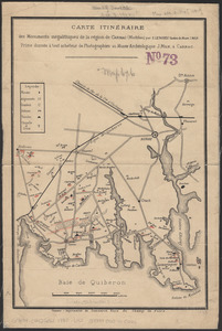
171.
Washington
172.
West Brookfield
173.
Westfield
174.
Wilbraham
175.
Worcester station
176.
Plan of West Stockbridge made by B. H. Lewis, dated 1831
177.
ABC pathfinder railway guide map : eastern division
178.
Carte itinéraire des monuments mégalithiques de la région de Carnac (Morbihan)
179.
City of Toronto, reduced by permission from Wadsworth & Unwin's large map
180.
Clemens' map of Pennsylvania
‹ Prev
Next ›
1
2
…
5
6
7
8
9
10
11
12
13
14
15