Toggle navigation
LMEC Home
Exhibitions
Georeferencing
Tools for Teachers
Collections
My Favorites
Sign Up / Log In
Search
Search the map portal
Map Collection
Map Collection
Map Sets
Search
Search
Search for
Search In
All Fields
Creator
Title
Subject
Place
Search All Digital Collections
Advanced Search
297 Results
My Search
Start Over
1780
Remove constraint 1780
Filter your Search
Place
North and Central America
251
United States
171
Canada
40
New York
32
Charleston (county)
31
Charleston
27
South Carolina
22
New Jersey
17
more
Place
»
Topic
United States--History--Revolution, 1775-1783--Maps
54
Manuscript maps--Early works to 1800
22
Charleston (S.C.)--Maps
11
Charleston (S.C.)--Siege, 1780--Maps
9
Fortification--Newfoundland and Labrador--St. John's--Maps, Manuscript--Early works to 1800
9
Harbors--Newfoundland and Labrador--St. John's--Maps, Manuscript--Early works to 1800
9
Military art and science--Newfoundland and Labrador--St. John's--Maps, Manuscript--Early works to 1800
9
St. John's (N.L.)--Maps, Manuscript--Early works to 1800
9
more
Topic
»
Date
Date range begin
–
Date range end
Current results range from
1711
to
1909
View distribution
Creator
Skinner, Monier
28
Skinner, William, 1700-1780
28
Des Barres, Joseph F. W. (Joseph Frederick Wallet), 1722-1824
25
Faden, William, 1749-1836
16
André, John, 1751-1780
11
Bonne, Rigobert, 1727-1794
8
Carver, Jonathan, 1710-1780
6
Ferguson, Patrick, 1744-1780
6
more
Creator
»
Format
Maps/Atlases
291
Manuscripts
71
Prints
5
Drawings/Illustrations
1
Georeferenced
Yes
7
No
290
Collection
American Revolutionary War-Era Maps
266
Norman B. Leventhal Map Center Collection
66
William L. Clements Library Collection
65
Library of Congress Collection
63
British Library Collection
33
Maritime Charts and Atlases
27
Richard H. Brown Revolutionary War Map Collection at Mount Vernon
26
Boston and New England Maps
13
more
Collection
»
Available to use
Creative Commons license
142
No known restrictions
66
Search Constraints
Sort by date (desc)
relevance
title
date (asc)
date (desc)
Number of results to display per page
20 per page
10
per page
20
per page
50
per page
100
per page
View results as:
grid view
map view
Search Results
121.
A new and correct map of North America : in which the places of the principal engagements during the present war are accurately...
122.
A new and correct map of North America : in which the places of the principal engagements during the present war are accurately...
123.
A New map of the province of Maryland in North America
124.
Nieuwe en zeer accuraate generaale caart van de twee rievieren Berbice en Canje met alle desselfs plantagien en gronden op...
125.
North America
126.
The north point of Grandmanan Island in the bay Fundy bearing e.n.e distant two leagues ; A view of Campo Bello at the entrance...
127.
The north point of Grandmanan Island in the bay Fundy bearing e.n.e distant two leagues ; A view of Campo Bello at the entrance...
128.
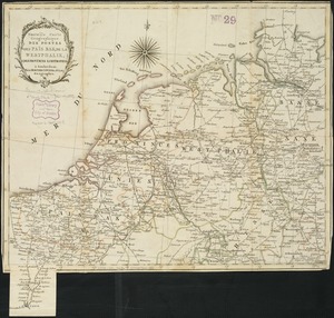
Nouvelle carte geographique des postes des Païs Bas, de la Westphalie, & des provinces limitrophes
129.
Operations in America : No. 2
130.
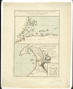
The operations of His Majesty's squadron in the Bay of Honduras, under the command of the Hon. John Luttrell from the 15th of...
131.
[Panoramic view of Newport, Rhode Island and the harbor showing the position of the French fleet and troop encampments]
132.
Part of modern Brunswick County
133.
Part of modern Brunswick County
134.
Part of modern Charleston County
135.
Part of the modern counties of Currituck, Camden, and Pasquotank, North Carolina
136.
Part of the modern counties of Hudson and Bergen, New Jersey
137.
Partie occidentale du Canada, : contenant les cinq Grands Lacs, avec les pays circonvoisins
138.
Partie occidentale du Canada contenant les cinqs grands lac [sic], avec les pays criconvoisins [sic]
139.
[Plan de Gibraltar]
140.
Plan de la baie de Narraganset dans la Nouvelle Angleterre : avec toutes les îles qu'elle renferme parmi lesquelles se...
‹ Prev
Next ›
1
2
3
4
5
6
7
8
9
10
11
…
14
15


![[Panoramic view of Newport, Rhode Island and the harbor showing the position of the French fleet and troop encampments]](https://bpldcassets.blob.core.windows.net/derivatives/images/commonwealth:dz010v493/image_thumbnail_300.jpg)

![Partie occidentale du Canada contenant les cinqs grands lac [sic], avec les pays criconvoisins [sic]](https://bpldcassets.blob.core.windows.net/derivatives/metadata/commonwealth-oai:tx31vg299/image_thumbnail_300.jpg)
![[Plan de Gibraltar]](https://bpldcassets.blob.core.windows.net/derivatives/images/commonwealth:z603vt83t/image_thumbnail_300.jpg)