Toggle navigation
LMEC Home
Exhibitions
Georeferencing
Tools for Teachers
Collections
My Favorites
Sign Up / Log In
Search
Search the map portal
Map Collection
Map Collection
Map Sets
Search
Search
Search for
Search In
All Fields
Creator
Title
Subject
Place
Search All Digital Collections
Advanced Search
83 Results
My Search
Start Over
1866
Remove constraint 1866
Filter your Search
Place
North and Central America
65
United States
51
Boston
21
Suffolk (county)
21
Europe
8
Boston Harbor
4
Central Europe
3
Massachusetts
3
more
Place
»
Topic
Boston (Mass.)--Maps
15
Real property--Massachusetts--Boston--Maps
5
Boston (Mass.)--Aerial views
3
Boston Harbor (Mass.)--Maps
3
Europe, Central--Maps
3
Harbors--Massachusetts--Boston--Maps
3
New England--Maps
3
Railroads--New England--Maps
3
more
Topic
»
Date
Date range begin
–
Date range end
Current results range from
1826
to
1898
View distribution
Creator
Hotchkiss, Jedediah, 1828-1899
4
United States Coast Survey
4
United States. Hydrographic Office
4
U.S. Lake Survey
3
Bache, A. D. (Alexander Dallas), 1806-1867
2
Boston (Mass.). Engineering Dept
2
Hayward, James, 1786-1866
2
Johnson, A. J. (Alvin Jewett), 1827-1884
2
more
Creator
»
Format
Maps/Atlases
81
Manuscripts
3
Prints
2
Georeferenced
Yes
10
No
73
Collection
Norman B. Leventhal Map Center Collection
79
Boston and New England Maps
35
Urban Maps
24
Maritime Charts and Atlases
10
Mapping Boston Collection
3
Ralph Finos Map Collection at Phillips Academy
2
Robert E. Diefenbach Map Collection at Phillips Academy
1
Town plans, 1830
1
Available to use
No known restrictions
80
Creative Commons license
3
Search Constraints
Sort by relevance
relevance
title
date (asc)
date (desc)
Number of results to display per page
20 per page
10
per page
20
per page
50
per page
100
per page
View results as:
grid view
map view
Search Results
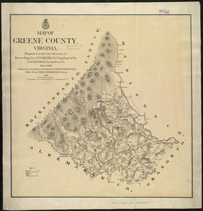
81.
Map of Greene County, Virginia
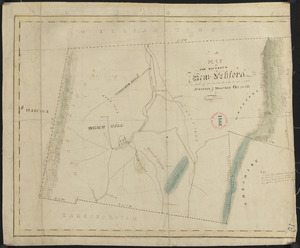
82.
Plan of New Ashford made by Phinehas Harmon, dated October 1830
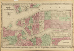
83.
Johnson's map of New York and the adjacent cities
‹ Prev
Next ›
1
2
3
4
5