Toggle navigation
LMEC Home
Exhibitions
Georeferencing
Tools for Teachers
Collections
My Favorites
Sign Up / Log In
Search
Search the map portal
Map Collection
Map Collection
Map Sets
Search
Search
Search for
Search In
All Fields
Creator
Title
Subject
Place
Search All Digital Collections
Advanced Search
14164 Results
Filter your Search
Place
North and Central America
10,811
United States
8,818
Massachusetts
2,820
Suffolk (county)
1,688
Boston
1,644
Europe
1,428
Canada
1,010
New York
683
more
Place
»
Topic
Boston (Mass.)--Maps
753
City planning--Massachusetts--Boston--Maps
419
United States--History--Revolution, 1775-1783--Maps
331
United States--Maps
331
Real property--Massachusetts--Boston--Maps
254
Urban renewal--Massachusetts--Boston--Maps
254
North America--Maps--Early works to 1800
241
Massachusetts--Maps
236
more
Topic
»
Date
Date range begin
–
Date range end
Current results range from
1482
to
2023
View distribution
Creator
United States. Hydrographic Office
597
Boston Redevelopment Authority
404
Des Barres, Joseph F. W. (Joseph Frederick Wallet), 1722-1824
247
Jefferys, Thomas, -1771
172
United States. National Ocean Service
170
Royal United Services Institute for Defence and Security Studies
160
George, III, King of Great Britain, 1738-1820
152
George, IV, King of Great Britain, 1762-1830
151
more
Creator
»
Format
Maps/Atlases
13,978
Manuscripts
985
Prints
102
Books
53
Drawings/Illustrations
44
Photographs
15
Objects/Artifacts
13
Documents
7
more
Format
»
Georeferenced
Yes
979
No
13,185
Collection
Norman B. Leventhal Map & Education Center Collection
9,162
American Revolutionary War-Era Maps
3,629
Boston and New England Maps
2,936
Urban Maps
2,511
Maritime Charts and Atlases
1,169
William L. Clements Library Collection
910
Library of Congress Collection
618
Boston Redevelopment Authority Collection
475
more
Collection
»
Available to use
No known restrictions
10,408
Creative Commons license
1,678
Search Constraints
Sort by relevance
relevance
title
date (asc)
date (desc)
Number of results to display per page
20 per page
10
per page
20
per page
50
per page
100
per page
View results as:
grid view
map view
Search Results
9621.
Plan of Hebron, surveyor's name not given, dated December 1794.
9622.
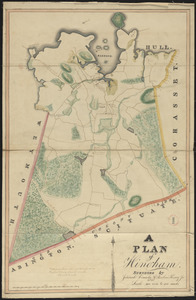
Plan of Hingham made by Jedediah Lincoln and Reuben Hersey, Jr., dated 1830
9623.
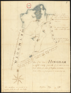
Plan of Hingham, surveyor's name not given, dated May, 1795.
9624.
Plan of Hinsdale, surveyor's name not given, dated 1830
9625.
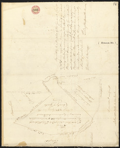
Plan of Hiram, Me., including Wadsworth's Grant, Phillips' Claim and Cutler's Grant, surveyor's name not given, dated November...
9626.
Plan of Holden made by Charles Chaffin, dated October 20, 1831
9627.
Plan of Holden, made by Jonathan Peirce, dated May 20, 1795.
9628.
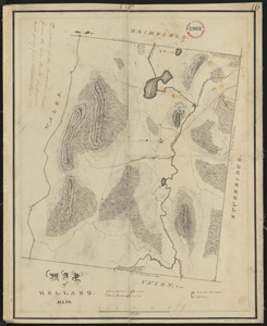
Plan of Holland made by Emerson Johnson, dated 1831
9629.
Plan of Holland, surveyor's name not given, dated February 17, 1795
9630.
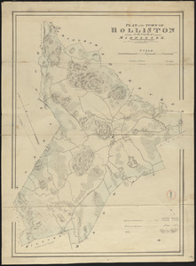
Plan of Holliston made by John G. Hales, dated 1831
9631.
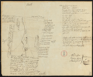
Plan of Holliston surveyed by Samuel Bullard, dated 1794.
9632.
Plan of Hoosac Tunnel Dock and Elevator Company's docks and land in Charlestown, Mass.
9633.
Plan of Hopkinton, made by Matthew Metcalf, dated 1794.
9634.
Plan of Hopkinton made by Matthew Metcalf, dated 1831
9635.
Plan of house lots & other lands offered for sale by the Boston Water Power Company
9636.
Plan of house lots at Newton Corner near the residence of Dr. Hitchcock, lately belonging to W.S. Tuckerman
9637.
Plan of house lots at Oak Sq. Brighton : belonging to Oak Sq. Land Trust
9638.
[Plan of house lots for sale on Savin Hill Avenue, Dorchester, Mass.]
9639.
Plan of house lots in Boston belonging to Otis H. Weed
9640.
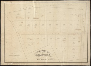
Plan of house lots in Braintree : to be sold at public auction on Saturday May 25th 1850 at 3 o'clock p.m. on the premises
‹ Prev
Next ›
1
2
…
478
479
480
481
482
483
484
485
486
…
708
709


![[Plan of house lots for sale on Savin Hill Avenue, Dorchester, Mass.]](https://bpldcassets.blob.core.windows.net/derivatives/images/commonwealth:9s161f68b/image_thumbnail_300.jpg)