Toggle navigation
LMEC Home
Exhibitions
Georeferencing
Tools for Teachers
Collections
My Favorites
Sign Up / Log In
Search
Search the map portal
Map Collection
Map Collection
Map Sets
Search
Search
Search for
Search In
All Fields
Creator
Title
Subject
Place
Search All Digital Collections
Advanced Search
13385 Results
Filter your Search
Place
North and Central America
10,111
United States
8,249
Massachusetts
2,691
Suffolk (county)
1,664
Boston
1,621
Europe
1,386
Canada
949
New York
640
more
Place
»
Topic
Boston (Mass.)--Maps
741
City planning--Massachusetts--Boston--Maps
418
United States--History--Revolution, 1775-1783--Maps
329
United States--Maps
315
Urban renewal--Massachusetts--Boston--Maps
254
Real property--Massachusetts--Boston--Maps
252
Massachusetts--Maps
219
Insurance surveys
197
more
Topic
»
Date
Date range begin
–
Date range end
Current results range from
1482
to
2023
View distribution
Creator
United States. Hydrographic Office
595
Boston Redevelopment Authority
403
Des Barres, Joseph F. W. (Joseph Frederick Wallet), 1722-1824
247
Royal United Services Institute for Defence and Security Studies
160
Jefferys, Thomas, -1771
154
George, III, King of Great Britain, 1738-1820
152
George, IV, King of Great Britain, 1762-1830
151
O.H. Bailey & Co
148
more
Creator
»
Format
Maps/Atlases
13,205
Manuscripts
985
Prints
102
Books
49
Drawings/Illustrations
44
Photographs
15
Objects/Artifacts
13
Documents
7
more
Format
»
Georeferenced
Yes
979
No
12,406
Collection
Norman B. Leventhal Map & Education Center Collection
8,891
American Revolutionary War-Era Maps
3,305
Boston and New England Maps
2,804
Urban Maps
2,397
Maritime Charts and Atlases
1,150
William L. Clements Library Collection
910
Library of Congress Collection
618
Boston Redevelopment Authority Collection
475
more
Collection
»
Available to use
No known restrictions
9,952
Creative Commons license
1,677
Search Constraints
Sort by relevance
relevance
title
date (asc)
date (desc)
Number of results to display per page
20 per page
10
per page
20
per page
50
per page
100
per page
View results as:
grid view
map view
Search Results
8741.
Plan of corner of Centry & Beacon St's -- 1741
8742.
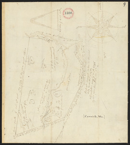
Plan of Cornish, made by John Wingate, dated May 1, 1795.
8743.
Plan of cottage lots on Littlejohn's Island, Casco Bay, about 7 1/2 miles northeast of Portland
8744.
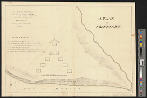
A plan of Croft-town : an encampment intended by Major McKenzie for the troops at Mobile during the unhealthy season
8745.
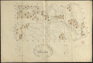
Plan of Cummington, made by Adam Packard, dated May 15, 1795.
8746.
Plan of Cummington, surveyor's name not given, dated June 1831
8747.
Plan of Cushing surveyed by James Malcolm, dated April 16, 1795.
8748.
Plan of Cutler's Grant (Porter) made by Nathaniel Merrill, dated 1794-1795.
8749.
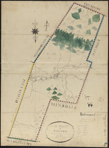
Plan of Dalton made by M. H. Eames, dated October 27, 1831
8750.
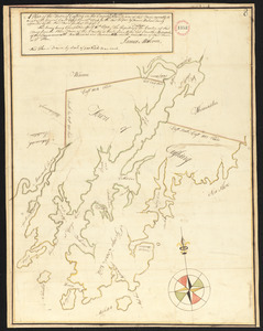
Plan of Dalton, surveyor's name not given, dated 1794-5.
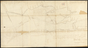
8751.
Plan of Damons land
8752.
Plan of Dana made by Ephraim Whipple, dated May 18, 1831
8753.
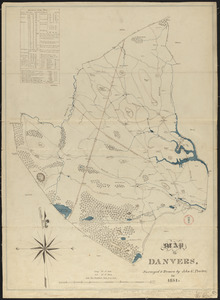
Plan of Danvers made by John W. Proctor, dated 1831
8754.
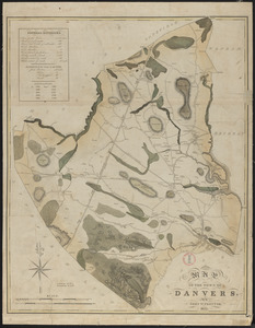
Plan of Danvers made by John W. Proctor, dated 1832
8755.
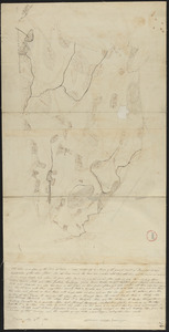
Plan of Danvers surveyed by Gideon Foster, dated May, 1795.
8756.
Plan of Dartmouth made by Henry H. Crapo, dated June, 1831
8757.
Plan of Dartmouth, made by Zedock Maxfeld, dated May, 1795.
8758.
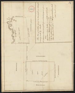
Plan of Dean Danl Greens farm in Reading
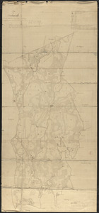
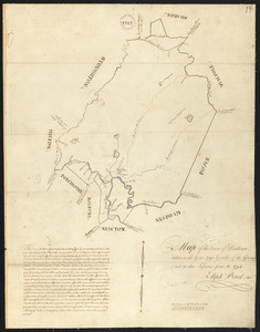
8759.
Plan of Dedham, made by Elijah Pond, dated 1795.
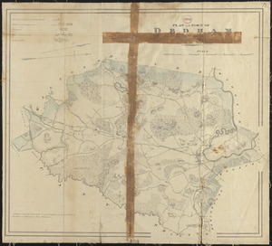
8760.
Plan of Dedham made by John G. Hales, dated 1831
‹ Prev
Next ›
1
2
…
434
435
436
437
438
439
440
441
442
…
669
670