Toggle navigation
LMEC Home
Exhibitions
Georeferencing
Tools for Teachers
Collections
My Favorites
Sign Up / Log In
Search
Search the map portal
Map Collection
Map Collection
Map Sets
Search
Search
Search for
Search In
All Fields
Creator
Title
Subject
Place
Search All Digital Collections
Advanced Search
105 Results
My Search
Start Over
Date
1919
Remove constraint Date: <span class='single'>1919</span>
Filter your Search
Place
North and Central America
71
United States
66
Europe
25
New England
15
Massachusetts
13
Czechoslovakia
8
New York
8
Austria
6
more
Place
»
Topic
New England--Maps--Early works to 1800--Facsimiles
12
Czechoslovakia--Maps
8
Czechoslovakia--Population--Maps
8
Industries--Czechoslovakia--Maps
8
Austria--Maps
6
Hungary--Maps
4
World maps
4
Ethnology--Europe--Maps
3
more
Topic
»
Date
1919
[remove]
105
Date range begin
–
Date range end
Current results range from
1770
to
1999
1919
to
1919
105
Creator
Smith, John, 1580-1631
9
Czechoslovakia. Service cartographique de l'armée
8
Geological Survey (U.S.)
7
Lesher, C. E. (Carl Eugene), 1885-
7
American Geographical Society of New York
4
Bromley, George Washington
3
Bromley, Walter Scott
3
Illinois State Geological Survey
3
more
Creator
»
Format
Maps/Atlases
104
Books
1
Photographs
1
Georeferenced
Yes
12
No
93
Collection
Norman B. Leventhal Map & Education Center Collection
100
Urban Maps
6
Boston and New England Maps
4
Massachusetts Real Estate Atlases
3
American Revolutionary War-Era Maps
1
Robert E. Diefenbach Map Collection at Phillips Academy
1
Sidney R. Knafel Map Collection at Phillips Academy
1
Available to use
No known restrictions
100
Creative Commons license
1
Search Constraints
Sort by relevance
relevance
title
date (asc)
date (desc)
Number of results to display per page
20 per page
10
per page
20
per page
50
per page
100
per page
View results as:
grid view
map view
Search Results
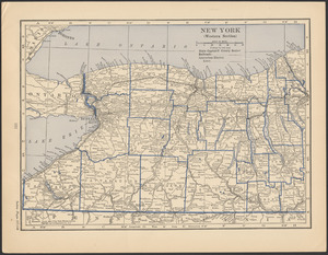
61.
New York (western section)
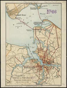
62.
Norfolk & Portsmouth Traction Company's lines are shown in red
63.
Northern Alberta : map showing disposition of lands
64.
Official map of American and Canadian airways and aerial mail routes
65.
The official map of the world : showing the four quarters of the globe on the quarter-spherical or orange peel projection
66.
Part of New York City
67.
Plan and section, Salmon River gold district, Halifax Co., N.S
68.
Plan of corner of Centry & Beacon St's -- 1741
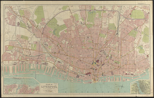
69.
Plan of Liverpool
70.
Plan of the burnt district : showing proposed improvements in streets. Nov. 12th 1872
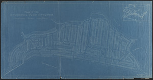
71.
Plan of the Kenberma Park Estates : Nantasket Beach, Hull, Mass.
72.
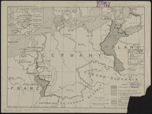
Post-World War I Germany
73.
Progress of construction, government railroad, Alaska
74.
The races of Europe
75.
Railroad distance map of the United States, Mexico & Canada
76.
The Rand McNally new commercial atlas map of North Carolina
77.
Romania
78.
A small map of the sea coast of New England together with the outlines of several of the provinces lying thereon, 1738
79.
The south part of New-England, as it is planted this yeare, 1635
80.
State of Illinois
‹ Prev
Next ›
1
2
3
4
5
6