Toggle navigation
LMEC Home
Exhibitions
Georeferencing
Tools for Teachers
Collections
My Favorites
Sign Up / Log In
Search
Search the map portal
Map Collection
Map Collection
Map Sets
Search
Search
Search for
Search In
All Fields
Creator
Title
Subject
Place
Search All Digital Collections
Advanced Search
58 Results
My Search
Start Over
Date
1745
Remove constraint Date: <span class='single'>1745</span>
Filter your Search
Place
North and Central America
42
Canada
25
Louisbourg
17
United States
9
North America
7
Africa
5
Nova Scotia
5
America
4
more
Place
»
Topic
Louisbourg (N.S.)--Maps, Manuscript--Early works to 1800
13
Louisbourg (N.S.)--History--Siege, 1745--Maps, Manuscript--Early works to 1800
12
Military maps--Early works to 1800
7
United States--History--King George’s War, 1744-1748--Maps, Manuscript--Early works to 1800
6
Austrian Succession, War of, 1740-1748--Maps, Manuscript--Early works to 1800
5
Military art and science--Nova Scotia--Louisbourg--Maps, Manuscript--Early works to 1800
5
Fortification--Nova Scotia--Louisbourg--Maps, Manuscript--Early works to 1800
4
Louisbourg (N.S.)--Maps
3
more
Topic
»
Date
1745
[remove]
58
Date range begin
–
Date range end
Current results range from
1699
to
1800
1745
to
1745
58
Creator
Bastide, John Henry, approximately 1700-1770
13
George, III, King of Great Britain, 1738-1820
11
George, IV, King of Great Britain, 1762-1830
11
Durell, Philip, -1766
8
Royal United Services Institute for Defence and Security Studies
8
Amherst, Jeffery Amherst, Baron, 1717-1797
7
Skinner, Monier
4
Skinner, William, 1700-1780
4
more
Creator
»
Format
Maps/Atlases
58
Manuscripts
15
Georeferenced
Yes
1
No
57
Collection
American Revolutionary War-Era Maps
39
British Library Collection
23
Norman B. Leventhal Map & Education Center Collection
19
William L. Clements Library Collection
10
MacLean Collection Map Library
2
Library of Congress Collection
1
Newberry Library Collection
1
Ralph Finos Map Collection at Phillips Academy
1
more
Collection
»
Available to use
Creative Commons license
25
No known restrictions
20
Search Constraints
Sort by relevance
relevance
title
date (asc)
date (desc)
Number of results to display per page
20 per page
10
per page
20
per page
50
per page
100
per page
View results as:
grid view
map view
Search Results
41.
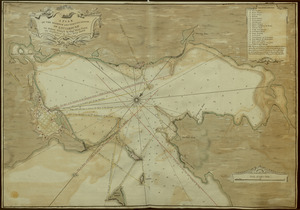
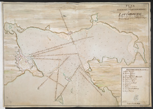
A PLAN OF THE HARBOUR AND FORTIFICATIONS OF LOUISBOURG
42.
A PLAN OF THE HARBOUR AND FORTIFICATIONS OF LOUISBOURG
43.
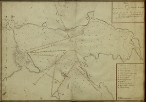
Plan of the HARBOUR and FORTIFICATIONS OF LOUISBOURG
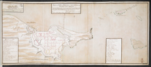
44.
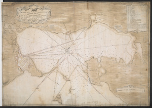
A PLAN OF THE HARBOUR AND FORTIFICATIONS OF LOUISBOURG : The Harbour Survey'd by Cap.t Phi; Durrell The Fortifications by Cap.t...
45.
PLAN of the HARBOUR and FORTIFICATIONS of LOUISBOURG : The Harbour Survey'd by Capt Phill Durell the Town & Fortifications by...
46.
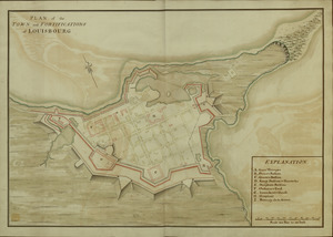
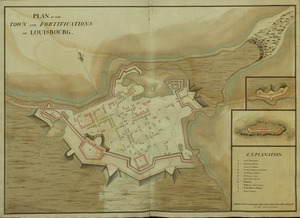
PLAN of the TOWN and FORTIFICATIONS of LOUISBOURG
47.
PLAN of the TOWN and FORTIFICATIONS of LOUISBOURG
48.
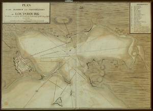
PLAN of the TOWN and FORTRESS of LOUISBOURG on the ISLAND CAPE BRETON : Surrender'd ye 16th June 1745 after a Seige of 12 days...
49.
Les principales forteresses, ports &c. de l'Amérique septentrionale
50.
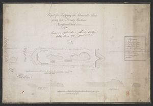
Project for Fortifying the Admiralls Point going into Trinity Harbour Newfoundland Octob.r 1745
51.
River valley with several foothills and swamp
52.
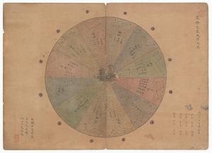
Shinsen zouho Kyo oezu
53.
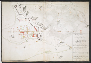
Superficial Sketch of an advantagious Fortification for LOUISBOURG
54.
Totius Americae descriptio nova
55.
A tract of land granted to George Murray and Jacobas Bruyn lying & being in the county of Ulster on the west side of the Wall...
56.
Triangles on Mercator projection between St. Augustine and Cape Breton and St. Augustine and Cape Ortegal
57.
Virginia Marylandia et Carolina in America septentrionali Brittannorum industria excultæ
58.
Xingye dingxiang fang yangzhitu
‹ Prev
Next ›
1
2
3