Toggle navigation
LMEC Home
Exhibitions
Georeferencing
Tools for Teachers
Collections
My Favorites
Sign Up / Log In
Search
Search the map portal
Map Collection
Map Collection
Map Sets
Search
Search
Search for
Search In
All Fields
Creator
Title
Subject
Place
Search All Digital Collections
Advanced Search
34 Results
My Search
Start Over
Date
1943
Remove constraint Date: <span class='single'>1943</span>
Filter your Search
Place
North and Central America
19
United States
18
Massachusetts
8
Boston
6
Suffolk (county)
6
Asia
5
New England
5
World
4
more
Place
»
Topic
World War, 1939-1945--Maps
4
World maps
4
Aeronautics
3
Boston (Mass.)--Maps
3
New England--Maps--Early works to 1800--Facsimiles
3
Aerial views
2
Airways--Maps
2
Military maps
2
more
Topic
»
Date
1943
[remove]
34
Date range begin
–
Date range end
Current results range from
1770
to
1999
1943
to
1943
34
Creator
Chase, Ernest Dudley, 1878-1966
2
U.S. Coast and Geodetic Survey
2
United States. Army Air Forces
2
United States. Army Air Forces. Publications Division
2
United States. Bureau of Naval Personnel. Educational Services Section
2
United States. Office of Strategic Services. Geography Division
2
United States. Office of Strategic Services. Research and Analysis Branch
2
Aluminum Company of America
1
more
Creator
»
Format
Maps/Atlases
33
Photographs
1
Georeferenced
Yes
1
No
33
Collection
Norman B. Leventhal Map & Education Center Collection
29
Boston and New England Maps
4
Ralph Finos Map Collection at Phillips Academy
3
Urban Maps
2
American Revolutionary War-Era Maps
1
American Textile History Museum Image Collection
1
Sidney R. Knafel Map Collection at Phillips Academy
1
Available to use
No known restrictions
30
Creative Commons license
1
Search Constraints
Sort by relevance
relevance
title
date (asc)
date (desc)
Number of results to display per page
20 per page
10
per page
20
per page
50
per page
100
per page
View results as:
grid view
map view
Search Results
21.
A pictorial map of loveland
22.
Plan of corner of Centry & Beacon St's -- 1741
23.
Plan of the burnt district : showing proposed improvements in streets. Nov. 12th 1872
24.
Railroads of Lithuania, 1939
25.
Los recursos de los Estados Unidos
26.
Roads and communications of Sinkiang
27.
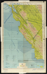
San Francisco (RS-1) sectional aeronautical chart
28.
A small map of the sea coast of New England together with the outlines of several of the provinces lying thereon, 1738
29.
The south part of New-England, as it is planted this yeare, 1635
30.
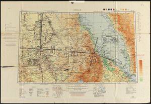
Sudan
31.
To his excellency William Shirley Esqr., Captain General and Commander in Chief, in and over his Majesty's province of the...
32.
Town of Brookline Mass. Assessors' plans 1943
33.
The town of Winchester, Massachusetts
34.
White Mountain National Forest : New Hampshire-Maine
‹ Prev
Next ›
1
2