Toggle navigation
LMEC Home
Exhibitions
Georeferencing
Tools for Teachers
Collections
My Favorites
Sign Up / Log In
Search
Search the map portal
Map Collection
Map Collection
Map Sets
Search
Search
Search for
Search In
All Fields
Creator
Title
Subject
Place
Search All Digital Collections
Advanced Search
154 Results
My Search
Start Over
Date
1903
Remove constraint Date: <span class='single'>1903</span>
Filter your Search
Place
North and Central America
133
United States
114
Massachusetts
45
Boston
32
Suffolk (county)
32
Canada
11
Oklahoma
10
New York
7
more
Place
»
Topic
Boston (Mass.)--Maps
23
Landowners--Massachusetts--Boston--Maps
20
Indian reservations--Oklahoma--Maps
9
Indian Territory--Maps
7
Oklahoma--Maps
7
Boston (Mass.)--History--Colonial period, ca. 1600-1775--Maps
5
Homeowners--Massachusetts--Boston--Maps
5
Cambridge (Mass.)--Maps
3
more
Topic
»
Date
1903
[remove]
154
Date range begin
–
Date range end
Current results range from
1770
to
1999
1903
to
1903
154
Creator
United States. Post Office Dept
34
Lamb, George
16
United States. Commission to the Five Civilized Tribes
8
Julius Bien & Co.
6
Scarborough Company
5
United States. Post Office Department
5
Lamb, George.
4
Canada. Department of the Interior
3
more
Creator
»
Format
Maps/Atlases
152
Books
1
Photographs
1
Prints
1
Georeferenced
Yes
24
No
130
Collection
Norman B. Leventhal Map & Education Center Collection
146
Boston and New England Maps
23
Urban Maps
21
Massachusetts Real Estate Atlases
3
Robert E. Diefenbach Map Collection at Phillips Academy
3
Maritime Charts and Atlases
2
American Revolutionary War-Era Maps
1
Lucius Beebe Memorial Library Historic Maps
1
more
Collection
»
Available to use
No known restrictions
150
Search Constraints
Sort by relevance
relevance
title
date (asc)
date (desc)
Number of results to display per page
20 per page
10
per page
20
per page
50
per page
100
per page
View results as:
grid view
map view
Search Results
21.
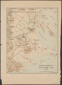
District annexed to New York City in 1895
22.
A draught of St. John's harbour : with the soundings
23.
Elihu Geer's sons' new map of Hartford from the latest surveys
24.
Family of Mrs. Donovan, Roxbury
25.
Gesandtschaftsviertel in Peking
26.
Gloucester, Essex County, Massachusetts : Oct. 1903
27.
Guide map of Boston
28.
Highway map of Plymouth County, Massachusetts : prepared for the Plymouth County atlas
29.
Indian Territory : progress of sub-division survey, June 30, 1902
30.
Indian Territory
31.
Indian Territory showing railroad systems - June 30, 1902
32.
Indian Territory showing townsites approved to June 30-1902
33.
Ireland
34.
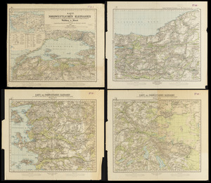
Karte des nordwestlichen Kleinasien : nach eigenen aufnahmen und unveröffentlichtem material auf Heinrich Kiepert's grundlage
35.
Lake Winnipesaukee, New Hampshire
36.
Maine Central Railroad : through the White Mountains
37.
Map of British Columbia and part of western Canada, showing the lines and lands of the Canadian Pacific Railway
38.
Map of Cambridge in the vicinity of Harvard College 1903-4
39.
Map of Cape Nome and adjacent mining dists
40.
Map of Choctaw Nation, Indian Territory
‹ Prev
Next ›
1
2
3
4
5
6
7
8