Toggle navigation
LMEC Home
Exhibitions
Georeferencing
Tools for Teachers
Collections
My Favorites
Sign Up / Log In
Search
Search the map portal
Map Collection
Map Collection
Map Sets
Search
Search
Search for
Search In
All Fields
Creator
Title
Subject
Place
Search All Digital Collections
Advanced Search
31 Results
My Search
Start Over
Date
1706
Remove constraint Date: <span class='single'>1706</span>
Filter your Search
Place
North and Central America
13
Europe
9
United States
9
France
5
New York
4
North America
3
Spain
3
World
3
more
Place
»
Topic
Africa, West--Maps--Early works to 1800
2
America--Maps--Early works to 1800
2
Azores--Maps--Early works to 1800
2
Canary Islands--Maps--Early works to 1800
2
Cape Verde--Maps--Early works to 1800
2
North America--Maps--Early works to 1800
2
Virginia--Maps--Early works to 1800
2
Western Hemisphere--Maps--Early works to 1800
2
more
Topic
»
Date
1706
[remove]
31
Date range begin
–
Date range end
Current results range from
1668
to
1800
1706
to
1706
31
Creator
Jaillot, Alexis Hubert, 1632?-1712
3
Burghers, M.
2
Chatelain, Henri Abraham.
2
Nolin, Jean Baptiste, 1686-1762
2
Aa, Pieter van der, 1659-1733
1
Cordier, Louis, -1711
1
George, III, King of Great Britain, 1738-1820
1
George, IV, King of Great Britain, 1762-1830
1
more
Creator
»
Format
Maps/Atlases
30
Manuscripts
3
Drawings/Illustrations
1
Georeferenced
No
31
Collection
Norman B. Leventhal Map & Education Center Collection
21
American Revolutionary War-Era Maps
9
William L. Clements Library Collection
7
Maritime Charts and Atlases
3
Boston and New England Maps
1
British Library Collection
1
Library of Congress Collection
1
MacLean Collection Map Library
1
Available to use
No known restrictions
21
Creative Commons license
2
Search Constraints
Sort by relevance
relevance
title
date (asc)
date (desc)
Number of results to display per page
20 per page
10
per page
20
per page
50
per page
100
per page
View results as:
grid view
map view
Search Results
21.
Part of modern Orange County
22.
Part of New England
23.
Paskaart van de cust van Portugal, Barbaria en Genehoa : beginnende van d'Barlenges tot aan C. Verde met al zyn Diepte en...
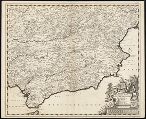
24.
Regnorum Castellae novae, Andalusiae, Granadae, Valentiae, et Murciae, in episcopatus etc. divisorum
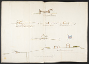
25.
The Respective Profiles belonging to the great Iconografical Draughts of Castle Island in the Bay of Boston
26.
River valley with several foothills and swamp
27.
Shinsen zouho Kyo oezu
28.
A tract of land granted to George Murray and Jacobas Bruyn lying & being in the county of Ulster on the west side of the Wall...
29.
Triangles on Mercator projection between St. Augustine and Cape Breton and St. Augustine and Cape Ortegal
30.
Virginia, Maryland, Pennsilvania, east & west New Jarsey
31.
Virginia Marylandia et Carolina in America septentrionali Brittannorum industria excultæ
‹ Prev
Next ›
1
2