Toggle navigation
LMEC Home
Exhibitions
Georeferencing
Tools for Teachers
Collections
My Favorites
Sign Up / Log In
Search
Search the map portal
Map Collection
Map Collection
Map Sets
Search
Search
Search for
Search In
All Fields
Creator
Title
Subject
Place
Search All Digital Collections
Advanced Search
21 Results
My Search
Start Over
1957
Remove constraint 1957
Filter your Search
Place
North and Central America
19
United States
18
Massachusetts
11
Boston
8
Suffolk (county)
8
Franklin (county)
2
Rowe
2
Andover
1
more
Place
»
Topic
Boston (Mass.)--Maps
3
Islands of the Pacific--Maps
2
Massachusetts--Maps
2
Pacific Area--Maps
2
Parks--Massachusetts--Boston--Maps
2
United States--Maps
2
Art--Islands of the Pacific--Maps
1
Art--Pacific Area--Maps
1
more
Topic
»
Date
Date range begin
–
Date range end
Current results range from
1830
to
1989
View distribution
Creator
Shurcliff, Arthur A. (Arthur Asahel), 1870-1957
8
Boston (Mass.). Department of Parks
4
Covarrubias, Miguel, 1904-1957
2
Farnsworth, E. P.
2
Harris, Cynthia, 1957-
2
Massachusetts Coastal Zone Management Office
2
Massachusetts. Metropolitan Improvements Commission
2
Pacific House (Monterey, Calif.)
2
more
Creator
»
Format
Maps/Atlases
21
Georeferenced
Yes
1
No
20
Collection
Norman B. Leventhal Map & Education Center Collection
16
Boston and New England Maps
9
Urban Maps
5
Boston Redevelopment Authority Collection
2
Mapping Boston Collection
2
Town plans, 1830
2
American Textile History Museum Image Collection
1
Applied Geographics, Inc. Records
1
more
Collection
»
Available to use
No known restrictions
17
Creative Commons license
2
Search Constraints
Sort by relevance
relevance
title
date (asc)
date (desc)
Number of results to display per page
20 per page
10
per page
20
per page
50
per page
100
per page
View results as:
grid view
map view
Search Results
21.
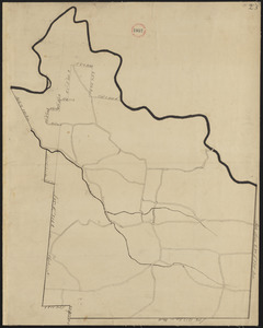
Plan of Rowe made by E. P. Farnsworth, dated June 1830
‹ Prev
Next ›
1
2